
Sucre facts for kids
Quick facts for kids
Sucre
Sukri, Chuquisaca, Charcas
|
|||
|---|---|---|---|
|
Panoramic view
Gran Mariscal Sucre Theater
Church of San Francisco
Gran Mariscal Sucre Theater, Church of San Francisco, Panoramic view of historic Sucre
|
|||
|
|||
| Nickname(s):
La Ciudad de los cuatro Nombres
(The City of the four names)
|
|||
| Motto(s):
Aqui nació la Libertad
(Freedom was born here)
|
|||

Sucre
Location in Bolivia

Sucre
Location in South America
|
|||
| Country | Bolivia | ||
| Department | Chuquisaca Department | ||
| Province | Oropeza Province | ||
| Founded | 1538
|
||
| Founded by | Pedro Anzures as "La Plata" in 1538 | ||
| Government | |||
| • Type | C.S. Municipal Autonomous Government | ||
| Area | |||
| • Capital city | 1,768 km2 (683 sq mi) | ||
| Elevation | 2,790 m (9,150 ft) | ||
| Population
(2021)
|
|||
| • Capital city | 360,544 | ||
| • Density | 203.93/km2 (528.17/sq mi) | ||
| • Metro | 390,000 | ||
| Demonym(s) | Capitalino (a) Sucrense |
||
| Time zone | UTC−04:00 (Bolivia Time) | ||
| • Summer (DST) | (Not Observed) | ||
| Area code | (+591) 4 | ||
| Climate | Cwb | ||
| UNESCO World Heritage Site | |||
| Official name | Historic City of Sucre | ||
| Criteria | Cultural: iv | ||
| Inscription | 1991 (15th Session) | ||

.jpg)


Sucre is the official capital city of Bolivia. It is also the main city of the Chuquisaca Department. Sucre is the sixth largest city in Bolivia by population.
The city is located in the south-central part of the country. It sits high up, at about 2,790 meters (9,153 feet) above sea level. This high altitude gives Sucre a special climate. It has cool temperatures all year round, like a mountain climate.
Over many years, Sucre has had different names. These include La Plata, Charcas, and Chuquisaca. Today, many people in the region are from the Quechua group. There are also some Aymara communities.
Sucre is very important for Bolivia. It is a big center for education and government. The country's highest court, the Bolivian Supreme Court, is located here. Sucre is known for its pleasant weather and low crime. This makes it a popular place for both locals and visitors.
The city has one of the best-preserved old city centers from the time of Spanish rule. It looks a lot like other historic cities such as Cuzco and Quito. Because of its beautiful old buildings and long history, Sucre is a UNESCO World Heritage Site. This means it's a special place recognized by the United Nations for its importance to the world.
Contents
History of Sucre
Before the Spanish arrived, Sucre was an Inca town called Chuquisaca. This name is still used for the city sometimes today. The name Chuquisaca might come from Quechua words meaning 'precious metal' or 'a pile of silver'.
Chuquisaca was the capital of a region called Charca. This area was taken over by Topa Inka Yupanqui. He made the Quechua language common there. The people of Charca were known as strong warriors. Many of them became soldiers for the Inca ruler Wayna Qhapaq.
In 1525, a European explorer named Aleixo Garcia might have been the first to reach Charcas. Later, in 1538, Francisco Pizarro sent his brothers to claim the region for Spain. They learned about the rich silver and gold mines in the area.
Founding the City
The Spanish officially founded Sucre on November 30, 1538. They named it Ciudad de la Plata de la Nueva Toledo. This means "City of Silver of New Toledo." Pedro Anzures, a Spanish leader, founded the city.
In 1559, the Spanish King Philip II created the Audiencia de Charcas in La Plata. This was a powerful court that governed a huge area. It included parts of what are now Paraguay, Peru, Chile, Argentina, and Bolivia.
Over the years, important religious and educational places were built. The Recoleta Monastery was founded in 1601. An archbishopric (a church district led by an archbishop) was set up in 1609. In 1624, the St Francis Xavier University of Chuquisaca was founded. This is one of the oldest universities in the Americas.

During the time of Spanish rule, Sucre was a very Spanish city. Its narrow streets and beautiful buildings show the style from southern Spain. Many buildings are grand houses, convents, and churches. Sucre is still the main center for the Roman Catholic Church in Bolivia.
For a long time, Spanish royalty and rich families liked Sucre's mild climate. They were often involved in the silver trade from Potosí, a nearby mining city.
Road to Independence
On May 25, 1809, the movement for Bolivia's independence began in Sucre. The bell of the Basilica of Saint Francisco rang so hard it broke! This bell is still in the Basilica today and is a very important piece of history for the city.
Until the 1800s, La Plata was the main center for law, religion, and culture in the region. In July 1826, it was named the temporary capital of the newly independent country, which later became Bolivia. On July 12, 1839, President José Miguel de Velasco officially made the city the capital of Bolivia. He also renamed it Sucre to honor the independence hero Antonio José de Sucre.
Later, the silver industry in Potosí declined. Because of this, the main government offices of Bolivia moved from Sucre to La Paz in 1898. Many people believe that the fight for independence in Latin America against Spain started in Sucre. Bolivia was one of the last Spanish territories in South America to become independent, in 1825. In 1991, Sucre was named a UNESCO World Heritage Site.
Geography and City Layout
.jpg)
Sucre is divided into eight areas called districts. The first five districts are in the city itself. Districts 6, 7, and 8 are rural areas with many small communities outside the city. Each district has a Sub-Mayor who helps manage it.
The city is served by Alcantari Airport. This airport is about 30 kilometers (18.6 miles) south of Sucre.
Climate in Sucre
Sucre has a subtropical highland climate. This means it has mild temperatures all year round. Rain usually falls during summer thunderstorms. The highest temperature ever recorded in Sucre was 34.9°C (94.8°F). The lowest temperature recorded was -4.4°C (24.1°F).
The City of Four Names
.jpg)
Each of Sucre's well-known names tells a story about a different time in the city's history:
- Charcas was the name the native people used for the area before the Spanish built their city.
- La Plata was the name given by the Spanish. It means "The Silver" and shows the city's importance and wealth.
- The name Chuquisaca was used during the time when the country was fighting for independence.
- Sucre honors Antonio José de Sucre, a great military leader. He was important in the Battle of Ayacucho in 1824, which helped South American countries gain freedom.
- La Ciudad Blanca is a nickname meaning "The White City." It's called this because many of the old colonial buildings are painted white.
Sports in Sucre
Sucre has some of the best sports facilities in Bolivia. The most popular sport in the city is football, also known as soccer. Sucre is home to the Estadio Patria, which is the second-largest football and Olympic stadium in Bolivia.
Other sports are also popular in Sucre. These include swimming, basketball, taekwondo, kung fu, volleyball, tennis, and racquetball.
Economy
The largest marketplace in Sucre is called The Mercado Campesino. It is a very busy place where many goods are bought and sold.
Education
Sucre is home to the Universidad Mayor Real y Pontificia de San Francisco Xavier de Chuquisaca, often called USFX. This is the second oldest public university in the Americas. Students from all over Bolivia and other countries come to study here. The university has many different departments, including law, medicine, chemistry, and business.
Other schools in the city include a campus of the private university Universidad Privada del Valle (Univalle). There is also the National Teachers School and other private universities.
Architecture and Famous Buildings
The city of Sucre has many beautiful and historic buildings.
The House of Freedom


Built in 1621, this is one of the most important buildings in Bolivia. The country was founded here by Simón Bolívar, who helped write the Bolivian Constitution. The "Salón de la Independencia" inside the building holds Bolivia's Declaration of Independence.
National Library
This library was built in the same year Bolivia became a republic. It is the first and most important center for historical documents and books in the country. The National Library has very old documents, some dating back to the 1500s.
Metropolitan Cathedral
The main cathedral was built between 1559 and 1712. It has a museum called the "Museo Catedraliceo," which is the country's first and most important religious museum. The "Pinacoteca" part of the museum has a large collection of paintings by artists from the colonial period and Europe. The Cathedral also holds a lot of valuable jewelry made of gold, silver, and gemstones.
Archbishop's Palace
Built in 1609, this building was an important religious and historical place during the time of Spanish rule.
Supreme Court of Justice
The highest court in Bolivia, the Supreme Court of the Nation, was created on July 16, 1827. Its current building was opened on May 25, 1945. It was designed in a grand, classical style.
General Cemetery
Some parts of this cemetery date back to the late 1800s. It has beautiful tombs and gardens with old trees. Many important people from Bolivia's history, arts, and sciences are buried here.
Churches and Convents


Sucre is home to many historic churches and convents, including:
- San Felipe Nery
- San Francisco
- La Recoleta
- Santa Teresa
- Santa Clara
- Santo Domingo
- San Lazaro (This is the oldest church in Bolivia and used to be the main Cathedral of Sucre)
- San Sebastian
- Iglesia de la Merced
- San Agustín
- Santa Mónica
- Santa Barbara
- San Miguel
Chapels
- Loreto's Chapel
- Virgen de Guadalupe
Transportation
The city is served by Alcantarí Airport. This airport offers flights to several places within Bolivia on three different airlines.
Sister Cities
Sucre has "sister city" relationships with other cities around the world. This means they share cultural and educational ties.
 La Plata, Argentina
- San Miguel de Tucumán, Argentina
- Ushuaia, Argentina
 Concepción, Chile
Images for kids
-
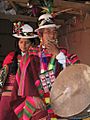
Festival time in Sucre
.jpg)
See also
 In Spanish: Sucre para niños
