
Quito facts for kids
Quick facts for kids
Quito
|
|||
|---|---|---|---|
| San Francisco de Quito | |||
|
Skyline of Quito
A view of Basílica del Voto Nacional
Old town with El Panecillo in the background
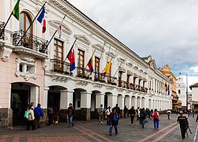
Independence Square
|
|||
|
|||
| Nicknames:
Carita de Dios (Little Face of God), Mitad del Mundo (Middle of the World), Luz de América (Light of the Americas)
|
|||

Quito
Location in Ecuador

Quito
Location in South America
|
|||
| Country | |||
| Province | |||
| Canton | Metropolitan District of Quito | ||
| Spanish foundation | 6 December 1534 | ||
| Founded by | Sebastián de Benalcázar | ||
| Named for | Quitu | ||
| Urban parishes | 32 urban parishes | ||
| Government | |||
| • Type | Mayor and council | ||
| Area
(approx.)
|
|||
| • Capital city | 197.5 km2 (76.3 sq mi) | ||
| • Metro | 4,217.95 km2 (1,628.56 sq mi) | ||
| Elevation | 2,850 m (9,350 ft) | ||
| Population
(2022)
|
|||
| • Capital city | 1,763,275 | ||
| • Density | 8,928.0/km2 (23,123/sq mi) | ||
| • Metro | 2,889,703 | ||
| • Metro density | 685.0966/km2 (1,774.3919/sq mi) | ||
| • Demonym | Quiteño | ||
| GDP (PPP, constant 2015 values) | |||
| • Year | 2023 | ||
| • Total | $33.9 billion | ||
| • Per capita | $13,600 | ||
| Time zone | UTC−5 (ECT) | ||
| Postal code |
EC170150
|
||
| Area code(s) | (0)2 | ||
| Languages | Spanish | ||
| Climate | Cfb | ||
| Official name: City of Quito | |||
| Type: | Cultural | ||
| Criteria: | ii, iv | ||
| Designated: | 1978 (2nd session) | ||
| Reference #: | 2 | ||
| Region: | Latin America and the Caribbean | ||


_Historic_Center_of_Quito,_pic.bb2633.jpg)


Quito (Spanish pronunciation: [ˈkito]; Quechua: Kitu), officially San Francisco de Quito, is the capital of Ecuador. It has about 2.8 million people living in its wider metropolitan area. Quito is also the capital of the Pichincha region. The city sits in a valley on the eastern side of Pichincha, an active stratovolcano (a cone-shaped volcano built up by many layers of hardened lava and ash) in the Andes mountains.
Quito is very high up, at about 2,850 meters (9,350 feet) above sea level. This makes it one of the highest capital cities in the world. It is either the highest or second highest, depending on whether La Paz or Sucre is considered the main capital of Bolivia.
Quito is the main center for government and culture in Ecuador. Many important government offices and cultural places are in the city. Most big international companies in Ecuador have their main offices here. Quito is also one of the country's two major industrial areas. The other is the port city of Guayaquil.
People have lived in this area for a very long time, possibly as far back as 4400 BC. In the late 1400s, the Inca Emperor Huayna Capac took over the area from the Quitu people. He made Quito the capital of the Inca Empire's northern part. The Spanish officially founded the city in 1534. This makes Quito the oldest capital city in South America.
Quito's historic center is one of the largest and best-preserved old towns in the Americas. In 1978, UNESCO named Quito and Kraków as the first ever World Cultural Heritage Sites. Quito is also the capital city closest to the Equator. The Equator line actually runs through the northern part of the city's area, in a place called San Antonio.
Contents
History of Quito
Early History of Quito
The first signs of people living in the Quito area were found in 1960. Tools made of obsidian glass, dating back to 8000 BC, were found on the slopes of the Ilaló volcano. This shows that hunter-gatherers lived here a very long time ago.
Another important early settlement was found in the Cotocollao area (around 1500 BC). This ancient village was quite large and had rectangular houses. People from Cotocollao traded obsidian with other regions.
Some old stories talk about a "Kingdom of Quito" ruled by the Quitu or Cara people. However, modern archaeologists and historians believe that the region was likely made up of many different groups, not one big kingdom. The local Quitu tribe had their own unique art and buildings. Recent discoveries of 20-meter deep tombs from around 800 AD show how skilled the Quitu people were and how complex their burial customs were. In 2010, the Museo de Sitio La Florida opened to protect these amazing finds.
Colonial Times in Quito


The Spanish arrived in 1534. Diego de Almagro founded a city called Santiago de Quito on August 15, 1534. It was later renamed San Francisco de Quito on August 28, 1534. The city was then officially refounded in its current spot on December 6, 1534, by Sebastián de Benalcázar. He captured the Inca leader Rumiñahui, which ended the local resistance.
On March 28, 1541, Quito became a city. In 1563, it became an important administrative district for Spain, called a Real Audiencia. This district was part of the Viceroyalty of Peru and later the Viceroyalty of New Granada.
The Spanish brought Roman Catholicism to Quito. The first church was built even before the city was officially founded. In January 1535, the San Francisco Convent was built. This was the first of about 20 churches and convents built during the colonial period. The Spanish used local people to help build these structures.
By 1743, Quito had about 10,000 people. On August 10, 1809, people in Quito started a movement to gain independence from Spain. This first attempt was stopped on August 2, 1810, when Spanish troops arrived and many leaders were killed. The fight for independence continued. On May 24, 1822, Antonio José de Sucre, under Simón Bolívar, led troops to victory in the Battle of Pichincha. This battle, fought on the slopes of the volcano, won independence for Quito and the surrounding areas.
Quito in Modern Ecuador

_-_Entrada_en_la_ciudad_de_Quito_de_las_tropas_espanolas_remitidas_por_el_Virrey_del_Per%C3%BA_en_1809_-_Museo_de_Am%C3%A9rica_2010-04-01_(cropped)1.jpg)
,_%C3%B3leo_sobre_lienzo_atribuido_a_Rafael_Salas_Estrada_en_el_MUNA,_Quito.jpg)
After independence, Ecuador faced some challenges. In 1833, some people who were against the government were killed. In 1845, the Marcist Revolution began. Later, in 1875, the country's president, Gabriel García Moreno, was killed in Quito.
In 1882, people rebelled against the ruler Ignacio de Veintimilla. In 1895, Eloy Alfaro became president. He worked to bring changes to the country.
In 2011, Quito had over 2.2 million people. The city has been working to improve its historic center since 2002. The old airport, which was built on a filled-in lagoon, closed in 2013. This area was turned into a large park called "Parque Bicentenario". A new airport, Mariscal Sucre International Airport, opened in 2013, about 45 minutes from the city center.
The city has also improved its public transport. Bus lines were built in 2003 and 2004. Many roads were made wider to help traffic flow better. A new subway system opened on December 1, 2023, making it easier to travel across the city.
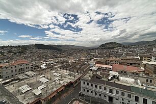
Geography of Quito

Quito is in the northern highlands of Ecuador. It is located in the Guayllabamba river basin. The city is built on a long, flat area on the eastern side of the Pichincha volcano. The valley where Quito lies is surrounded by volcanoes. Some of these volcanoes have snow-capped peaks and can be seen from the city on a clear day. Quito is the capital city closest to the equator. Its altitude is about 2,820 meters (9,252 feet).
Volcanoes Near Quito
Quito's closest volcano is Pichincha, which stands over the city's western side. Quito is the only capital city built so close to an active volcano. Pichincha has several peaks, including Ruku Pichincha (4,700 meters / 15,420 feet) and Guagua Pichincha (4,794 meters / 15,728 feet).
Pichincha is active, and scientists at the national polytechnic university watch it closely. The biggest eruption happened in 1660, when more than 25 centimeters (10 inches) of ash covered the city. The most recent eruption was on October 5, 1999, when some smoke and ash were seen.
Other nearby volcanoes can also affect Quito. In November 2002, the Reventador volcano erupted, covering the city in fine ash.
To the east of Quito, in the Central Cordillera mountains, are volcanoes like Cotopaxi, Sincholagua, Antisana, and Cayambe. To the west, in the Western Cordillera, are volcanoes such as Illiniza, Atacazo, and Pululahua. Pululahua is special because its caldera (crater) is home to people.
Quito's Climate
Quito has a cool, constant climate due to its high altitude and location on the equator. The average afternoon temperature is about 21.4°C (70.5°F), and the average night temperature is about 9.8°C (49.6°F). The average yearly temperature is 15.6°C (60.1°F).
The city has two main seasons:
- Dry season: June through August (called summer).
- Wet season: September through May (called winter).
Quito gets a lot of sunlight, sometimes reaching a very high UV Index of 24. This is because it is so close to the equator and high up.
| Climate data for Quito, elevation 2,812 m (9,226 ft), (1981–2010) | |||||||||||||
|---|---|---|---|---|---|---|---|---|---|---|---|---|---|
| Month | Jan | Feb | Mar | Apr | May | Jun | Jul | Aug | Sep | Oct | Nov | Dec | Year |
| Record high °C (°F) | 33.0 (91.4) |
28.6 (83.5) |
32.0 (89.6) |
25.6 (78.1) |
30.4 (86.7) |
29.0 (84.2) |
31.0 (87.8) |
27.0 (80.6) |
29.0 (84.2) |
27.0 (80.6) |
29.3 (84.7) |
29.0 (84.2) |
33.0 (91.4) |
| Mean daily maximum °C (°F) | 21.2 (70.2) |
21.0 (69.8) |
20.8 (69.4) |
20.9 (69.6) |
21.0 (69.8) |
21.1 (70.0) |
21.5 (70.7) |
22.2 (72.0) |
22.3 (72.1) |
21.8 (71.2) |
21.3 (70.3) |
21.3 (70.3) |
21.4 (70.5) |
| Daily mean °C (°F) | 15.5 (59.9) |
15.6 (60.1) |
15.5 (59.9) |
15.6 (60.1) |
15.6 (60.1) |
15.5 (59.9) |
15.5 (59.9) |
15.9 (60.6) |
15.9 (60.6) |
15.7 (60.3) |
15.5 (59.9) |
15.5 (59.9) |
15.6 (60.1) |
| Mean daily minimum °C (°F) | 9.8 (49.6) |
10.1 (50.2) |
10.1 (50.2) |
10.2 (50.4) |
10.1 (50.2) |
9.8 (49.6) |
9.4 (48.9) |
9.6 (49.3) |
9.4 (48.9) |
9.5 (49.1) |
9.6 (49.3) |
9.7 (49.5) |
9.8 (49.6) |
| Record low °C (°F) | 3.0 (37.4) |
4.7 (40.5) |
5.1 (41.2) |
5.3 (41.5) |
2.5 (36.5) |
3.0 (37.4) |
3.0 (37.4) |
2.2 (36.0) |
3.4 (38.1) |
4.2 (39.6) |
2.5 (36.5) |
2.5 (36.5) |
2.2 (36.0) |
| Average precipitation mm (inches) | 82.5 (3.25) |
111.0 (4.37) |
146.6 (5.77) |
171.2 (6.74) |
105.5 (4.15) |
39.5 (1.56) |
21.5 (0.85) |
27.7 (1.09) |
68.9 (2.71) |
114.9 (4.52) |
108.5 (4.27) |
100.4 (3.95) |
1,098.2 (43.24) |
| Average precipitation days (≥ 1.0 mm) | 10 | 11 | 15 | 15 | 13 | 7 | 5 | 5 | 11 | 14 | 11 | 11 | 128 |
| Average relative humidity (%) | 80 | 81 | 82 | 82 | 80 | 75 | 67 | 65 | 70 | 79 | 79 | 79 | 77 |
| Mean monthly sunshine hours | 197 | 140 | 122 | 136 | 164 | 189 | 249 | 256 | 196 | 177 | 197 | 215 | 2,238 |
| Source 1: World Meteorological Organization | |||||||||||||
| Source 2: Voodoo Skies (records), Danish Meteorological Institute (sun and humidity) | |||||||||||||
| Climate data for Quito | |||||||||||||
|---|---|---|---|---|---|---|---|---|---|---|---|---|---|
| Month | Jan | Feb | Mar | Apr | May | Jun | Jul | Aug | Sep | Oct | Nov | Dec | Year |
| Mean daily daylight hours | 12.0 | 12.0 | 12.0 | 12.0 | 12.0 | 12.0 | 12.0 | 12.0 | 12.0 | 12.0 | 12.0 | 12.0 | 12.0 |
| Average Ultraviolet index | 11+ | 11+ | 11+ | 11+ | 11+ | 11+ | 11+ | 11+ | 11+ | 11+ | 11+ | 11+ | 11 |
| Source: Weather Atlas | |||||||||||||
Quito's City Zones

Quito is divided into three main areas, separated by hills:
- Central: This is where the colonial old city is located.
- Southern: This area is mostly for factories and homes for working-class families.
- Northern: This is the modern part of Quito. It has tall buildings, shopping malls, the financial district, and homes for different income levels.
Quito's Economy
Quito contributes the most to Ecuador's national economy. It also has the highest income per person. The city collects more taxes than any other part of Ecuador, making it the country's most important economic region.
The main industries in Quito are textiles (making fabrics), metals, and agriculture. Important crops grown for export include coffee, sugar, cacao, rice, bananas, and palm oil.
Petroecuador, the largest company in Ecuador, has its main office in Quito. Many national and international banks, oil companies, and businesses also have their headquarters or regional offices here. This makes Quito a major business city in the world.
Getting Around Quito
Public Transportation in Quito
The MetrobusQ network is Quito's fast bus system. It runs through the city from south to north. It has three main lines: the green line (El Trole), the red line (Ecovía), and the blue line (Central Corridor). Besides this system, many other bus companies operate in the city. Taxis are yellow and use meters to show the fare. There are nearly 8,800 registered taxis.
In 2012, Quito started a city-wide bicycle sharing system called Bici Q. A new system was launched in 2023 to encourage more people to use bicycles. This helps reduce travel times, air pollution, and improves life for citizens.
Roads and Highways in Quito
Even though public transport is popular, more people are using private cars. Quito is about 40 kilometers (25 miles) long and 5 kilometers (3 miles) wide. So, most major roads run from north to south. The two main highways are Avenue Oriental on the eastern hills and Avenue Occidental on the western side, near the Pichincha volcano. 10 de Agosto Street also runs north to south through the middle of the city. The historic center has a grid pattern, with important streets like Venezuela, Chile, García Moreno, and Guayaquil.
Air Travel in Quito

The Mariscal Sucre International Airport is Quito's main airport for passengers and cargo. It is about 18 kilometers (11 miles) east of the city center. It opened on February 20, 2013. It replaced the Old Mariscal Sucre International Airport, which was closer to the city. The old airport was closed because tall buildings and fog made it hard for planes to land. The old airport area has been turned into a large city park.
Railways in Quito
There is a railroad that goes through the southern part of Quito, passing through the Estación de Chimbacalle. This railway is now mostly used for tourism.
Quito's Metro System
A 23-kilometer (14-mile) subway system, the Quito Metro, started construction in 2013. It has 15 stations and opened on December 1, 2023. This project cost $1.5 billion and helps carry many passengers each day, connecting to the existing public transport network.
Places to Visit in Quito
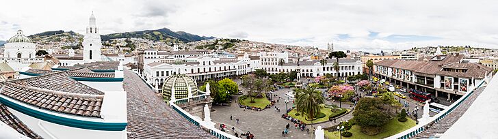
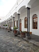
Historic Center of Quito

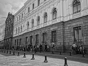
Quito has the largest and best-preserved historic center in the Americas. In 1978, it was one of the first places to be named a World Heritage Site by UNESCO. The historic center is in the south of the city, covering about 320 hectares (790 acres). It has about 130 important buildings, filled with amazing art and sculptures, mostly with religious themes.
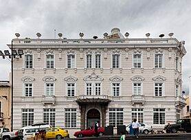
- Palacio de Carondelet
The Palacio de Carondelet is where the President of Ecuador works. It is in the historic center, facing Independence Square, also known as Plaza Grande. This square is also home to the Archbishop's Palace, the Municipal Palace, and the Metropolitan Cathedral. Most presidents of Ecuador have governed from this palace. The president's home is on the third floor.
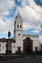
- Basílica del Voto Nacional
The huge Basilica del Voto Nacional is the most important neo-Gothic building in Ecuador. It is one of the most famous in the Americas and was once the largest in the New World.
- Quito Metropolitan Cathedral
The Quito Metropolitan Cathedral is a very important religious building for Catholics in the city. Building this church started in 1535. It was finished in 1799. This cathedral is where the remains of the hero Antonio José de Sucre are buried, along with several presidents and religious leaders. It is on the south side of the Plaza de La Independencia.
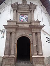
- Church of La Compañía de Jesús
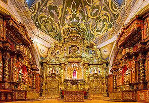
Building The Church of La Compañía began in 1605 and took 160 years to finish. The front of the church was completed in 1765 by Native Americans. They carefully shaped stones to create its beautiful and detailed Baroque style. It is one of the best examples of this art in the Americas.
- Basilica of San Francisco
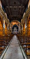
The Basilica of San Francisco is the largest group of buildings in any historic center in Latin America. Construction started in 1550 on land next to a plaza where Native Americans traded goods.
- Church of El Sagrario
In colonial times, the Church of El Sagrario was a great architectural wonder in Quito. It was built in the late 1600s in the Italian Renaissance style. It has beautiful sculptures and decorations. The central arch leads to a dome with paintings of biblical scenes.
- Church of Santo Domingo
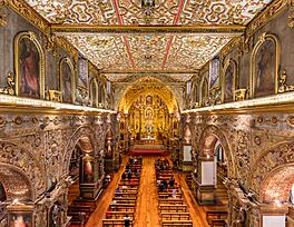
Church of Santo Domingo. The Dominicans started building their church in 1580. It was finished in the early 1600s. Inside, there are valuable structures, like the main altar. The church's roof has paintings of martyrs. The museum next to the church has amazing works by famous Quito sculptors. The Chapel of Nuestra Señora del Rosario, a beautiful Baroque building, is also next to the church.
-
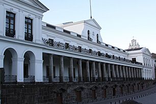
Carondelet Palace, office and house of the Presidents of Ecuador.
-

Quito Metropolitan Cathedral, built between 1535 and 1799.
-
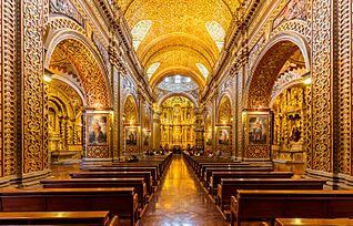
Church of La Compañía de Jesús
-
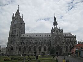
Basílica del Voto Nacional
-
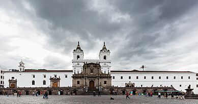
Basilica of San Francisco, built between 1535 and 1650.
-
Interior of the basilica of San Francisco
-
View of the Church of Santo Domingo
-
Interior of the church of Santo Domingo
-
Chapel of the Rosary within the church of Santo Domingo
-
Gangotena Palace
-
Municipal Palace in the Plaza Grande
-
Plaza Grande
-
Centro de Arte Contemporáneo, Quito.
-
Antiguo Hospital Militar (Centro Histórico, Quito)
-
View of Quito from Basílica del Voto Nacional
-
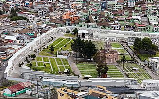
Cemetery of San Diego, Quito

.jpg)


_pic_a05.JPG)


El Panecillo Hill

El Panecillo is a hill in the middle-west of the city. It is about 3,016 meters (9,895 feet) above sea level. A large monument to the Virgin Mary stands on top of El Panecillo. You can see it from most of Quito. The statue is 41 meters (135 feet) tall and was built in 1976. It is a copy of an older sculpture made in 1732.
La Mariscal Area
This modern area is known as the city's entertainment center. It's a popular spot for both locals and tourists. It has many restaurants, art places, cultural events, hotels, shops, bars, and nightclubs that come alive at night. The "Great Parade of Mariscal" happens here during the Fiestas de Quito.
Plaza Foch (La Zona)

This area is considered the "zona rosa" (pink zone) of the city, meaning it's a lively nightlife spot. It has many nightclubs and bars, especially from Thursday to Saturday. It's popular with tourists from all over the world. Because of its small streets and wide sidewalks, it's mostly a place for walking.
Parks in Quito
Metropolitano Park
Parque Metropolitano Guanguiltagua is the largest urban park in South America. It covers about 1,376 acres (5.57 square kilometers). To compare, New York's Central Park is 843 acres. The park is in northern Quito, on the Bellavista hill. It's great for mountain biking, walking, and running. Most of it is a forest with trails. You can also find sculptures there. The park has picnic areas, and from the eastern part, you can see volcanoes like Cotopaxi and Antisana.
Bicentenario Park
Parque Bicentenario is Quito's second-largest urban park. It is located where the Old Mariscal Sucre International Airport used to be. It opened on April 27, 2013. This park is 200 acres (0.81 square kilometers) and is about 2,800 meters (9,186 feet) above sea level. The old runway is now a recreational space with lanes for bicycles and walkers. There are play areas for children and exercise equipment for adults. The park also has a pond and many trees. It hosts cultural events and outdoor concerts.
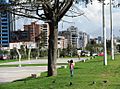
La Carolina Park

La Carolina is a 165.5-acre (0.67 square kilometers) park in the center of Quito's main business area. It is surrounded by major avenues. The park was created in 1939. Pope John Paul II held a large mass here during his visit to Ecuador in 1985. A giant cross has been built in this spot.
El Ejido Park
El Ejido is Quito's fourth-largest park. It separates the old part of the city from the modern part. This park is famous for its handicrafts market every Saturday and Sunday. You can find local painters selling copies of famous artworks. Otavaleños sell traditional sweaters, ponchos, carpets, and jewelry.
Guápulo Area
Guápulo is a district of Quito, located on the side of a cliff. It offers views of the valley and, in the distance, the Amazon Jungle. This neighborhood is known as an artsy, bohemian area with many local artists and cafes. Every year on September 7, the people of Guápulo celebrate their neighborhood with the Fiestas de Guápulo. This is a lively celebration with costumes, parades, food, music, dance, and fireworks.
La Alameda Park
The long, triangular La Alameda park is at the beginning of Guayaquil Street, where the historic center starts. It has an impressive monument of Simón Bolívar. In the center of the park is the Quito Observatory, which opened in 1873. It is used for studying weather and stars. At the north end of the park, there are two lakes where you can rent rowboats.
La Floresta Neighborhood
La Floresta is one of the city's most well-known neighborhoods. It offers a rich cultural and food scene. The area has local and international restaurants, a cinema, small theaters, cafes, bars, museums, and co-working spaces.
-
La Circasiana door, currently at the north end of El Ejido park. Originally the entrance door to the Circasiana Palace in La Mariscal neighborhood.
-
Astronomic observatory in the Alameda park
-
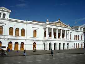
Sucre National Theatre


TeleferiQo Cable Car

Since July 2005, Quito has had a cable car system called the "Telefériqo". It goes from the city center up to Cruz Loma, a part of the Pichincha mountain. The ride takes visitors to an elevation of about 4,100 meters (13,451 feet). From there, you can hike trails and take pictures of Quito. It is much cooler at the top due to the higher elevation and wind.
The Telefériqo area also includes an amusement park (Vulqano Park), restaurants, Go Karts, Paint Ball, shopping areas, and other fun attractions.
Attractions Outside the City

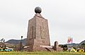
La Mitad del Mundo (meaning "the middle of the world") is a small village about 35 kilometers (22 miles) north of Quito. It has a monument marking the Equator. However, modern GPS technology shows the actual Equator is about 240 meters (787 feet) north of the monument. Nearby is the Intiñan Solar Museum, which might be closer to the true Equator.
The Pululahua Geobotanical Reserve, a few miles northwest of La Mitad del Mundo, has the Pululahua volcano. Its caldera (crater) can be seen from a viewpoint and is one of the few in the world where people live.
The Quito Zoo is located near Guayllabamba, about 20 kilometers (12 miles) outside Quito. It has the largest collection of native animals in Ecuador. The zoo works to protect animals and educate people. It has successfully bred the endangered Andean condor.
The Maquipucuna Reserve is a large rainforest and cloud forest reserve. It protects many plant and bird species. This reserve is important for the conservation of the spectacled bear (Andean bear). You can sometimes see these bears at an ecolodge in the reserve.
Other natural attractions near Quito include:
- Bellavista Cloud Forest Reserve (for conservation and bird watching)
- Cayambe – Coca Ecological Reserve (with thermal springs)
- Cotopaxi National Park
- Mindo Nambillo cloud forest
- Illiniza volcano
- Pasochoa Wildlife Refuge
- Pichincha volcano (with its peaks Wawa Pichincha and Ruku Pichincha)
Quito's Culture
Quito blends modern and traditional culture. The city has a strong Catholic presence. Holy Week is celebrated with many ceremonies and rituals. On Good Friday, the March of the Penitents takes place, starting from the Church of San Francisco.
Education in Quito
.jpg)
Universities in Quito
Quito is home to many universities. Some of the oldest and most well-known include:
- Central University of Ecuador (founded 1826)
- National Polytechnic School (founded 1869)
- Pontifical Catholic University of Ecuador (founded 1946)
- Universidad San Francisco de Quito (founded 1988)
Libraries in Quito
One of the oldest and most important libraries in Ecuador is the Central University Library in Quito. It was founded in 1586 and has 170,000 books. Other important libraries include the Aurelio Espinoza Polit, Casas de la Cultura, and the Catholic University libraries.
Museums in Quito

- National Museum of Ecuador – This art museum has five displays. Each covers a different time period, from prehistory to modern Ecuador.
- Museo de Arte Contemporaneas – Located north of Basilica del Voto Nacional, this museum has permanent and temporary art shows. The building used to be a military hospital.
- Casa del Alabado – This museum is just south of Plaza San Francisco. It is the Old Town's newest museum and displays art from before the Spanish arrived. The building is one of the oldest houses in the city.
- Museo de la Ciudad – This museum tells the history of Quito. It is located east of Plaza de Santo Domingo, in the buildings of the old San Juan de Dios Hospital.
- La Capilla del Hombre – A museum showing the work of the famous Ecuadorian artist Oswaldo Guayasamín.
- Ecuador National Museum of Medicine – This museum is about the history of medicine in Quito. It was founded by Eduardo Estrella Aguirre.
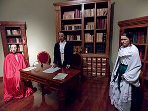
- Museum House of Sucre – This museum is dedicated to the life of Mariscal Antonio José de Sucre, a hero of Ecuador's independence. The ground floor has weapons and military items. The second floor shows what his home might have looked like.
-
Quito Colonial Art Museum
-
Centro Cultural Metropolitano
-
Alberto Mena Caamaño Museum
.jpg)

.JPG)
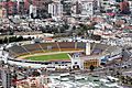
Sports in Quito
.jpg)
Quito is home to many important football (soccer) clubs. The city's top clubs, like LDU Quito, El Nacional, Deportivo Quito, Aucas, and Independiente del Valle, have won many national championships.
Quito is the only city in Ecuador with clubs that have won major international titles. LDU Quito is the only Ecuadorian club to win the Copa Libertadores (South America's biggest club competition), and they have won three other continental titles. Independiente del Valle won the CONMEBOL Sudamericana in 2019 and 2022.
The professional teams in the city are:
- América de Quito
- Aucas
- Deportivo Quito
- El Nacional
- LDU Quito
- Universidad Católica
One interesting fact about Quito is that its stadiums are located over 2,800 meters (9,186 feet) above sea level. This gives local teams a big advantage when playing against teams from lower altitudes. This high altitude is one reason Ecuador has qualified for three World Cups.
Famous People from Quito
- Jorge Carrera Andrade, poet (1902–1978)
- Christian Benítez, professional footballer (1986–2013)
- Polo Carrera, former professional footballer (b. 1945)
- Sebastián Cordero, film director (b. 1972)
- Juan Manuel Correa, racing driver (b. 1999)
- Eugenio Espejo, scientist (1747–1795)
- Oswaldo Guayasamín, painter (1919–1999)
- Jorge Icaza, novelist (1906–1978)
- Manuela Sáenz, revolutionary (1797–1856)
- José Velasco Ibarra, former president of Ecuador (1893–1979)
Quito's Sister Cities
Quito has sister city relationships with these cities:
Images for kids
-
Skyline of Quito
-

A view of Basílica del Voto Nacional
-

Old town with El Panecillo in the background
-

Independence Square
-

Flag of Quito
-
Coat of Arms of Quito
-

View of Quito from the International Space Station
-
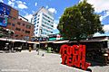
Plaza Foch
-
La Carolina Park next to Amazonas Avenue
-
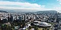
Atahualpa Olympic Stadium
-
The monument at the equator (La Mitad del Mundo)
See also
 In Spanish: Quito para niños
