Cotopaxi facts for kids
Quick facts for kids Cotopaxi |
|
|---|---|
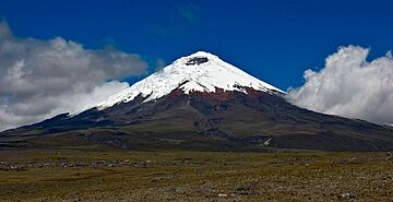
Cotopaxi seen from the high plain (at least 3,700 m (12,139 ft)) of Cotopaxi National Park
|
|
| Highest point | |
| Elevation | 5,897 m (19,347 ft) |
| Prominence | 2,500 m (8,202 ft) |
| Listing | Ultra |
| Geography | |
| Location | Cotopaxi, Latacunga, Ecuador |
| Parent range | Andes |
| Geology | |
| Mountain type | Stratovolcano |
| Last eruption | 2023 (ongoing) |
| Climbing | |
| First ascent | 28 November 1872 by Wilhelm Reiss and Ángel Escobar |
| Easiest route | North side: Glacier/Snow Climb (Grade PD-) |
Cotopaxi is a tall, active stratovolcano in the Andes Mountains of Ecuador. It stands near the city of Latacunga, about 50 kilometers (31 miles) south of Quito. Cotopaxi is the second highest mountain in Ecuador, reaching 5,897 meters (19,347 feet) high. It is also one of the highest active volcanoes on Earth.
Cotopaxi has erupted 87 times throughout history. These eruptions have created many valleys around the volcano with powerful lahars, which are fast-moving mudflows. A new eruption started on October 21, 2022, and is still happening today.
By February 2023, scientists reported that Cotopaxi had caused about 8,000 earthquakes since the eruption began. This means there were around 1,600 earthquakes each month.
Contents
Exploring Cotopaxi's Features
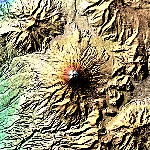
When the weather is clear, you can easily see Cotopaxi from the cities of Latacunga and Quito. It is part of a large group of volcanoes called the Pacific Ring of Fire. This ring circles the Pacific Plate in the ocean. Cotopaxi has a nearly perfect cone shape. It rises from a high plain that is about 3,800 meters (12,500 feet) above sea level. Its base is about 23 kilometers (14 miles) wide.
Cotopaxi is special because it has one of the few glaciers found near the Earth's equator. This ice cap starts at about 5,000 meters (16,400 feet) high. At the very top, Cotopaxi has a large crater. This crater is about 800 by 550 meters (2,600 by 1,800 feet) wide and 250 meters (820 feet) deep. The crater has two parts, one inside the other. The outer part is sometimes free of snow and has an uneven shape. Inside, the crater is covered with ice. The highest point of the volcano is on the northern edge of this outer crater.
Cotopaxi's History
The Meaning Behind the Name
The name Cotopaxi comes from local languages like Quechua. In these languages, coto means 'neck' or 'throat' and paxi means 'moon'. People think this name describes the volcano's crater, which can look like a crescent moon. Long before the Inca Empire arrived in the 1400s, the local Andean people already saw Cotopaxi as a sacred mountain. They believed it sent rain, which helped their crops grow. They also thought the top of the mountain was a home for their gods.
Cotopaxi's Eruptive Past
Cotopaxi is one of Ecuador's most active volcanoes, with 87 known eruptions. The first eruption ever recorded happened in 1534. This event left a layer of ash in lakes, which scientists can still study today.
Some of Cotopaxi's most powerful eruptions happened in 1742, 1744, 1768, and 1877. The eruptions in 1744 and 1768 destroyed the old colonial town of Latacunga. During the eruption on June 26, 1877, hot clouds of ash and gas, called pyroclastic flows, rushed down all sides of the mountain. These flows melted the entire ice cap. This caused huge mudflows, known as lahars, that traveled over 100 kilometers (62 miles). They reached the Pacific Ocean and the western Amazon basin. The city of Latacunga was completely covered by these mudslides once again.
Scientists Pierre Bouguer and Charles-Marie de La Condamine saw the eruption on June 19, 1742. They were part of the French Geodesic Mission and were climbing nearby Guagua Pichincha.
A major eruption took place from 1903 to 1904. Smaller activities continued until at least 1940, and possibly 1942. It can be hard to see small eruptions because of bad weather. In 1975 and 2002, the volcano showed more heat and earthquake activity, but it did not erupt. In 2002, steam vents, called fumaroles, released more sulfur gas. Ice inside and on the southeast side of the cone also began to melt.
In 2015, Cotopaxi became active again. On August 14, two large steam eruptions occurred. These are called phreatic eruptions. In August 2015, 2,100 earthquakes were recorded. The volcano released about 20,000 tons of sulfur dioxide gas each day. The government estimated that about 300,000 people in nearby provinces were at risk from the volcano.
Climbing Cotopaxi's Heights
Many people have tried to climb Cotopaxi. The first European to attempt it was Alexander von Humboldt in 1802, but he only reached about 4,500 meters (14,760 feet). In 1858, Moritz Wagner also tried but did not reach the top.
The first people to successfully reach Cotopaxi's summit were German geologist Wilhelm Reiss and his Colombian partner, Angel Escobar. They made it to the top on November 28, 1872. The next year, in 1873, German geologist Moritz Alphons Stübel and four Ecuadorians also reached the summit. In 1880, British mountaineer Edward Whymper and two Italian guides completed the third recorded climb. They even spent a night at the summit!
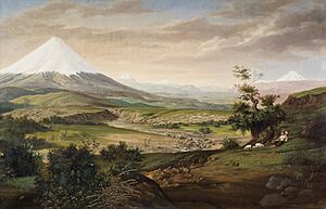
Later, in 1903, painters Rudolf Reschreiter and Hans Meyer also reached the top. Many of Reschreiter's paintings show the beautiful views of Cotopaxi.
Climbing Cotopaxi became very popular for tourists in the late 1900s. The José F. Ribas Refuge is a mountain hut built in 1971 at 4,864 meters (15,958 feet) high. It was made bigger in 2005.
In 1996, on Easter Sunday, a sad event happened. An avalanche of snow and ice partly covered the Refuge and many visitors. An earthquake had likely weakened the glacier above the hut days before. On that warm day, a large part of the ice broke off. Many people visiting the mountain were caught in the snow and ice. Some people inside the Refuge broke windows to escape. Sadly, 13 people died on the slope above the hut. The Refuge is in a valley, which means it can be at risk from avalanches in the future.
Recent Activity and Recreation
Enjoying Cotopaxi's Slopes
Climbing to the summit of Cotopaxi is very popular. Up to 100 climbers might try to reach the top on weekends. When the volcano is quiet, mountain guide companies offer regular guided climbs. The usual climbing route is considered "Mildly Difficult" (alpine PD or WS+). Climbers must use crampons (spikes for boots) and ice axes. They will encounter snow and ice slopes that can be as steep as 50 degrees. Climbers also need to be on belay (connected to a safety rope) and use special ladders to cross deep cracks in the ice, called crevasses.
A special 4WD track goes from the national park entrance up to a parking area. This spot is at 4,600 meters (15,090 feet) high, just below the José F. Ribas Refuge. This stone mountain hut is about 200 meters (650 feet) higher, at 4,800 meters (15,750 feet). It takes about 40-80 minutes to hike up to the hut. Climbers can spend the night here. They usually start their climb to the summit very early in the morning, around 12:30 am. The goal is to reach the top by 7:30 am and return to the hut before the sun melts the snow and makes the glacier more dangerous. Many adventure tourism companies in Quito also offer mountain biking tours down the dirt track from the Refuge.
Understanding Cotopaxi's Eruptions
In April 2015, Cotopaxi began to show signs of waking up. There was a big increase in earthquakes, including harmonic tremors (a type of continuous shaking). The volcano also released more sulfur dioxide gas. Scientists noticed a slight change in the volcano's shape, which suggested that magma (molten rock) was moving underneath it. This activity continued, and on August 14 and 15, 2015, there were significant eruptions of ash and steam. Ash fell heavily near the volcano, damaging farms. A thin layer of ash even reached Quito, affecting the southern and central parts of the city.
A new eruption began on October 21, 2022, and is still ongoing today.
Past eruptions have shown that Cotopaxi's glacier can melt quickly, causing dangerous mudflows called lahars. These lahars would travel down the volcano's sides, following river valleys. The main danger from a large eruption is these powerful lahars, which could affect all river valleys leading from the volcano. If a very large explosion happened, it could impact many towns in the valley near Quito. The city of Latacunga is also in great danger, as it has been destroyed at least twice (in 1768 and 1877) by lahars from Cotopaxi.
Cotopaxi in Art
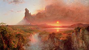
- Cotopaxi is often shown in the traditional paintings of the indigenous people of Tigua. The volcano holds deep cultural meaning for them.
- The famous painter Frederic Edwin Church created important artworks featuring Cotopaxi in 1855 and 1862.
- In the short story The Star (1897) by H. G. Wells, Cotopaxi erupts with lava that reaches the coast in just one day.
- The poem Romance (1916) by Walter J. Turner mentions Cotopaxi as one of the romantic places that captured the poet's heart.
- In the science fiction novel Shadrach in the Furnace (1976) by Robert Silverberg, an eruption of Cotopaxi is called "the night of Cotopaxi." This event starts a series of disasters.
- In the American film Close Encounters of the Third Kind (1977), a ship named the SS Cotopaxi, which disappeared in 1925, appears in the Gobi Desert.
- The American rock band The Mars Volta has a song named after the mountain from 2009.
See also
 In Spanish: Volcán Cotopaxi para niños
- List of volcanoes in Ecuador
- List of volcanic eruptions by death toll
 | Anna J. Cooper |
 | Mary McLeod Bethune |
 | Lillie Mae Bradford |


