
Baños de Agua Santa facts for kids
Quick facts for kids
Baños de Agua Santa
|
||
|---|---|---|
|
City
|
||

Baños from the east
|
||
|
||
| Nickname(s):
Baños
|
||

Baños de Agua Santa
Location in Ecuador
|
||
| Country | Ecuador | |
| Province | Tungurahua | |
| Canton | Baños | |
| Government | ||
| • Type | Mayor and council | |
| Area | ||
| • City | 4.16 km2 (1.61 sq mi) | |
| Elevation | 1,820 m (5,971 ft) | |
| Population
(2022 census)
|
||
| • City | 14,100 | |
| • Density | 3,389/km2 (8,780/sq mi) | |
| Demonym(s) | Baneño(-a) | |
| Time zone | UTC-5 (ECT) | |
| Area code(s) | (0)3 | |
| Climate | Cfb | |

Baños de Agua Santa, often called Baños, is a lively city in the eastern part of Tungurahua Province in Ecuador. It's the second largest city in Tungurahua, after Ambato. Baños is a very popular place for tourists to visit.
People call Baños the "Gateway to the Amazon". This is because it's the last city you'll find in the mountain region before the land changes into the thick jungle of the Amazon River basin. The city is located about 1,820 meters (5,971 feet) above sea level. It sits at the base of the Tungurahua volcano. This volcano is active and sometimes has big ash explosions and lava flows that you can see from Baños.
Contents
What's in a Name?

The full name, Baños de Agua Santa, means "Baths of Holy Water" in Spanish. The city got this name because of its special hot springs. These springs have warm water that comes from underground. Many people believe the minerals in the water have healing powers.
A Look Back in Time
Baños is also an important place for Catholic believers. Some people say that the Virgin Mary appeared near a waterfall close to the city. Because of this belief, a statue of the Virgin, known as Virgen de Agua Santa, was placed in the city's main cathedral.
The city's history is closely connected to the active Tungurahua volcano. In October 1999, everyone living in Baños, over 17,000 people, had to leave the city for several weeks because of the volcano's activity. This shows how important it is to be safe when living near an active volcano.
Exploring the Area
Baños is located at the northern base of the Tungurahua volcano. It's a great starting point for adventures. Along with the town of Pillaro, Baños is known as a good place to begin exploring the remote Llanganates National Park. This park has many interesting sights, including Cerro Hermoso.
In the city center, you'll find a main park right across from the cathedral. Baños is also famous for its many beautiful waterfalls. Some of the well-known ones include Virgen de Agua Santa, Inés María, Agoyán, El Manto de la Novia, Pailón del Diablo, and Machay.
Fun and Economy
Baños is a very popular place for tourists in Ecuador. This is because of its amazing natural surroundings, which include more than 60 waterfalls! It's also a hub for exciting adventure sports. Both locals and visitors love to try activities like rafting, kayaking, canyoning (which is like waterfall climbing), bridge jumping, hiking, biking, and horseback riding.
The city is also known for its delicious taffy, called melcocha in Spanish. This sweet treat is made from sugarcane. You can also find small shops selling beautiful parrot sculptures. These sculptures are carved from light balsa wood.
Weather in Baños
Baños has a type of climate called a subtropical highland climate. This means it has mild temperatures all year round, without extreme heat or cold. It also gets a good amount of rain.
| Climate data for Baños de Agua Santa, elevation 1,843 m (6,047 ft), (1971–2000) | |||||||||||||
|---|---|---|---|---|---|---|---|---|---|---|---|---|---|
| Month | Jan | Feb | Mar | Apr | May | Jun | Jul | Aug | Sep | Oct | Nov | Dec | Year |
| Mean daily maximum °C (°F) | 22.2 (72.0) |
22.3 (72.1) |
22.3 (72.1) |
22.3 (72.1) |
22.2 (72.0) |
21.4 (70.5) |
20.7 (69.3) |
21.2 (70.2) |
22.0 (71.6) |
22.7 (72.9) |
23.2 (73.8) |
22.7 (72.9) |
22.1 (71.8) |
| Mean daily minimum °C (°F) | 13.0 (55.4) |
13.1 (55.6) |
13.2 (55.8) |
13.2 (55.8) |
13.1 (55.6) |
12.4 (54.3) |
11.9 (53.4) |
11.8 (53.2) |
11.9 (53.4) |
12.6 (54.7) |
12.8 (55.0) |
12.8 (55.0) |
12.7 (54.8) |
| Average precipitation mm (inches) | 76.0 (2.99) |
81.0 (3.19) |
103.0 (4.06) |
120.0 (4.72) |
140.0 (5.51) |
208.0 (8.19) |
190.0 (7.48) |
162.0 (6.38) |
136.0 (5.35) |
98.0 (3.86) |
66.0 (2.60) |
67.0 (2.64) |
1,447 (56.97) |
| Average relative humidity (%) | 83 | 82 | 84 | 83 | 85 | 86 | 86 | 84 | 82 | 81 | 79 | 81 | 83 |
| Source: FAO | |||||||||||||
Gallery
-
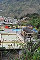
Thermal baths in Baños
-
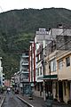
A street in Baños de Agua Santa
-
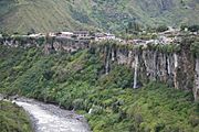
The north side of Baños
-
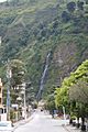
Another street view in Baños (2009)

.jpg)
.jpg)
.jpg)
See also
 In Spanish: Baños (Ecuador) para niños
