Tungurahua Province facts for kids
Quick facts for kids
Tungurahua
|
|||
|---|---|---|---|
|
Province
|
|||
| Province of Tungurahua | |||

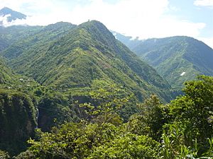
Landscape near Baños
|
|||
|
|||

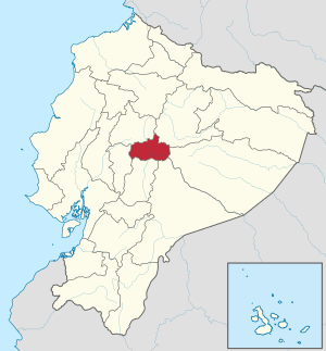
Tungurahua Province in Ecuador
|
|||

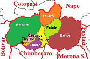
Cantons of Tungurahua Province
|
|||
| Country | Ecuador | ||
| Capital | Ambato | ||
| Cantons |
List of cantons
Ambato
Baños de Agua Santa Cevallos Mocha Patate Quero San Pedro de Pelileo Santiago de Pillaro Tisaleo |
||
| Area | |||
| • Total | 3,386.25 km2 (1,307.44 sq mi) | ||
| Elevation | 2,600 m (8,500 ft) | ||
| Highest elevation | 5,016 m (16,457 ft) | ||
| Lowest elevation | 900 m (3,000 ft) | ||
| Population
(2011)INEC decadal national census
|
|||
| • Total | 581,389 | ||
| • Density | 171.6911/km2 (444.6779/sq mi) | ||
| Time zone | UTC-5 (ECT) | ||
| Vehicle registration | T | ||
| HDI (2017) | 0.768 high · 4th |
||
Tungurahua is one of the 24 provinces of Ecuador. It is located in the central part of the country. The province is named after the famous Tungurahua volcano. Its capital city is Ambato.
Contents
About Tungurahua Province
Tungurahua is a beautiful region in Ecuador. It is known for its mountains, valleys, and rivers. The province is home to many different plants and animals. People often visit for its natural beauty and outdoor activities.
Geography and Location
Tungurahua is in the Andes mountains. This means it has a lot of high peaks and deep valleys. The lowest parts are around 900 meters (2,950 feet) above sea level. The highest point is the Tungurahua volcano, which reaches 5,016 meters (16,457 feet).
People and Population
In 2011, about 581,389 people lived in Tungurahua. Most people live in the capital city, Ambato. The province is a mix of different cultures. Many people work in farming or in small businesses.
Government and Leadership
Each province in Ecuador has a leader called a Prefect. The Prefect helps manage the province. In Tungurahua, the Provincial Prefect is Fernando Naranjo. He works to improve the lives of people in the province.
Cantons of Tungurahua
Tungurahua province is divided into smaller areas called cantons. Think of cantons like counties or districts. There are nine cantons in Tungurahua:
- Ambato
- Baños de Agua Santa
- Cevallos
- Mocha
- Patate
- Quero
- San Pedro de Pelileo
- Santiago de Pillaro
- Tisaleo
Each canton has its own local government.
The Tungurahua Volcano
The province gets its name from the Tungurahua volcano. It is an active volcano. This means it can erupt sometimes. The volcano is a major landmark in the area. It is also a popular spot for hikers and nature lovers.
See also

- Learn more about Tungurahua in Spanish: Provincia de Tungurahua para niños
 | Roy Wilkins |
 | John Lewis |
 | Linda Carol Brown |


