Cushendall facts for kids
Quick facts for kids Cushendall
|
|
|---|---|
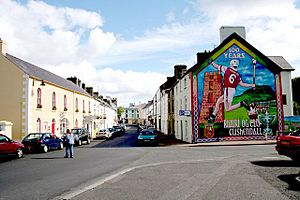
 Cushendall village with hurling mural |
|
| Population | 1,280 (2011 Census) |
| District |
|
| County | |
| Country | Northern Ireland |
| Sovereign state | United Kingdom |
| Post town | BALLYMENA |
| Postcode district | BT44 |
| Dialling code | 044 |
| EU Parliament | Northern Ireland |
| UK Parliament |
|
| NI Assembly |
|
Cushendall (from Irish: Cois Abhann Dalla, meaning "foot of the River Dall"), once called Newtownglens, is a village on the coast in County Antrim, Northern Ireland. It is a small area of land called a townland (about 153 acres). The village is part of the Causeway Coast and Glens district.
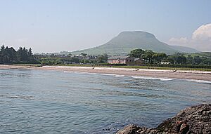
Cushendall is found on the A2 coast road. It lies between Glenariff and Cushendun. This area is known as the Antrim Coast and Glens. It is a special place called an Area of Outstanding Natural Beauty. The village sits near the flat-topped Lurigethan Mountain. It is also where three of the famous Glens of Antrim meet: Glenaan, Glenballyemon, and Glencorp. The coast here is close to Scotland. The Mull of Kintyre is only about 16 miles away. In 2011, Cushendall had a population of 1,280 people.
Many old buildings from the 1800s are still in Cushendall. These include the Irish Georgian style buildings on the town's four main streets. In 1973, Cushendall became the second village in Northern Ireland to be a Conservation Area. This means its historic look is protected. Since 1990, Cushendall has held the Heart Of The Glens festival every August. Thomas D'Arcy McGee, who helped create Canada, lived here as a child. His father worked for the Coast Guard Service in Cushendall.
Contents
Explore Cushendall: Places to Visit
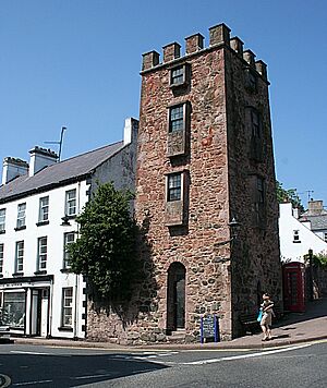
The Curfew Tower
The Curfew Tower is in the middle of Cushendall village. It was built in 1817 by Francis Turnley. He was the landlord of the town at that time. The tower was made to hold prisoners who were causing trouble. An army pensioner named Dan McBride was the guard. He had a musket, a bayonet, pistols, and a long pike. Today, the tower is owned by Scottish musician and artist Bill Drummond.
Oisin's Grave
Oisin's Grave is located off the main road from Cushendall to Ballymoney. It is a very old stone structure called a megalithic court cairn. It sits on a hillside in Lubitavish, near the Glenann River. People believe it is the burial place of Oisín. He was a famous Celtic warrior poet. In 1989, a stone cairn was built there. It remembers John Harold Hewitt, a poet from the Glens.
Layd Church and Churchyard
The old ruins of Layd Church are about 1.5 km north of Cushendall. This church was started by Franciscan monks. Parts of it might be from the 1200s. You can reach the ruins by road or by a path along the cliffs from Cushendall. There are old burial vaults in the churchyard. It was a main burial place for the MacDonnells family.
There is a stone cross memorial here. It honors Dr James MacDonnell. He helped organize the last Belfast Festival of Harpists in 1792. He also helped start using chloroform in surgery. Near the churchyard gate is a special 'holestone'. Close by are two 'corp stones' where coffins were placed. Layd Church was used as a parish church from 1306 until about 1790.
Red Bay Castle
Red Bay Castle is located between Cushendall and Waterfoot villages. The Bisset family built it in the 1300s. Later, the MacDonnells lived there. It was one of the outposts of the ancient Kingdom of Dál Riata.
Glenariff Forest Park
Glenariff Forest Park is about 8 km inland from Cushendall. This large park covers 1185 hectares (about 2900 acres). The park has beautiful waterfalls and forest trails. You can also enjoy walks along the river. There is a café, toilets, and an exhibition centre. Four marked trails let you explore the forest. They range from 1 km to 9 km long.
Cushendall's Past: A Look at History
Cushendall has seen some challenging times in its history. During a period known as The Troubles in the early 1920s, an incident occurred. On June 23, 1922, several lorries of police and soldiers came to Cushendall. They were there to make sure people followed the nightly curfew. During this time, three local men died. The police said they were attacked, but a later government investigation found this was not true.
There were also other difficult incidents during the Troubles in the late 1900s. These events show how much the area has changed and grown since then.
Who Lives in Cushendall: Demographics
Cushendall is officially called a village. This means it has between 1,000 and 2,499 people. On March 27, 2011, the population of Cushendall was 1,280. This was about 0.07% of Northern Ireland's total population.
Here's a quick look at the people living there:
- About 21% were under 16 years old.
- About 15% were 65 years old or older.
- Almost 50% of the people were male.
- A little over 50% were female.
- Most people (about 92%) were from a Catholic background.
- About 6% were from a Protestant or other Christian background.
Sports and Activities in Cushendall
Hurling
Ruairí Óg is the local hurling club. It was started in 1906. They play their home games at Páirc Mhuire in Cushendall. Hurling is a fast-paced Irish sport. The club first became Ulster champions in the 1981-82 season. They have won the Ulster championship 11 times as of 2022. They reached the final of the All-Ireland Senior Club Hurling Championship once in 2015-16. They lost to Na Piarsaigh from Limerick in that game.
Golf
Cushendall Golf Club has a small nine-hole course. It is a good place to practice your short game. The course is in a valley. The Abhainn Dala (River Dall) runs through its middle on its way to the sea.
Sailing
Cushendall Sailing & Boating Club started in 1951. It is a great place to learn sailing skills. The club is in Red Bay. The views of the surrounding Glens of Antrim are amazing. They make a beautiful background for sailing. The club has a sailing school in the summer. It uses the RYA's learn-to-sail program. The school welcomes all ages and skill levels.
Running
The Lurig Run happens every year. It is on the second Saturday of August during the Heart of the Glens Festival. This challenging run is 3.5 miles long. It includes a 1500-foot climb up the side of the Lurigethan mountain. It is very popular among runners. Many see it as one of the toughest organized runs in Northern Ireland. About 400 people compete each year.
Visiting Cushendall: Tourism
You can find many places to stay in Cushendall. These include self-catering homes, Bed & Breakfasts, and caravan and camping sites. Cushendall has three caravan and camping sites.
The village has many shops. You can find local gifts and crafts there. They also sell many other items.
Cushendall also hosts an annual vintage car rally. Old cars gather in the village for this event.
Famous People from Cushendall
See also
 In Spanish: Cushendall para niños
 | James B. Knighten |
 | Azellia White |
 | Willa Brown |


