Lisburn facts for kids
Quick facts for kids Lisburn
|
|
|---|---|
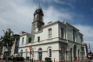
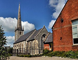
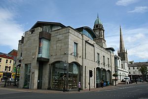 Irish Linen Museum and Christ Church Cathedral |
|
| Population | (2021 Census)
|
| • Belfast | 8 miles |
| District |
|
| County | |
| Country | Northern Ireland |
| Sovereign state | United Kingdom |
| Post town | LISBURN |
| Postcode district | BT27, BT28 |
| Dialling code | 028 |
| Police | Northern Ireland |
| Fire | Northern Ireland |
| Ambulance | Northern Ireland |
| EU Parliament | Northern Ireland |
| UK Parliament |
|
| NI Assembly |
|
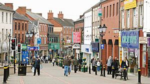
Lisburn is a city in Northern Ireland. It is about 8 miles (13 km) southwest of Belfast. The city sits on the River Lagan, which divides County Antrim and County Down.
Lisburn was first planned in the 1600s by settlers from England and Wales. Later, in the 1700s, French Huguenots arrived. They helped the town grow into a major hub for the linen industry around the world.
In 2002, Lisburn was given city status by Queen Elizabeth during her Golden Jubilee. This happened at the same time as the town of Newry also became a city. In 2021, Lisburn had a population of 51,447 people.
Contents
What Does the Name Lisburn Mean?
The town was first called Lisnagarvy. This name came from the Irish words Lios na gCearrbhach, which means 'ringfort of the gamesters' or 'gamblers'. A ringfort was a type of ancient fort.
The reason for the name Lisburn is not fully clear. The name Lisburn first appeared in church records in January 1662. After February 1662, the old name Lisnagarvy was no longer used.
Many people think the town was renamed after it was burned down during the Irish Rebellion of 1641. However, some historians believe the name Lisburn might have existed even before the fire. It is thought that there might have been two ringforts in the area: Lisnagarvy to the north and Lisburn to the south. Lisburn was shorter and easier for the English settlers to say, so it became the common name.
The original name, Lisnagarvy, is still used today by some local schools and sports teams.
A Look Back at Lisburn's History
Lisburn's first settlement was a fort located north of what is now Wallace Park. In 1609, King James I gave land in County Antrim to Sir Fulke Conway, a Welshman.
How Lisburn Was Built
During the 1620s, the streets of Lisburn were laid out just as they are today. These included Market Square, Bridge Street, Castle Street, and Bow Street. Sir Fulke Conway brought many English and Welsh settlers to the area. He also built a large house, called a manor house, where Castle Gardens is now. In 1623, a church was built on the site of the current cathedral.
In 1628, Sir Edward Conway, Sir Fulke's brother, received permission from King Charles I to hold a weekly market. This market is still held every Tuesday in the town. The manor house was destroyed in an accidental fire in 1707 and was never rebuilt. Lisburn's Latin motto, Ex igne resurgam, means "Out of the fire I shall arise". This motto refers to that fire.
The Birthplace of Irish Linen
Lisburn is famous as the birthplace of Ireland's linen industry. This industry was started in 1698 by Louis Crommelin and other Huguenots. The Huguenots were French Protestants who came to Ireland.
Today, you can learn all about the Irish linen industry at the Irish Linen Centre. It is located in the old Market House in Market Square.
Lisburn During the Cold War
From 1954 to 1992, Lisburn was home to a special headquarters for the Royal Observer Corps. They worked from a protected nuclear bunker inside Thiepval Barracks. This bunker was designed to help warn people in case of a nuclear attack on the UK. It would also detect radioactive fallout and warn the public.
These groups were closed down in 1992 when the Cold War ended. In 2007, a special plaque was placed on the wall of the nuclear bunker to remember the service of these volunteers.
How Lisburn Is Governed
Lisburn is the main administrative center for the Lisburn and Castlereagh City Council area.
For elections to the Westminster Parliament (the UK's main parliament), most of the city is part of the Lagan Valley constituency.
The city and its surrounding areas are divided into two main voting districts: Lisburn North and Lisburn South. The headquarters of the British Army in Northern Ireland, called Thiepval Barracks, is located in Lisburn. The main office for the Northern Ireland Fire and Rescue Service is also in the city.
Lisburn's Population and People
On Census Day in 2021, the population of Lisburn City Settlement was 51,447 people.
- About 26.84% of people were Catholic.
- About 56.37% were Protestant or other non-Catholic Christians.
- About 14.95% had no religious background.
When asked about their national identity:
- 43.55% said they had a British national identity.
- 13.32% said they had an Irish national identity.
- 20.04% said they had a Northern Irish national identity.
- Many people chose more than one identity.
Schools and Colleges in Lisburn
Lisburn has a long history of education. The Classical School, founded in 1756, was one of the first important schools. Friends' School opened in 1774 for Quaker children.
Later, in 1870, the Convent of the Sacred Heart of Mary started providing education for Catholic girls. In 1880, Sir Richard Wallace founded the Intermediate and University School, which is now Wallace High School.
Some schools in Lisburn, like Fort Hill Primary and Fort Hill College, try to bring children from different backgrounds together through "integrated education". This means children from both Catholic and Protestant homes learn together.
The Lisburn Technical Institute, which is now part of the South Eastern Regional College, opened in 1914.
Here are some of the schools in Lisburn:
- Pond Park Primary School
- Central Primary School
- Tonagh Primary School
- Largymore Primary School
- St. Aloysius Primary School
- Killowen Primary School
- Ballymacash Primary School
- Brownlee Primary School
- Forthill Integrated Primary School
- Harmony Hill Primary School
- Scoil na Fúiseoige
- St. Joseph's Primary School
- St. Colman's Primary School
- Old Warren Primary School
- Knockmore Primary School
- Friends' School
- Lisnagarvey High School
- Wallace High School
- Fort Hill Integrated College
- Laurelhill Community College
- St. Patrick's Academy
- South Eastern Regional College: Lisburn Campus
Churches in Lisburn
Lisburn has many churches, with 132 listed in the Lisburn City Council area. Christ Church Cathedral, often called Lisburn Cathedral, is the main church for the Church of Ireland in the Diocese of Connor.
The main Roman Catholic Church in Lisburn is St Patrick's on Chapel Hill, which was dedicated in 1900. For Presbyterians, the oldest church is the First Presbyterian Church, built in 1768. The Methodists' Seymour Street Church opened in 1875.
Getting Around Lisburn
Lisburn has good transport links, making it easy to travel by train, bus, or car.
Train Travel
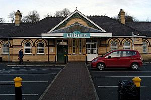
The Lisburn railway station opened on August 12, 1839. Express trains can reach Belfast's Great Victoria Street in about 10–15 minutes. The train also connects Lisburn directly to other towns like Newry, Portadown, and Bangor.
You can also catch trains to Dublin Connolly in the city of Dublin. All train services from Lisburn are run by Northern Ireland Railways. The city is also served by Hilden railway station.
Bus Services
Ulsterbus provides many bus services that connect Lisburn with Belfast city centre. These buses often travel along Belfast's Lisburn Road or through the Falls area. There are also buses to towns like Craigavon and Newry.
A network of local buses serves housing areas and other places within the city. There's also an hourly bus service to Belfast International Airport.
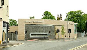
A new "Buscentre" opened in Lisburn on June 30, 2008. It is located at the corner of Smithfield Street and Hillsborough Road.
Road Connections
Lisburn is located on the main route between Belfast and Dublin. It is connected to Belfast by the M1 motorway. The A1 road to Newry and Dublin starts near Lisburn.
The city has an inner road system that helps traffic flow smoothly. This allows the city centre to have a one-way system and a pedestrian-only shopping area on Bow Street.
Waterways and Cycling
The Lagan Canal runs through Lisburn. This canal used to connect Belfast to Lough Neagh. It was an important way to transport goods before World War II. While it's no longer used for large boats, a small part of the canal in front of the Lisburn Council offices was restored in 2001.
Lisburn is also part of National Cycle Route 9, which connects the city with Belfast and Newry for cyclists.
Shopping in Lisburn
Lisburn offers several places to shop. Bow Street Mall, on Bow Street, has over 60 stores and many places to eat.
Just outside the city centre, you'll find Sprucefield Shopping Centre and Sprucefield Retail Park. These are two large retail parks with many different shops.
Lisburn's Climate
Lisburn has a maritime climate, which means it has cool summers and mild winters. The nearest weather station is in Hillsborough, about 3 miles (5 km) south of the city centre.
In Hillsborough, the warmest day of the year usually reaches about 24.3°C (75.7°F). The coldest night of the year typically drops to about -6.0°C (21.2°F). On average, there are about 37 nights with frost each year.
Lisburn usually gets just under 900 mm (35 inches) of rain each year. It rains on about 154 days of the year.
| Climate data for Hillsborough 116 m asl, 1971–2000, Extremes 1960–2005 (Weather Station 3.0 Miles SSW of Lisburn) | |||||||||||||
|---|---|---|---|---|---|---|---|---|---|---|---|---|---|
| Month | Jan | Feb | Mar | Apr | May | Jun | Jul | Aug | Sep | Oct | Nov | Dec | Year |
| Record high °C (°F) | 14.7 (58.5) |
15.8 (60.4) |
19.4 (66.9) |
22.8 (73.0) |
23.8 (74.8) |
28.1 (82.6) |
29.5 (85.1) |
28.4 (83.1) |
24.5 (76.1) |
21.1 (70.0) |
15.8 (60.4) |
14.5 (58.1) |
29.5 (85.1) |
| Mean daily maximum °C (°F) | 6.9 (44.4) |
7.1 (44.8) |
8.9 (48.0) |
10.9 (51.6) |
14.0 (57.2) |
16.4 (61.5) |
18.3 (64.9) |
18.0 (64.4) |
15.5 (59.9) |
12.4 (54.3) |
9.2 (48.6) |
7.6 (45.7) |
12.1 (53.8) |
| Mean daily minimum °C (°F) | 1.4 (34.5) |
1.6 (34.9) |
2.6 (36.7) |
3.5 (38.3) |
5.8 (42.4) |
8.6 (47.5) |
10.8 (51.4) |
10.6 (51.1) |
8.9 (48.0) |
6.5 (43.7) |
3.4 (38.1) |
2.2 (36.0) |
5.5 (41.9) |
| Record low °C (°F) | −12.2 (10.0) |
−7.8 (18.0) |
−10.0 (14.0) |
−4.9 (23.2) |
−3.3 (26.1) |
0.0 (32.0) |
2.5 (36.5) |
1.8 (35.2) |
−1.2 (29.8) |
−4.5 (23.9) |
−8.3 (17.1) |
−11.5 (11.3) |
−12.2 (10.0) |
| Average precipitation mm (inches) | 88.87 (3.50) |
61.65 (2.43) |
68.23 (2.69) |
58.03 (2.28) |
59.44 (2.34) |
62.45 (2.46) |
57.9 (2.28) |
77.89 (3.07) |
79.98 (3.15) |
91.85 (3.62) |
84.72 (3.34) |
91.03 (3.58) |
882.04 (34.74) |
Sports in Lisburn
In November 2012, Lisburn was named the European City of Sport for 2013. This was a special award given in Brussels.
Football Teams
- Lisburn Distillery is a football club that plays in the NIFL Championship. Their home ground is just outside the city.
- Ballymacash Rangers F.C. plays in the Mid-Ulster Football League.
- Lisburn Rangers F.C. plays in the Northern Amateur Football League.
- Downshire Young Men F.C. also plays in the Northern Amateur Football League.
Other Sports
- Lisburn Cricket Club
- Lisburn Racquets Club
- St. Patrick's GAA (Gaelic Athletic Association)
- Down Royal Racecourse is a horse racing track located near the city.
Famous People from Lisburn
Many notable people have connections to Lisburn.
Arts and Media
- Vivian Campbell (born 1962) – a singer-songwriter and musician.
- Sam Cree (1928–1980) – a playwright who wrote many plays.
- Richard Dormer (born 1969) – an actor, playwright, and screenwriter.
- Duke Special (born 1971) – a singer-songwriter.
- Kristian Nairn (born 1975) – a film actor and DJ, known for his role in Game of Thrones.
- Donna Traynor (born 1965) – a television journalist.
- Sir Richard Wallace (1818–1890) – a landlord, Member of Parliament, and art collector. The famous Wallace Collection in London is named after him.
Business
- Michael Deane (born 1961) – a famous chef and restaurateur.
- Alexander Turney Stewart (1803–1876) – an American retail entrepreneur.
Sport
- Damien Johnson – an international footballer for Northern Ireland.
- Mary Peters – a famous athlete.
- James Tennyson – a professional boxer.
- Alan McDonald – an international footballer for Northern Ireland.
See also
 In Spanish: Lisburn para niños
 | Misty Copeland |
 | Raven Wilkinson |
 | Debra Austin |
 | Aesha Ash |


