
Lagan Canal facts for kids
Quick facts for kids Lagan Navigation |
|
|---|---|

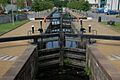
McLeave's Lock, which retains its original footbridge and lock keeper's cottage
|
|
| Specifications | |
| Length | 44 km (27 miles) |
| Locks | 27 |
| Status | part extant, part destroyed |
| History | |
| Original owner | Lagan Navigation Co |
| Principal engineer | Thomas Omer |
| Date of act | 1753 |
| Date of first use | 1763 |
| Date closed | 1958 |
| Geography | |
| Start point | Belfast |
| End point | Lough Neagh |
The Lagan Canal was a waterway built to connect Belfast to Lough Neagh, a large lake. It was about 44 kilometers (27 miles) long. The first part of the canal, which used the River Lagan, opened in 1763. It linked Belfast to Lisburn.
The second part, from Lisburn to Lough Neagh, was mostly a newly built canal. For a while, the Lagan Canal was one of the most successful canals in Ireland. However, it eventually couldn't compete with roads and railways. The canal closed in two stages, in 1954 and 1958.
A section of the canal between Sprucefield and Moira was destroyed in the 1960s. This happened when the M1 motorway was built. Today, different government groups look after most of the canal's remains. There is also a group working to reopen the canal.
Contents
Building the Lagan Canal
The idea of building a canal to connect the River Lagan to Lough Neagh came about in 1637. This was because the land between Moira and Lough Neagh was quite flat. Later, in 1741, a survey was done to plan the route.
In 1753, a special law was passed by the Irish Parliament to allow the canal to be built. An engineer named Acheson Johnston thought it would cost about £20,000. To pay for it, an extra tax was added to alcohol sold in the areas near the canal. Work on the canal started in 1756.
Early Construction and Challenges
The engineer in charge was Thomas Omer. Within the first year, about 6 miles (10 km) of the river were made ready for boats. This included digging new sections to straighten the river and building four locks. Locks are special gates that help boats move up or down between different water levels.
By 1763, the canal reached Lisburn. A boat carrying coal and timber officially opened this section. A small part was extended to Sprucefield by 1765, but then work stopped. About £40,000 had been spent. However, using the river had problems. It often flooded in winter. Also, linen factories along the river needed the water, and they didn't want the canal to control the river's flow.
In 1768, another engineer, Robert Whitworth, looked at the project. He said the river part was not good enough for boats. He suggested building a new canal section instead. In 1779, a new company called the 'Company of Undertakers of the Lagan Navigation' was formed. Important people, like the Marquess of Donegall, invested a lot of money in it.
Connecting to Lough Neagh
In 1782, Richard Owen took over the project. The company decided to build the canal on the south side of the Lagan river. This meant building a large structure called an aqueduct to carry the canal over the river. The aqueduct cost £3,000 and took almost three years to build.
Progress was slow, but the canal reached Aghalee in 1792. The final connection to Lough Neagh was finished in December 1793. The Marquess of Donegall officially opened the whole canal on January 1, 1794. He had paid most of the £62,000 cost himself. The highest part of the canal was 11 miles (18 km) long. It had 10 locks at Aghalee and four at Sprucefield.
How the Canal Worked
The Lagan Canal did not become as successful as people hoped at first. There were problems getting enough water for the highest part of the canal. This was because the linen factories still needed water from the Lagan River. Also, heavy rain sometimes damaged the canal banks below Lisburn.
Some people thought that using the river for the lower section was a big mistake. They believed the whole canal should have been built as a proper canal. The canal was meant to bring coal from east Tyrone to Belfast. But in reality, better quality coal was brought into Belfast by sea and then sent out along the canal.

In 1810, a group of business people from Belfast took over the canal. They wanted to build a new canal section from Belfast to avoid the tidal part of the river. Although new plans were made, they were never fully built. However, other improvements were made, like creating towpaths for horses to pull boats. This helped traffic on the canal increase.
In the 1820s and 1830s, roads started to compete with the canal for shorter journeys. People hoped that building the Ulster Canal, which would connect Lough Neagh to other waterways, would bring more long-distance traffic. In 1843, a new company, the Lagan Navigation Company, was formed to keep the canal in good condition.
The Lagan Canal successfully competed with the Ulster Railway and used its profits to make improvements. By 1859, it started paying dividends (a share of profits) to its owners. It was one of only two successful inland waterways in the north of Ireland. Traffic on the canal more than doubled by the 1870s.
The Lagan Navigation Company was concerned about the poor condition of the Ulster Canal. Boats from the Lagan Canal couldn't easily use the Ulster Canal because its locks were narrower. To fix this, the Lagan Canal built five special boats that could use both canals. In 1888, the Lagan Canal took over the Ulster Canal and another canal called the Coalisland Canal. Even though they spent a lot of money on improvements, these canals remained in poor shape and lost money. However, the Lagan Canal itself was well-maintained, and its traffic continued to grow.

The Canal's Decline
During the First World War, traffic on the canal dropped by half. After the war, the government returned the canal to private ownership. Money was spent on repairs, and traffic increased again. In the 1920s, a lot of coal and other goods were transported between Belfast and Lisburn.
Traffic above Lisburn was lower, but some coal still reached the Ulster Canal until it closed in 1931. Large amounts of sand and gravel were also carried from Lough Neagh to Belfast for building projects. However, just before the Second World War, commercial canal traffic collapsed. Canals were seen as too slow compared to roads and railways.
The company ran out of money and considered closing the canal. But a law from 1843 said the company would stop existing if the canals became unusable. To avoid problems, the government paid the company to cover its losses and help with repairs. These payments totaled £130,000 between 1938 and 1952.
Since 1947, there had been no traffic above Lisburn. So, in 1954, the government announced that the canals would close. A new law was passed, and the Lagan Canal above Lisburn closed. The section below Lisburn stayed open for four more years, closing on July 1, 1958. In 1965, about 7.7 miles (12.4 km) of the central part of the canal were destroyed when the M1 motorway was built along its route.
Bringing the Canal Back to Life
There are plans to restore the Lagan Canal. The goal is to create a way for boats to travel between Belfast and Lough Neagh again. A group called the Lagan Canal Restoration Trust was formed in 2008. It included representatives from local councils and other important organizations. In 2016, the Trust changed its name to the Lagan Navigation Trust.

A study was done to see if restoring the canal was possible. It found that even though parts of the canal were destroyed by the M1 motorway, there were no impossible problems. The study said the canal could become "one of the most significant recreational waterways" in the area.
A small part of the canal near Lisburn Civic Centre, including Lock 12, has already been restored for boats. Also, three main sections of the towpath are now open to the public. Many of the canal's locks and other structures are protected as "scheduled monuments."
A project to build a new lock, weir, and footbridge at Stranmillis Gateway was first suggested in 2005. This is where the original first lock was located. The plan grew to include restoring the first 10 kilometers (6 miles) of the canal. Even though a trust offered £1 million to start the project, it didn't make much progress at first. Lock 3 at Newforge has been restored, along with the lock keeper's house.
A 1.5-kilometer (1-mile) stretch of the towpath at Aghagallon has also been reopened. This is the first part of the canal between Aghalee and Lough Neagh that is now open to the public, as this section used to be privately owned.
_at_Moira_-_geograph.org.uk_-_360218.jpg)
The project to build a new lock at Stranmillis and restore Lock 2 started again in late 2017. The new lock will help boats navigate the river and prevent erosion. The cost has risen to £4 million, with funding from Belfast City Council and other groups. Lock 2 is located in the Lagan Valley Regional Park.
Images for kids
-
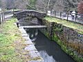
McLeave's Lock, which retains its original footbridge and lock keeper's cottage
-
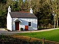
Kilpatrick Families lock-keeper's cottage near Shaw's Bridge, built 1827–34
-
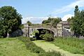
The Ulster Railway crossing the Lagan Canal near Moira.
-
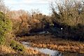
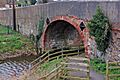
An overgrown section of the Lagan Canal near Dunmurry.
-
The restored Lock 12 at Lisburn.
-
Albert Bridge, carrying Station Road at Moira.
_-_geograph.org.uk_-_640122.jpg)
