
Antrim County, Michigan facts for kids
Quick facts for kids
Antrim County
|
|
|---|---|

Antrim County Courthouse
|
|

Location within the U.S. state of Michigan
|
|
 Michigan's location within the U.S. |
|
| Country | |
| State | |
| Founded | 1840 (authorized) 1863 (organized) |
| Named for | County Antrim |
| Seat | Bellaire |
| Largest village | Elk Rapids |
| Area | |
| • Total | 602 sq mi (1,560 km2) |
| • Land | 476 sq mi (1,230 km2) |
| • Water | 126 sq mi (330 km2) 21%% |
| Population
(2020)
|
|
| • Total | 23,431 |
| • Density | 50/sq mi (20/km2) |
| Time zone | UTC−5 (Eastern) |
| • Summer (DST) | UTC−4 (EDT) |
| Congressional district | 1st |
| Website | https://www.antrimcounty.org/ |
Antrim County (pronounced AN-trəm) is a county in the state of Michigan. In 2020, about 23,431 people lived there. The main town, or county seat, is Bellaire. The county got its name from County Antrim in Northern Ireland.
Antrim County is home to Torch Lake. This is Michigan's deepest and second-largest inland lake. Torch Lake is famous for its clear, blue water. It is part of the Chain of Lakes Watershed. Most of this watershed is within Antrim County. The county's western side touches Grand Traverse Bay, which is part of Lake Michigan.
Contents
Exploring Antrim County's Past
Antrim County has a rich history. It was first created in 1840.
How Antrim County Got Its Name
The area was first called Meegisee County in 1840. This name came from a Chippewa chief. He signed important treaties in 1821 and 1826. The name "Meegisee" also comes from the Ojibwe word migizi. This word means bald eagle.
In 1843, the county's name changed to Antrim County. This was one of five Michigan counties given Irish names. It was done to honor the growing number of Irish settlers in Michigan.
Early County Government
For a while, Antrim County was connected to Grand Traverse County for government purposes. But in 1863, Antrim County started its own separate government.
The county seat was first in Elk Rapids. However, it moved to Bellaire in 1904. This move happened after 25 years of legal arguments.
Important Moments in History
YMCA Camp Hayo-Went-Ha opened in 1904. It is on the shore of Torch Lake. This camp is the oldest American summer camp still on its original site.
Antrim County was in the news during the 2020 presidential election. An early vote count showed a surprising result. The County Clerk quickly found it was a human mistake. She fixed the count before sending it to the state. This error and a related lawsuit were mentioned in some election discussions.
Geography and Natural Beauty
Antrim County covers about 602 square miles. Of this, 476 square miles are land. The remaining 126 square miles (21%) are water.
Grand Traverse Bay borders the county to the west. This bay is part of Lake Michigan. Many lakes in the Chain of Lakes are in Antrim County. This includes the famous Torch Lake.
Major Lakes in Antrim County
Antrim County is known for its many beautiful lakes.
- Lake Bellaire
- Clam Lake
- Elk Lake
- Ellsworth Lake
- Intermediate Lake
- Little Torch Lake
- Lake Skegemog
- Torch Lake
Important Rivers in Antrim County
Several rivers flow through Antrim County.
Communities and Towns
Antrim County has several villages and smaller communities.
Villages in Antrim County
- Bellaire (the county seat)
- Central Lake
- Elk Rapids
- Ellsworth
- Mancelona
Other Communities
There are also smaller communities and places called census-designated places (CDPs).
Indian Reservations
The Grand Traverse Indian Reservation has small areas within Antrim County. These are located in Helena Township and Milton Township.
Education in Antrim County
Students in Antrim County are served by the Northwest Educational Services. This organization helps students in several counties. It offers special education, early education, and programs for English learners. It also provides technical career training.
Public School Districts
Antrim County has several public school districts:
- Alba Public Schools
- Bellaire Public Schools
- Central Lake Public Schools
- Elk Rapids Schools
- Ellsworth Community Schools
- Mancelona Public Schools
Private Schools
There is one private school in Antrim County. It is the Ebenezer Christian School.
Getting Around Antrim County
Antrim County has several important highways that help people travel.
State Highways
 US 31: This highway runs north-south along Grand Traverse Bay. It goes through towns like Elk Rapids and Eastport.
 US 131: This highway runs mostly southwest-northeast in the eastern part of the county. It passes through Mancelona and Alba.
 M-32: This east-west highway is in northeastern Antrim County. It goes through Elmira.
 M-66: This north-south highway goes through central Antrim County. It connects with US 131 in Mancelona.
 M-88: This highway is entirely within Antrim County. It connects Bellaire and Central Lake to US 31 and US 131/M-66.
County Highways
Antrim County also has county-designated highways. These roads help connect smaller communities.
 C-38
C-38 C-42
C-42 C-48
C-48 C-65
C-65 C-73
C-73
Air Travel
The Antrim County Airport is a public airport. It is northeast of Bellaire. It is used for general aviation, which means smaller planes. It does not have airline service.
Images for kids
-
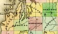
A map from 1842 showing Antrim County when it was called Meegisee County.
-
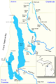
Map of the Chain of Lakes, which are mostly in Antrim County.
-
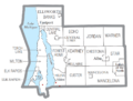
A map showing local town boundaries in Antrim County.
-
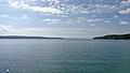
A beautiful view of Torch Lake.
-
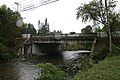
The M-88 bridge crossing the Intermediate River in Bellaire.
-
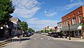
Downtown Elk Rapids.


.jpg)

.jpg)
See also
 In Spanish: Condado de Antrim (Míchigan) para niños
