
Grand Traverse Bay facts for kids
Quick facts for kids Grand Traverse Bay |
|
|---|---|

East Arm of Grand Traverse Bay looking west from Elk Rapids toward Old Mission Peninsula
|
|

Grand Traverse
Location in Michigan
|
|
| Location | Grand Traverse County, Michigan Antrim County, Michigan Leelanau County, Michigan |
| Coordinates | 45°04′N 85°29′W / 45.06°N 85.48°W |
| Type | Bay |
| Part of | St. Lawrence Watershed |
| Primary inflows | Boardman River, Elk River |
| Primary outflows | Lake Michigan |
| Surface elevation | 581 feet (177 m) |
| Islands | Power Island |
Grand Traverse Bay is a large, deep bay that is part of Lake Michigan. It's located in the northwestern part of the Lower Peninsula of Michigan. The bay is about 32 miles (51 km) long and 10 miles (16 km) wide. In some places, it can be as deep as 620 feet (189 m)!
The bay is split into two main sections, called the East Arm and the West Arm. These two arms are separated by a piece of land called the Old Mission Peninsula. The entire bay is also part of a special protected area called the Grand Traverse Bay Bottomland Preserve. It's important not to confuse this bay with another Grand Traverse Bay, which is located in Lake Superior.
Contents
Exploring Grand Traverse Bay
Traverse City is a city found at the very southern end of the bay. Here, the Boardman River flows into the western arm of the bay. The area around the bay is famous for its cherry orchards. Because of this, Traverse City is known as the Cherry Capital of the World! Many companies in the region make tasty cherry products using the tart cherries grown here.
The most interesting thing about the bay's shape is how the Old Mission Peninsula divides it into two arms. Grand Traverse Bay also has several smaller bays within it. These include Northport Bay, Suttons Bay, Omena Bay, Bowers Harbor, and Old Mission Bay.
Northport Bay is in the northwest corner of Grand Traverse Bay. It's about 10 miles (16 km) long and 4 miles (6.4 km) wide. This bay is mostly open to the east, with the Leelanau Peninsula on its western side. There are some shallow areas in Northport Bay that are marked with buoys to help boats.

Towns and Villages
Many towns and villages are located around the shores of Grand Traverse Bay. Some of these communities include:
- Northport
- Omena
- Peshawbestown
- Suttons Bay
- Greilickville
- Traverse City
- Bowers Harbor
- Neahtawanta
- Old Mission Point
- Old Mission
- Archie
- Acme
- Yuba
- Elk Rapids
- Antrim City
- Norwood

Islands in the Bay
Grand Traverse Bay has a few islands. The largest one is Power Island.
- Bellow Island (also known as Gull Island)
- Bassett Island
- Power Island (the biggest island in the bay)

How the Bay Got Its Name
Grand Traverse Bay got its name from French explorers and traders called voyageurs in the 1700s. They used to make la grande traverse, which means "the long crossing," across the mouth of the bay.
At first, the area was controlled by the French, then by Great Britain. After 1776, it became part of the United States. In 1839, the first lasting settlement was started on the Old Mission Peninsula by Rev. Peter Doughtery. This settlement was first called "Grand Traverse," but its name was later changed to Old Mission.


Fun Facts and Discoveries
Besides cherries, the countryside around Grand Traverse Bay also grows grapes. This area is an important center for the Michigan wine industry. With its sparkling blue water and golden sand beaches, the Grand Traverse Bay region is a very popular place for vacations.
In 2007, a scientist named Mark Holley, who studies old things underwater, said that they might have found a very old rock with a carving on it in Grand Traverse Bay. The rock is about 3.5 to 4 feet (1.1 to 1.2 m) high and 5 feet (1.5 m) long. The markings on the granite rock look like a mastodon (an ancient elephant-like animal) with a spear in its side. More proof is needed to confirm if these markings are truly an ancient petroglyph, which is a carving made in rock.
-
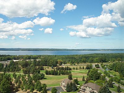
The East Arm of Grand Traverse Bay from the east, with the Old Mission Peninsula in the background.
-
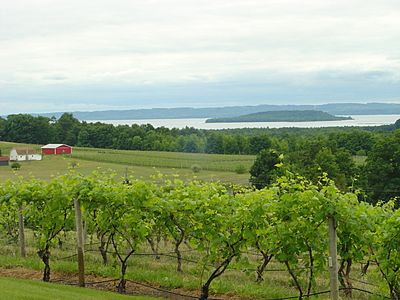
The West Arm of Grand Traverse Bay, seen from Chateau Chantal on the Old Mission Peninsula.


Shipwrecks in the Bay
Over the years, several ships have sunk in Grand Traverse Bay. Some of these shipwrecks include:

- A.J. Rogers
- Metropolis
- Shale Scow
- Yuba Wreck
- Tramp
- Elmwood
- Nyord
- Barge
