
Elk Rapids, Michigan facts for kids
Quick facts for kids
Elk Rapids, Michigan
|
|
|---|---|
|
Village
|
|
| Village of Elk Rapids | |
.jpg)
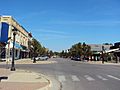
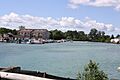
Downtown Elk Rapids along River Street
|
|
,_MI_location.png)
Location within Antrim County
|
|

Elk Rapids, Michigan
Location in Michigan
|
|
| Country | |
| State | |
| County | Antrim |
| Township | Elk Rapids |
| Platted | 1852 |
| Incorporated | 1900 |
| Government | |
| • Type | Village council |
| Area | |
| • Total | 2.01 sq mi (5.20 km2) |
| • Land | 1.65 sq mi (4.27 km2) |
| • Water | 0.36 sq mi (0.93 km2) |
| Elevation | 597 ft (182 m) |
| Population
(2020)
|
|
| • Total | 1,529 |
| • Density | 926.67/sq mi (357.68/km2) |
| Time zone | UTC-5 (Eastern (EST)) |
| • Summer (DST) | UTC-4 (EDT) |
| ZIP code(s) |
49629
|
| Area code(s) | 231 |
| FIPS code | 26-25320 |
| GNIS feature ID | 0625459 |
Elk Rapids is a charming small town, known as a village, located in the beautiful state of Michigan in the United States. It's the biggest village in Antrim County, with about 1,529 people living there as of the 2020 census.
Elk Rapids is found in the southwest part of Antrim County. It sits right on the edge of Grand Traverse Bay, which is a part of the huge Lake Michigan. The village is about 12 miles (19 km) southwest of Bellaire, which is the main town of the county. It's also about 13 miles (21 km) northeast of Traverse City, the largest city in Northern Michigan.
Contents
History of Elk Rapids
The first person to settle in the Elk Rapids area was Abram S. Wadsworth from Connecticut. He planned out the town in 1852 and first called it Stevens. A post office opened there in 1854.
In 1858, Wadsworth changed the town's name to Elk Rapids. He chose this name after finding some elk antlers near the mouth of what is now called the Elk River.
In 1863, Antrim County was officially created, and Elk Rapids became its main town, or county seat. However, the county seat was later moved to Bellaire in 1879 because Bellaire was more in the center of the county.
In 1892, Elk Rapids became a stop on a train line called the Chicago and West Michigan Railway. The town officially became an incorporated village in the year 1900.
Geography and Waterways
Elk Rapids covers a total area of about 2.01 square miles (5.20 km²). Most of this, about 1.65 square miles (4.27 km²), is land, and 0.36 square miles (0.93 km²) is water.
The village is located on a narrow strip of land, almost like an isthmus. To the east of the village is Elk Lake. This is the 15th largest inland lake in Michigan. It's also part of a group of connected lakes and rivers called the Elk River Chain of Lakes Watershed.
To the west of Elk Rapids is the East Arm of Grand Traverse Bay, which is a large bay of Lake Michigan. The Elk River flows right through the middle of the village. It starts from Elk Lake and flows northwest into Grand Traverse Bay. Elk Rapids is also about 2 miles (3.2 km) north of the Grand Traverse County line.
Climate and Weather
Elk Rapids has a humid continental climate. This means it has big differences in temperature throughout the year. Summers are warm to hot and often humid. Winters are cold, and sometimes very cold.
| Climate data for Elk Rapids, Michigan | |||||||||||||
|---|---|---|---|---|---|---|---|---|---|---|---|---|---|
| Month | Jan | Feb | Mar | Apr | May | Jun | Jul | Aug | Sep | Oct | Nov | Dec | Year |
| Mean daily maximum °C (°F) | 29 (−2) |
31 (−1) |
40 (4) |
53 (12) |
65 (18) |
75 (24) |
80 (27) |
78 (26) |
70 (21) |
57 (14) |
46 (8) |
34 (1) |
55 (13) |
| Mean daily minimum °C (°F) | 17 (−8) |
16 (−9) |
22 (−6) |
32 (0) |
41 (5) |
52 (11) |
57 (14) |
57 (14) |
50 (10) |
40 (4) |
32 (0) |
22 (−6) |
37 (3) |
| Average precipitation mm (inches) | 1.4 (36) |
0.9 (23) |
1.5 (38) |
2.1 (53) |
2.7 (69) |
3.2 (81) |
2.8 (71) |
3.5 (89) |
3.5 (89) |
3.4 (86) |
1.9 (48) |
1.6 (41) |
28.4 (720) |
| Source: Weatherbase | |||||||||||||
Population and People
| Historical population | |||
|---|---|---|---|
| Census | Pop. | %± | |
| 1880 | 620 | — | |
| 1910 | 1,673 | — | |
| 1920 | 684 | −59.1% | |
| 1930 | 615 | −10.1% | |
| 1940 | 690 | 12.2% | |
| 1950 | 889 | 28.8% | |
| 1960 | 1,015 | 14.2% | |
| 1970 | 1,249 | 23.1% | |
| 1980 | 1,504 | 20.4% | |
| 1990 | 1,626 | 8.1% | |
| 2000 | 1,700 | 4.6% | |
| 2010 | 1,642 | −3.4% | |
| 2020 | 1,529 | −6.9% | |
| U.S. Decennial Census | |||
2010 Census Information
In 2010, there were 1,642 people living in Elk Rapids. These people lived in 791 households, and 478 of those were families. The village had about 995 people per square mile (384 people per km²).
Most of the people in Elk Rapids were White (96.6%). A small number were African American, Native American, or Asian. About 1.3% of the population was Hispanic or Latino.
About 21% of households had children under 18 living with them. The average age of people in the village was 52.4 years old. About 18.6% of residents were under 18, and 28.7% were 65 or older. Slightly more than half of the residents (53.5%) were female.
Education in Elk Rapids
Public schools in Elk Rapids are part of the Elk Rapids Schools district. This district teaches students from kindergarten all the way through 12th grade.
Within the village, there are three schools:
- Lakeland Elementary School
- Cherryland Middle School
- Elk Rapids High School
The district also has Mill Creek Elementary School, which is in the nearby community of Williamsburg.
Major Roads
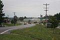
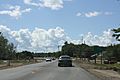
 US 31 is a main highway that runs north and south through Elk Rapids. It passes just east of the downtown area. US 31 follows the shore of Lake Michigan. You can use this highway to reach nearby cities like Charlevoix to the north and Traverse City to the south.
Images for kids
-
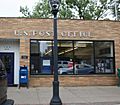
Post office
-
Looking north at the city sign
-
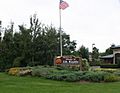
City welcome sign
-
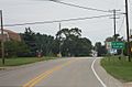
Looking north on US 31
-
Sign on US 31
-
Downtown Elk Rapids on River Street
-
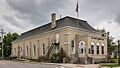
Elk Rapids Township Hall
-
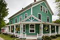
Hughes House
-
Elk River from US 31
-
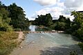
The Elk River
-
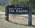
Welcome sign along US 31


.jpg)


See also
 In Spanish: Elk Rapids (Míchigan) para niños
