
Lower Peninsula of Michigan facts for kids
Quick facts for kids
Lower Peninsula of Michigan
|
|
|---|---|

|
|
| Nickname(s):
The Mitten
|
|

Regions and major cities of the Lower Peninsula
|
|
| Country | United States |
| State | Michigan |
| Area | |
| • Total | 40,162 sq mi (104,020 km2) |
| Population
(2015 est.)
|
|
| • Total | 9,584,261 |
| • Density | 238.6400/sq mi (92.1394/km2) |
The Lower Peninsula of Michigan is a large piece of land that makes up most of the U.S. state of Michigan. It is the southern part of the state and is mostly flat. The other main part of Michigan is the Upper Peninsula, which is separated by the Straits of Mackinac.
This peninsula is surrounded by water on almost all sides. Only its southern border touches land, where it meets the states of Indiana and Ohio. Even though the Upper Peninsula is often called "the U.P.", people don't usually call the Lower Peninsula "the L.P."
Contents
The Mitten: A Unique Shape
The Lower Peninsula has a very special shape that looks like a hand. Because of this, it is often called The Mitten. The eastern part of the "mitten" is known as "The Thumb".
This unique shape has led to fun stories about how the land was formed. One story says it's a handprint from Paul Bunyan, a giant lumberjack from American folklore. When people who live here are asked where they are from, they might hold up their right hand and point to a spot on their palm to show their home.
The Lower Peninsula is sometimes split into two main parts. The Northern Lower Peninsula has fewer people and lots of forests. The Southern Lower Peninsula has more cities and farms.
Geography of Lower Michigan
The Lower Peninsula is bordered by Lake Michigan to the west and Lake Huron to the northeast. These two large lakes connect at the Straits of Mackinac. To the southeast, a series of waterways like the St. Clair River and Lake Erie separate it from Ontario, Canada.
Its southern border touches Indiana and Ohio. This border is a bit unusual because of an old disagreement about land. The Lower Peninsula is part of a larger flat area called the Great Lakes Plain.
Size and Landscape
From north to south, the Lower Peninsula is about 277 miles (446 km) long. From east to west, it is about 195 miles (314 km) wide. It holds almost two-thirds of all the land in Michigan.
The land here is generally flat. You might see some small, rounded hills, especially in the northern parts. The highest point in the Lower Peninsula is likely Briar Hill, which is about 1,705 feet (520 m) tall. The lowest point is at the shore of Lake Erie, at 571 feet (174 m).
Lakes and Rivers
The western coast has many sandy beaches and tall sand dunes. These were formed by Lake Michigan and the strong winds. Saginaw Bay is a large, shallow bay surrounded by a similar shallow area where water drains into it.
Many big rivers flow into the Great Lakes. Some of these include the Kalamazoo, Grand, Muskegon, and Manistee rivers, which flow into Lake Michigan. The Au Sable and Tittabawassee rivers flow into Lake Huron. Because of all these rivers and lakes, you are never more than 6 miles (10 km) from a body of water. You are also at most 85 miles (137 km) from one of the Great Lakes.
Plants and Animals
The Lower Peninsula is home to many different plants and animals. Groups like the American Bird Conservancy and the National Audubon Society have named several places here as important areas for birds from all over the world. These places are called Important Bird Areas.
Geology: The Michigan Basin
The Lower Peninsula sits on top of a special geological feature called the Michigan Basin. Imagine a giant, nearly circular bowl underground. The layers of rock in this "bowl" all gently slope down towards the center of the peninsula.
This basin is deepest in Gladwin County, where the oldest rocks are about 16,000 feet (4,900 m) deep. Around the edges, like near Mackinaw City, Michigan, these old rocks are closer to the surface, about 4,000 feet (1,200 m) down.
Climate
The weather in the Lower Peninsula changes a lot throughout the year. Most months, temperatures range from a low of 14 degrees Fahrenheit (about -10 degrees Celsius) to a high of 84 degrees Fahrenheit (about 29 degrees Celsius).
Regions of the Lower Peninsula

The Lower Peninsula of Michigan can be divided into four main areas. These areas are different based on their geology, soil, plants, how many cities or farms they have, and their cultures. These four main regions can also be broken down into smaller parts.
- Northern Michigan
- Central/Mid-Michigan
- The Thumb
- Tri-Cities
- Southern Michigan
- West Michigan
- Southern Michigan
- Michiana
- Southeast Michigan
Getting Around: Transportation
The Lower Peninsula has many ways to travel, including major airports and highways.
Major Airports
- Alpena County Regional Airport (APN) in Alpena
- Bishop International Airport (FNT) in Flint
- Capital Region International Airport (LAN) in Lansing
- Cherry Capital Airport (TVC) in Traverse City
- Detroit Metropolitan Wayne County Airport (DTW) in Romulus
- Gerald R. Ford International Airport (GRR) in Grand Rapids
- Kalamazoo/Battle Creek International Airport (AZO) in Kalamazoo
- MBS International Airport (MBS) in Saginaw
- Pellston Regional Airport (PLN) in Pellston
Highways
Many important highways cross the Lower Peninsula.
Interstate Highways
U.S. Highways
 US 10
US 10 US 12
US 12 US 23
US 23 US 24
US 24 US 31
US 31 US 127
 US 131
 US 223
You can also travel along the Great Lakes Circle Tour, which is a special route that connects all of the Great Lakes.
Images for kids
-
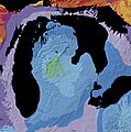
Geologic map of the Michigan Basin

See also
 In Spanish: Península inferior de Míchigan para niños
