Au Sable River (Michigan) facts for kids
Quick facts for kids Au Sable River |
|
|---|---|
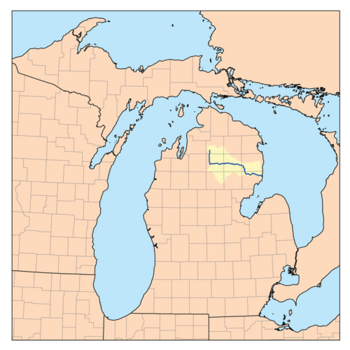
Map of the Au Sable River
|
|
| Country | United States |
| Physical characteristics | |
| Main source | Frederic Township, Crawford County, Michigan |
| River mouth | Lake Huron at Au Sable, Michigan 581 ft (177 m) |
| Length | 138 miles (222 km) |
| Type: | Scenic |
| Designated: | October 4, 1984 |
The Au Sable River is a cool river in Michigan, United States. It flows for about 138 miles (222 km) through the northern part of Michigan's Lower Peninsula. You can find it passing through towns like Grayling and Mio. Finally, it empties into Lake Huron near Oscoda.
This river is super famous for its brown trout fishing. Many people think it's one of the best places to catch brown trout east of the Rockies. The Michigan Department of Natural Resources even calls it a "blue ribbon" trout stream. The name "Au Sable" comes from the French words Rivière au sable, which means "Sand River." Back in 1795, a map called it the Beauais River.
Contents
Exploring the Au Sable River
The Au Sable River collects water from a huge area, about 1,932 square miles (5,000 km²). This is called its drainage basin. The river drops about 650 feet (198 meters) from where it starts.
Where the River Begins
The main part of the Au Sable River starts in Frederic Township. This is in Crawford County. It forms when two smaller streams, Kolke Creek and Bradford Creek, join together. These creeks both begin in Otsego County.
The river first flows south, then turns east. It goes through Grayling. Here, another important branch, the East Branch Au Sable River, joins it. The East Branch also starts in Crawford County.
River Branches and Flow
As the Au Sable continues east, it's joined by the South Branch Au Sable River. This branch starts from Lake St. Helen in Roscommon County. It flows northwest, then northeast to meet the main river.
A little further east, the North Branch Au Sable River joins the main stream. This happens near the border of Oscoda County. The North Branch begins in Otsego County, near Lake Otsego.
The Au Sable then flows mostly east through Oscoda County. After that, it turns south and east through Alcona County and Iosco County. Water from parts of Montmorency County and Ogemaw County also drains into the river.
Nature and Scenery
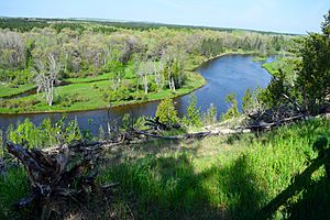
A big part of the Au Sable River flows through or next to the Huron-Manistee National Forest. About 23 miles (37 km) of the river is special. It's called a National Wild and Scenic River. This special status was given on October 4, 1984.
The river's area is home to amazing wildlife. You might spot bald eagles flying overhead. It's also a key place for the endangered Kirtland's warbler, a small bird. A good portion of the land around the river is protected as National Forest or state forest.
Fun on the River
The Au Sable River is a popular spot for fishing. It's known as a great place to catch trout. Long ago, the river had grayling fish. Then, in the 1880s, brook trout were released here. By 1908, the grayling were gone, but they were brought back in 1987. Today, brown trout are the main fish caught.
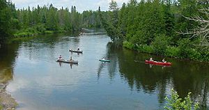
Many places along the river rent canoes. You can take canoe trips that last from a few hours to a whole week!
The Lumberman's Monument is a cool place to visit on the river. It honors the lumberjacks who worked in the area long ago. Lumbering, which is cutting down trees for wood, was a big industry here from the 1860s to the 1910s.
Au Sable River Canoe Marathon
The Au Sable River is also famous for a yearly canoe race. It's called the Au Sable River Canoe Marathon. This is a super tough, 120-mile (193 km) race for professional and amateur canoeists. It starts at 9:00 p.m. and racers paddle through the night! The fastest teams finish in about 14 to 21 hours. This exciting race first happened in 1947.
Scenic Drives
If you want to see beautiful views, check out River Road. It runs right next to the Au Sable River. This road is a special National Scenic Byway.
River Power
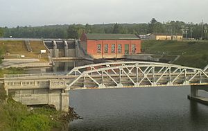
There are six hydro-electric power plants along the Au Sable River. These plants use the river's flow to create electricity. They were built between 1911 and 1924. The Au Sable also has about 350 miles (563 km) of smaller streams that flow into it, like the Pine River.
Towns Along the River
- Arbutus Beach, Michigan
- Au Sable, Michigan
- Curtisville, Michigan
- Glennie, Michigan
- Grayling, Michigan
- Lewiston, Michigan
- Lovells, Michigan
- Mio, Michigan
- Oscoda, Michigan
- Roscommon, Michigan
River Dams
These dams are owned by the power company Consumers Energy. They are listed from upriver (where the river starts) to downriver (where it ends):
- Mio Dam
- Alcona Dam
- Loud Dam
- Five Channels Dam
- Cooke Dam
- Foote Dam
Historical Markers
You can find five special historical markers along the river:
- Cooke Hydroelectric Plant
- Five Channels Dam Workers Camp
- The Louis Chevalier Claim
- Mio Hydroelectric Plant
- Chief Shoppenagon
River Valley Attractions and Events
- The Michigan AuSable Valley Railroad is in Fairview. It's a miniature train that offers fun rides through the beautiful Northern Michigan landscape. You'll see parts of the Huron National Forest and the Comins Creek Valley.
- The Au Sable River Canoe Marathon starts in Grayling and finishes in Oscoda. This 120-mile (193 km) race is part of canoe racing's "Triple Crown." It's always held on the last full weekend in July.
- The First Dam Canoe Race (MCRA - Canoe Race) is another yearly event for canoe enthusiasts.
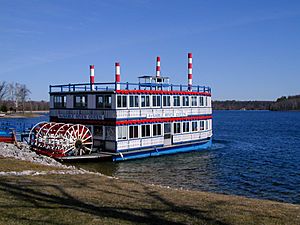
- About 6 miles (10 km) west of Oscoda, you can ride the Au Sable River Queen. This paddle boat offers fun trips on the river.
- This area is very important for bird watchers. It's a great place to see the Kirtland's warbler.
- The Lumberman's Monument is right next to the river. It's a cool spot to learn about the area's history.
- River Road, which runs along the river, is a special National Scenic Byway. It's 23 miles (37 km) long and leads into Oscoda.
- Canoer's Memorial
- Iargo Springs
 | Emma Amos |
 | Edward Mitchell Bannister |
 | Larry D. Alexander |
 | Ernie Barnes |


