Oscoda County, Michigan facts for kids
Quick facts for kids
Oscoda County
|
|
|---|---|

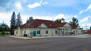
The rebuilt Oscoda County Courthouse in Mio
|
|

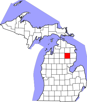
Location within the U.S. state of Michigan
|
|
 Michigan's location within the U.S. |
|
| Country | |
| State | |
| Founded | April 1, 1840 (created) 1881 (organized) |
| Seat | Mio |
| Largest community | Mio |
| Area | |
| • Total | 572 sq mi (1,480 km2) |
| • Land | 566 sq mi (1,470 km2) |
| • Water | 5.9 sq mi (15 km2) 1.0%% |
| Population
(2020)
|
|
| • Total | 8,219 |
| • Density | 15/sq mi (6/km2) |
| Time zone | UTC−5 (Eastern) |
| • Summer (DST) | UTC−4 (EDT) |
| Congressional district | 1st |
Oscoda County is a place in the state of Michigan, USA. It is one of the many counties that make up the state. In 2020, about 8,219 people lived here. This makes it one of the least populated counties in Michigan. The main town, or county seat, is Mio. Mio is a small community located near the middle of the county.
Contents
History of Oscoda County
The county was officially created on April 1, 1840. However, it took many years for its government to be fully set up. This happened much later, in 1881.
The name "Oscoda" was created by a man named Henry Rowe Schoolcraft. He was a US Indian agent and also a geographer. He often named new counties and towns. The name is thought to combine two words from the Ojibwa language. These words are "ossin" (meaning stone) and "muskoda" (meaning prairie). So, Oscoda might mean 'pebbly prairie'.
Geography of Oscoda County
Oscoda County covers about 572 square miles. Most of this area, about 566 square miles, is land. The rest, about 5.9 square miles, is water. This county is located in the northern part of Michigan.
Special Geographic Features
- The town of Mio is located in the beautiful Au Sable River Valley.
- The county is surrounded by large natural areas. These include the Huron National Forest and the Rifle River State Recreation Area.
- Oscoda County is also part of the Au Sable State Forest. This forest is managed for fire safety and includes several counties.
- A large part of the area is a special type of land called the "Grayling outwash plain." This unique area was formed by glaciers long ago.
- You can get a great view of the area from the Oscoda County Park.
Long ago, huge sheets of ice called glaciers moved across this land. They shaped the ground and created a special natural environment. The Grayling outwash plain has sandy ridges, areas with jack pine trees, and forests with white pine and red pine. The glaciers also formed many large lakes.
Main Roads in Oscoda County
- M-33 runs north and south through the middle of the county. It goes through towns like Fairview and Mio.
- M-72 enters the county from the west. It runs east and meets M-33 in Mio. This road passes through Luzerne. M-72 is one of only three roads that go all the way across the Lower Peninsula.
- F-32 goes east from Mio into Alcona County. It passes through McKinley.
Neighboring Counties
Oscoda County shares its borders with these other counties:
- Montmorency County to the north
- Alpena County to the northeast
- Alcona County to the east
- Iosco County to the southeast
- Ogemaw County to the south
- Roscommon County to the southwest
- Crawford County to the west
- Otsego County to the northwest
Protected Natural Areas
- A part of the Huron National Forest is located within Oscoda County.
Communities in Oscoda County
Oscoda County is unique because it does not have any officially incorporated cities or villages. All its communities are considered townships or unincorporated places.
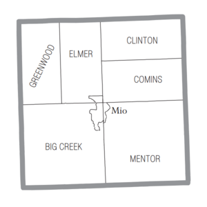
Civil Townships
- Big Creek Township
- Clinton Township
- Comins Township
- Elmer Township
- Greenwood Township
- Mentor Township
Main Community (Census-designated place)
- Mio is the county seat, which means it's where the county government is located.
Other Small Communities
Population of Oscoda County
| Historical population | |||
|---|---|---|---|
| Census | Pop. | %± | |
| 1870 | 70 | — | |
| 1880 | 467 | 567.1% | |
| 1890 | 1,904 | 307.7% | |
| 1900 | 1,468 | −22.9% | |
| 1910 | 2,027 | 38.1% | |
| 1920 | 1,783 | −12.0% | |
| 1930 | 1,728 | −3.1% | |
| 1940 | 2,543 | 47.2% | |
| 1950 | 3,134 | 23.2% | |
| 1960 | 3,447 | 10.0% | |
| 1970 | 4,726 | 37.1% | |
| 1980 | 6,858 | 45.1% | |
| 1990 | 7,842 | 14.3% | |
| 2000 | 9,418 | 20.1% | |
| 2010 | 8,640 | −8.3% | |
| 2020 | 8,219 | −4.9% | |
| 2023 (est.) | 8,545 | −1.1% | |
| US Decennial Census 1790-1960 1900-1990 1990-2000 2010-2018 |
|||
In 2000, about 9,418 people lived in Oscoda County. By 2020, the population had changed to 8,219 residents. The county has a lower population density compared to many other areas. This means there are fewer people living per square mile.
Fun Things to Do in Oscoda County
The Au Sable River near Mio is a great place for outdoor activities. You can go fishing, canoeing, kayaking, or even tubing down the river. There are special areas to launch boats and public facilities north of Mio, near the M-33 highway. Another launch area is at the Mio Dam Pond.
Oscoda County also has many trails for different activities. You can find trails for snowmobiles, ATVs (all-terrain vehicles), hiking, and cross-country skiing. These trails are located around Luzerne, McKinley, and Mio. There's a special "scramble area" for off-road vehicles called Bull Gap in the Huron National Forest. The Loud Creek Trail offers seven different routes for cross-country skiing, with varying difficulty levels. The total length of this trail is 10 kilometers.
In Fairview, you can find a ranch for horseback riding and a golf course. Karefree Ranch Boarding Stables offers guided horseback rides through the beautiful Huron National Forest. If you like golf, the Fairview Hills Golf Club is a 9-hole course located on M-33.
See also
 In Spanish: Condado de Oscoda para niños
 | Anna J. Cooper |
 | Mary McLeod Bethune |
 | Lillie Mae Bradford |


