Alcona County, Michigan facts for kids
Quick facts for kids
Alcona County
|
||
|---|---|---|
|
||
|
||
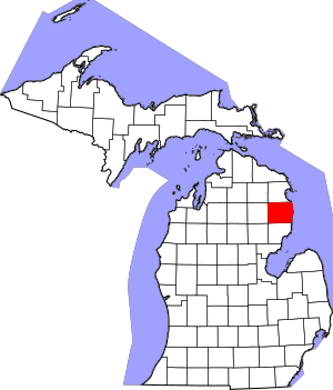
Location within the U.S. state of Michigan
|
||
 Michigan's location within the U.S. |
||
| Country | ||
| State | ||
| Founded | established 1840 organized 1869 |
|
| Seat | Harrisville | |
| Largest city | Harrisville | |
| Area | ||
| • Total | 1,791 sq mi (4,640 km2) | |
| • Land | 675 sq mi (1,750 km2) | |
| • Water | 1,116 sq mi (2,890 km2) 62.%% | |
| Population
(2020)
|
||
| • Total | 10,167 | |
| • Density | 16/sq mi (6/km2) | |
| Time zone | UTC−5 (Eastern) | |
| • Summer (DST) | UTC−4 (EDT) | |
| Congressional district | 1st | |
| Website | https://alconacountymi.com/ motto="First of 83" | |
Alcona County is a county in the state of Michigan. In 2020, about 10,167 people lived there. Its main town, or county seat, is Harrisville. Alcona County is special because it's the first county in Michigan when you list them alphabetically. That's why its flag says, "First of 83"!
Contents
History of Alcona County
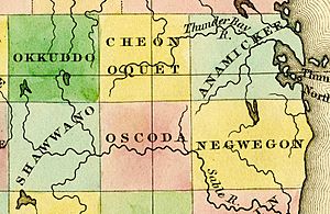
Alcona County was created by the state government on April 1, 1840. At first, it was named Negwegon County. This name honored a famous Chippewa chief, also known as "Little Wing." He was a friend and helper to the Americans during the War of 1812.
The county's name changed to Alcona County on March 8, 1843. A man named Henry Rowe Schoolcraft created the name. He combined parts of words from Native American languages with words from Arabic, Greek, and Latin. Together, these parts mean "fine or excellent plain." Schoolcraft was an important US Indian agent and geographer.
For a while, Alcona County was connected to other counties for things like taxes and legal matters. It was first linked to Mackinac County. Later, it was connected to Cheboygan County, then Alpena County, and Iosco County, before going back to Alpena County.
Harrisville Township was set up in 1860 and included the whole county. The county government officially started on May 8, 1869. The county's slogan, "First of 83," is on its seal. This slogan shows its alphabetical place among Michigan's 83 counties.
Geography of Alcona County
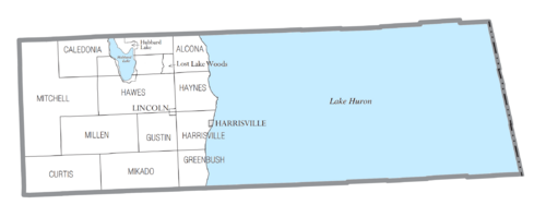
The U.S. Census Bureau says Alcona County covers about 1,791 square miles. About 675 square miles of this is land, and 1,116 square miles (62%) is water.
The land is part of the Au Sable State Forest. This area is considered part of Northern Michigan.
Alcona County has a shoreline along Lake Huron. Through Lake Huron, Alcona County shares a water boundary with the Canadian province of Ontario. The Au Sable River flows through the southwest part of the county.
Lakes in Alcona County
Many lakes are found in Alcona County, including:
- Lake Huron
- Alcona Lake
- Badger Lake
- Bear Lake
- Brownlee Lake
- Byron Lake
- Cedar Lake
- Clear Lake
- Crooked Lake
- Crystal Lake
- Curtis Lake
- Honawan Lake
- Horseshoe Lake
- Hubbard Lake, one of Michigan's largest inland lakes.
- Hunter Lake
- Indian Lake
- Jenkins lake
- Jewell Lake
- Lost Lake
- North Hoist Lake
- North Lake
- O'Brien Lake
- Poplar Lake
- Reid Lake
- South Hoist Lake
- Tompson Lake
Neighboring Counties
Alcona County is next to these counties:
- Alpena County - to the north
- Iosco County - to the south
- Ogemaw County - to the southwest
- Oscoda County - to the west
- Montmorency County - to the northwest
Protected Natural Areas
- Huron National Forest (part of it is in Alcona County)
Communities in Alcona County
Cities
- Harrisville (This is the county seat, where the main county government offices are.)
Villages
Townships
These are smaller local government areas within the county:
Census-Designated Places
These are areas that the U.S. Census Bureau defines for gathering population data:
Other Small Towns and Areas
Ghost Town
- Bamfield (A town that no longer exists or has very few people.)
Population Information
| Historical population | |||
|---|---|---|---|
| Census | Pop. | %± | |
| 1860 | 185 | — | |
| 1870 | 696 | 276.2% | |
| 1880 | 3,107 | 346.4% | |
| 1890 | 5,409 | 74.1% | |
| 1900 | 5,691 | 5.2% | |
| 1910 | 5,703 | 0.2% | |
| 1920 | 5,912 | 3.7% | |
| 1930 | 4,989 | −15.6% | |
| 1940 | 5,463 | 9.5% | |
| 1950 | 5,856 | 7.2% | |
| 1960 | 6,352 | 8.5% | |
| 1970 | 7,113 | 12.0% | |
| 1980 | 9,740 | 36.9% | |
| 1990 | 10,145 | 4.2% | |
| 2000 | 11,719 | 15.5% | |
| 2010 | 10,942 | −6.6% | |
| 2020 | 10,167 | −7.1% | |
| 2023 (est.) | 10,489 | −4.1% | |
| US Decennial Census 1790-1960 1900-1990 1990-2000 2010-2018 |
|||
In 2010, there were 10,942 people living in Alcona County. Most of them (97.9%) were White. About 0.6% were Native American, and smaller groups were Asian or Black. About 1.1% of the people were Hispanic or Latino. By 2020, the population was 10,167 people.
Education in Alcona County
Alcona County has three main public school districts. These school districts do not always follow the exact county or town borders. Only one district, Alcona Community Schools, is fully inside the county. It had 690 students in the 2021-2022 school year.
Some students in the southern part of the county go to Oscoda Area Schools. This district is in the next county over, Iosco. Students in the western part of the county, in Mitchell Township, go to Fairview Area School District. This district is based in Oscoda County. Each school district works with a different larger education service district. Most students in Alcona County are served by the Alpena–Montmorency–Alcona Education Service District.
School Districts
- Alcona Community Schools
- Fairview Area School District
- Oscoda Area Schools
Media in Alcona County
Newspapers
- The Alcona County Review is the local newspaper in Harrisville. It has been serving the community since 1877.
- The Alpena News covers the northeastern part of Michigan's lower peninsula.
- The Oscoda Press is a weekly newspaper for southern Alcona County and northern Iosco County.
- Larger newspapers like the Detroit Free Press and The Detroit News are also available.
Radio
- WXTF-LP
Historical Markers
These are special signs that tell about important places or events:
- Greenbush School
- West Harrisville Depot in Lincoln
- Springport Inn, Springport home of Civil War Captain Joseph VanBuskirk.
Parks and Recreation
Alcona County has a senior citizens center building that opened in the 1940s. There are plans to build a new, updated center for senior citizens.
Transportation
Highways
 US 23 — This highway runs along the Lake Huron shore. It's called the Sunrise Side Coastal Highway. It connects with M-72 in Harrisville. US 23 is the closest highway to get to Alpena and Mackinaw City.
 M-65 — This highway runs along the western side of the county.
 M-72 — In 1936, downtown Harrisville became the end point of the 133-mile M-72. This highway goes all the way across the lower peninsula from Empire, Michigan. It is one of only three highways that truly cross the peninsula.
 F-30 — This road runs from US 23 at Greenbush through Mikado to M-65 at Glennie.
 F-32 —
 F-41 — This road runs north–south from US 23 at Oscoda to US 23 south of Ossineke.
Airport
Alcona County helped develop the Oscoda-Wurtsmith Airport. This airport became public in 1993. It is located on part of the old Wurtsmith Air Force Base in Oscoda Township, Michigan, which is in the nearby Iosco County, Michigan. The airport is mostly used for cargo and small planes. It is open 24 hours a day in almost all weather conditions.
See also
 In Spanish: Condado de Alcona para niños
 | Aurelia Browder |
 | Nannie Helen Burroughs |
 | Michelle Alexander |


