Alpena County, Michigan facts for kids
Quick facts for kids
Alpena County
|
||
|---|---|---|
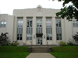
Alpena County Courthouse
|
||
|
||
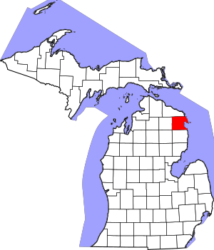
Location within the U.S. state of Michigan
|
||
 Michigan's location within the U.S. |
||
| Country | ||
| State | ||
| Founded | February 7, 1857 | |
| Seat | Alpena | |
| Largest city | Alpena | |
| Area | ||
| • Total | 1,695 sq mi (4,390 km2) | |
| • Land | 572 sq mi (1,480 km2) | |
| • Water | 1,123 sq mi (2,910 km2) 66%% | |
| Population
(2020)
|
||
| • Total | 28,907 | |
| • Estimate
(2023)
|
28,904 |
|
| • Density | 66/sq mi (25/km2) | |
| Time zone | UTC−5 (Eastern) | |
| • Summer (DST) | UTC−4 (EDT) | |
| Congressional district | 1st | |
Alpena County is a county in the state of Michigan, USA. It's located in the northern part of Michigan. In 2020, about 28,907 people lived here. The main city and county seat is Alpena. Alpena County is also part of a larger area called the Alpena, MI Micropolitan Statistical Area.
Contents
History
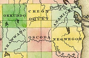
Alpena County was first created by the Michigan government in 1840. Back then, it had a different name: Anamickee County.
In 1843, its name was changed to Alpena County. The name "Alpena" was made up by a person named Henry Schoolcraft. It's a word that sounds like it comes from Native American languages, and it means "a good partridge country." Many other counties in Michigan were also renamed around this time.
The original Native American people living in this area were the Thunder Bay Band of Chippewa and Ottawa. In the mid-1800s, they joined with the Mackinac Bands of Chippewa and Ottawa Indians. Alpena County officially became an organized county in 1857.
Geography
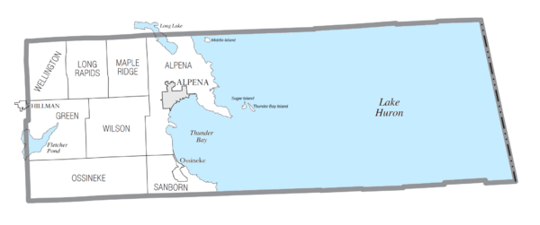
Alpena County is in the northeast part of Michigan's Lower Peninsula, which looks like a mitten. To the east, you'll find Lake Huron and Thunder Bay. Other counties nearby include Alcona County to the south, Oscoda County to the southwest, Montmorency County to the west, and Presque Isle County to the north.
Most of the county's water flows into the Thunder Bay River. A large part of the land is covered by the Mackinaw State Forest. Right off the coast, there's a special underwater area called the Thunder Bay National Marine Sanctuary.
A cool fact about Alpena County is that the 45th parallel line crosses through it. This means the county is exactly halfway between the North Pole and the equator!
Some islands in Thunder Bay are part of the Michigan Islands National Wildlife Refuge. You can also find automated lighthouses on Middle Island and Thunder Bay Island.
Geographic features
Neighboring counties
- Alcona County - south
- Oscoda County - southwest
- Montmorency County - west
- Presque Isle County - north
Main roads
 US 23 runs along the Lake Huron shoreline and goes through Alpena. It continues north past Long Lake and Grand Lake. It then goes through Rogers City, Michigan, and Cheboygan, Michigan, finally ending at Mackinaw City, Michigan. There, it connects to I-75 and the Mackinac Bridge.
 M-32 is a road that crosses the Lower Peninsula from Lake Michigan to Lake Huron. It ends in downtown Alpena where it meets US 23.
 M-65 is a more direct route south than US 23. It also goes north to Rogers City.
Protected areas
Communities
City
- Alpena (This is the county seat, where the main government offices are.)
Village
- Hillman (partially)
Charter township
Civil townships
- Green Township
- Long Rapids Township
- Maple Ridge Township
- Ossineke Township
- Sanborn Township
- Wellington Township
- Wilson Township
Census-designated place
Other small communities
Population Information
| Historical population | |||
|---|---|---|---|
| Census | Pop. | %± | |
| 1860 | 290 | — | |
| 1870 | 2,756 | 850.3% | |
| 1880 | 8,789 | 218.9% | |
| 1890 | 15,581 | 77.3% | |
| 1900 | 18,254 | 17.2% | |
| 1910 | 19,965 | 9.4% | |
| 1920 | 17,869 | −10.5% | |
| 1930 | 18,574 | 3.9% | |
| 1940 | 20,766 | 11.8% | |
| 1950 | 22,189 | 6.9% | |
| 1960 | 28,556 | 28.7% | |
| 1970 | 30,708 | 7.5% | |
| 1980 | 32,315 | 5.2% | |
| 1990 | 30,605 | −5.3% | |
| 2000 | 31,314 | 2.3% | |
| 2010 | 29,598 | −5.5% | |
| 2020 | 28,907 | −2.3% | |
| 2023 (est.) | 28,904 | −2.3% | |
| U.S. Decennial Census 1790-1960 1900-1990 1990-2000 2010-2018 |
|||
In 2010, Alpena County had a population of 29,598 people. This was a small decrease from the year 2000. By the 2020 census, the population was 28,907.
There were about 12,791 households in the county in 2010. A household is a group of people living together. About 25.3% of these households had children under 18 living with them.
Most people in Alpena County are White (97.5%). Smaller groups include Native American, Asian, Black or African American, and people of two or more races. About 1.0% of the population was Hispanic or Latino.
The average age of people in Alpena County in 2010 was 46 years old. About 20.9% of the population was under 18 years old.
Media
The Alpena News is the daily newspaper for Alpena County and much of Northeast Michigan. For more information about other media, you can check the Alpena, Michigan page.
Arts and culture
Museums
- Besser Museum for Northeast Michigan
- Thunder Bay National Marine Sanctuary
Historical markers
There are seven special historical markers in Alpena County that tell about important places or events:
- Alpena County Courthouse
- Alpena City Hall
- The Daniel Carter Family
- First Congregational Church [Alpena]
- Monarch Mill
- St. Bernard Catholic Church
- World's Largest Cement Plant
See also
 In Spanish: Condado de Alpena para niños
 | Toni Morrison |
 | Barack Obama |
 | Martin Luther King Jr. |
 | Ralph Bunche |


