
Interstate 75 in Michigan facts for kids
Quick facts for kids
|
||||
|---|---|---|---|---|
|
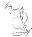
I-75 highlighted in red
|
||||
| Route information | ||||
| Maintained by MDOT and MBA | ||||
| Length | 395.916 mi (637.165 km) | |||
| Existed | 1959–present | |||
| History | Completed November 1, 1973 | |||
| Tourist routes |
||||
| Major junctions | ||||
| South end | ||||
|
||||
| North end | International Bridge in Sault Ste. Marie | |||
| Location | ||||
| Counties: | Monroe, Wayne, Oakland, Genesee, Saginaw, Bay, Arenac, Ogemaw, Roscommon, Crawford, Otsego, Cheboygan, Emmet, Mackinac, Chippewa | |||
| Highway system | ||||
| Main route of the Interstate Highway System Main • Auxiliary • Business Michigan State Trunkline Highway System
|
||||

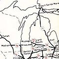
Interstate 75 (I-75) is a very long highway that goes from Miami, Florida, all the way north to Sault Ste. Marie in Michigan. In Michigan, I-75 starts at the Ohio border and travels north. It passes through big cities like Detroit, Pontiac, and Bay City. Then, it crosses the amazing Mackinac Bridge and ends at the Canadian border in Sault Ste. Marie.
This freeway is about 396 miles (637 km) long in Michigan. It goes through many different types of land. You'll see farmlands in the south, thick forests up north, busy suburbs, and the heart of Detroit. I-75 also uses three huge bridges to cross major bodies of water. Several smaller highways connect to I-75, and some special "business routes" help drivers get into downtown areas.
I-75 has different names along its path. In the south, it was once called the Detroit–Toledo Expressway. In Detroit, it's known as the Fisher Freeway or the Walter P. Chrysler Freeway, named after important people in the car industry. Near the Mackinac Bridge, parts are called the G. Mennen Williams Freeway or the Prentiss M. Brown Freeway. These names honor politicians who helped build the bridge. The entire I-75 in Michigan is also called the Tuskegee Airmen Memorial Highway, honoring the brave Tuskegee Airmen. Officially, it's the American Legion Memorial Highway. Parts of I-75 are also part of the four Great Lakes Circle Tours.
Long ago, Native American trails followed the same general path as I-75. Later, these trails became early state highways. In the 1920s, some of these roads became part of the United States Numbered Highway System. In the 1950s, people thought about building a "Michigan Turnpike" as a toll road. But after a new law in 1956, a free Interstate Highway was planned instead. Construction started in 1957, and I-75 was finished in 1973. Since then, parts of the freeway have been improved, like the Zilwaukee Bridge and connections to the Ambassador Bridge in Detroit.
Contents
Driving Through Michigan
I-75 is often called "Michigan's Main Street." It's part of the National Highway System, which is a group of roads important for the country's economy and travel. This freeway is the busiest in Michigan. For example, in Detroit, over 194,000 vehicles used a part of it each day in 2010. In contrast, a quiet section in the Upper Peninsula only had about 3,200 vehicles daily.
I-75 is the only highway that goes through both of Michigan's main land areas: the Upper and Lower peninsulas. In the southern part of the state, I-75 has between six and ten lanes. Other parts have four to six lanes.
From Ohio to Detroit

When I-75 enters Michigan from Ohio, it's in Monroe County. Here, it follows the Lake Erie Circle Tour (LECT) near Lake Erie. The freeway runs close to the lake and passes by small towns like Luna Pier. It goes past Monroe and crosses the River Raisin. Further north, I-75 goes through farmlands. Near Newport, another highway, I-275, splits off. I-75 then enters Wayne County and starts running near the Detroit River.
As I-75 gets closer to Detroit, the area changes from farms to suburban neighborhoods. The LECT leaves I-75 here. The freeway passes through towns like Taylor and Lincoln Park. It crosses the Ecorse River and goes through industrial areas. Then, it crosses the River Rouge as it enters Detroit.
In Detroit, I-75 runs near the Ambassador Bridge, which connects to Canada. The freeway turns sharply here and meets other major highways like I-96, M-10, and M-5. I-75 also passes by famous sports stadiums like Little Caesars Arena, Comerica Park, and Ford Field. These are home to Detroit's professional hockey, baseball, and football teams.
Detroit to the Tri-Cities

After leaving downtown Detroit, I-75 turns northwest. This part is called the Chrysler Freeway. It passes near Wayne State University and crosses I-94. The Chrysler Freeway goes between Hamtramck and Highland Park, which are cities surrounded by Detroit. I-75 continues through Detroit's northern neighborhoods. North of 8 Mile Road, the freeway enters Oakland County. In Hazel Park, there's a curve that has been known for many accidents.
Further north, I-75 meets I-696. The freeway then goes north into Troy and Auburn Hills. It zig-zags around Pontiac. Near the M-59 exit, I-75 passes the headquarters for Chrysler cars. It also runs near the former home of The Palace of Auburn Hills, a famous sports arena. The freeway continues through suburban areas, then changes back to a rural, wooded setting as it enters Genesee County.
Near Grand Blanc, the landscape becomes suburban again. I-475 splits off to go around the east side of Flint. Then, I-75 joins with US-23. Together, I-75/US-23 goes around the west side of Flint. They meet I-69 near the airport. The freeway continues north, passing the end of I-475. It goes by Clio and Birch Run, which has a big outlet mall. From there, the highway travels through farmlands in Saginaw County.
Central Michigan

I-75/US-23 enters the suburban area known as the Tri-Cities at Bridgeport. It goes north, passing east of downtown Saginaw. Another highway, I-675, splits off to go into downtown. I-75 then curves northwest to cross the Saginaw River on the Zilwaukee Bridge in Zilwaukee. North of the river, I-675 rejoins I-75. The freeway continues into Bay County, passing west of Bay City. Here, it meets the end of the US-10 freeway. I-75/US-23 then curves northwest again, going around Kawkawlin and continuing north through farmlands. West of Standish, US-23 splits off to follow the Lake Huron shoreline, and I-75 turns northwest to go inland.
West of Sterling, the scenery changes to forests. I-75 continues northwest through Arenac County and into Ogemaw County. It goes around the west side of West Branch. On the northwest side of that city, M-55 joins I-75, and they travel west together into Roscommon County. East of Prudenville, M-55 leaves the freeway. I-75 turns north, curving around Houghton and Higgins lakes. Then, it turns northwest again, bypassing Roscommon to the south. About 5 miles (8 km) north of the county line, I-75 meets the northern end of US-127.
Northern Michigan

After the US-127 exit, I-75 turns north and passes east of Grayling. There are two exits for a business loop (BL I-75) that goes into Grayling. The southern exit is only for northbound I-75 traffic to enter the business loop, and for traffic leaving the business loop to go southbound on I-75. The northern exit for BL I-75 also connects to M-93 and provides access to Hartwick Pines State Park.
Entering Otsego County, I-75 continues north through northern Michigan forests. It passes east of Waters and Otsego Lake. North of exit 279, I-75 goes by the Gaylord Regional Airport and crosses the 45th Parallel. This is the halfway point between the Equator and the North Pole! The freeway then goes along the west side of Gaylord and continues through forests. North of Vanderbilt, I-75 enters Cheboygan County and is called the G. Mennen Williams Freeway.
I-75 continues north through Cheboygan County, passing Indian River and crossing the river of the same name. North of town, the freeway goes between Burt and Mullett lakes before meeting the southern end of M-27. This highway leads to Topinabee and Cheboygan. I-75 continues through tree farms and farms in rural Cheboygan County. Cheboygan can be reached by county highways C-64 and C-66. North of C-66, I-75 turns northwest. The freeway meets the northern end of US-31 and picks up the Lake Michigan Circle Tour (LMCT) before entering Emmet County near Mackinaw City. I-75 then runs next to the county line on the west side of the village, meeting the northern end of US-23. After that, the Lake Huron Circle Tour (LHCT) joins I-75. There's one more exit before I-75 starts its climb onto the Mackinac Bridge.
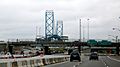
Mackinac Bridge

The Mackinac Bridge carries I-75 across the Straits of Mackinac. These straits separate Michigan's Upper and Lower peninsulas and connect Michigan and Huron. The Mackinac Bridge Authority (MBA) takes care of the bridge and collects a toll from drivers. As of 2012, it cost $4 for cars to cross. The MBA also helps drivers who are afraid of bridges by driving their cars across for them. Because the bridge is usually only for cars, bicyclists and snowmobiles need to be shuttled across for a fee. The MBA has a small police department to patrol the bridge and help drivers. They also have radio stations (AM 530 and AM 1610) that share bridge conditions and travel information.
Upper Peninsula

North of the Mackinac Bridge, I-75 passes west of downtown St. Ignace. There's an exit north of the toll plaza that marks the eastern end of US-2 and the start of a business loop for St. Ignace (BL I-75). The LMCT follows US-2, while the LHCT follows BL I-75 through town. The freeway curves around Chain Lake and the Mackinac County Airport. It meets the northern end of the business loop near Castle Rock, where the LHCT rejoins I-75. As it continues north, M-123 joins from the west. I-75 crosses the Carp River and follows the shores of St. Martin Bay before meeting M-134. At that exit, the LHCT leaves again to go east. In this area, the freeway continues northeast through the Hiawatha National Forest.
I-75 crosses the Pine River before entering Chippewa County. The freeway goes more north, passing under M-48 without an exit. Further north, M-48 connects I-75 with Rudyard, and the freeway turns back northeast. About 5 miles (8 km) northeast of Rudyard, I-75 passes the Chippewa County International Airport, which used to be Kincheloe Air Force Base. North of there, in Dafter, the freeway meets M-28. Beyond that exit, I-75 picks up the Lake Superior Circle Tour (LSCT) designation, which it carries all the way north. On the south side of Sault Ste. Marie, the freeway meets a business spur (BS I-75) and picks up the LHCT one more time. I-75 goes around the west side of the city, passes the Sault Ste. Marie Municipal Airport and Lake Superior State University. Finally, it reaches the customs and toll plazas for the International Bridge. From there, I-75 crosses the two-lane bridge and ends at the Canadian border. As of 2012, the toll to cross the bridge was $3 for cars.
History of I-75
From Trails to Highways

Before Michigan became a state, the first travel paths were Native American trails. For example, the French-Indian Trail ran through southeastern Michigan. The Saginaw Trail went north from Detroit to the Saginaw area. Another path, the Cheboygan Trail, ran parallel to where I-75 is now. In the Upper Peninsula, an extension of the Mackinac Trail connected St. Ignace and Sault Ste. Marie.
In the 1800s, private companies built "plank roads" or turnpikes, which were often made of oak planks. Many of these replaced the old Indian trails. By the early 1900s, most of these plank roads were gone, and the state took them over.
The Michigan State Trunkline Highway System was created in 1913. Parts of this system were built along the future I-75 route. In 1919, these highways were marked on maps for the first time. When the United States Numbered Highway System was formed in 1926, many of these Michigan highways became part of the national system, like US-2, US-10, US-24, US-25, and US-27.
Building the Freeways
By 1945, a divided highway was opened near the Ohio state line. After World War II, Michigan planned to turn several highways into freeways. The path of what would become I-75 was included in these plans.
In the 1950s, the Michigan Turnpike Authority wanted to build a toll freeway in the state. This proposed turnpike would have run from near Toledo, through Detroit and Saginaw, all the way to the Mackinac Bridge. However, the state highway commissioner, Charles Ziegler, didn't want a separate agency building roads. He worked to stop the turnpike plans, even saying the state would build a free freeway next to it. Trucking companies also didn't like tolls and preferred a small gas tax increase.
When the federal government passed the Federal Aid Highway Act of 1956, it allowed for free Interstate Highways. This made the Michigan Turnpike plans less likely to happen. By 1958, the Michigan Townships Association called for the toll road authority to be shut down. In 1962, the state legislature finally ended the agency that wanted to build the turnpike.
The first parts of I-75 freeway opened in 1957 near the Ohio state line. The Mackinac Bridge opened on November 1, 1957. In 1959, I-75 signs were first put up along the Detroit–Toledo Expressway.
In 1960, sections of the freeway opened from Indian River north to Mackinaw City and from St. Ignace to Evergreen Shores. In 1961, the first Zilwaukee Bridge, a drawbridge over the Saginaw River, opened. This bridge would often cause long traffic jams when it opened for ships. That same year, a section of I-75 near Grayling opened.
By the end of 1962, more sections of I-75 were completed, including the part between Gaylord and Indian River. The International Bridge also opened in Sault Ste. Marie on October 31, 1962. In 1963, the remaining gaps in the freeway across the Upper Peninsula were finished. A section of I-75 in Northern Michigan was even named the most scenic new highway in the US by Parade magazine that year.
By 1970, I-75 through Detroit was completed. The final section of I-75 in Michigan, between Alger and Roscommon, opened on November 1, 1973.
Since 1973, some changes have been made. From 1973 to 1975, I-75 was made wider (from four to six lanes) in some areas. In 1986, US-10 was shortened, so it no longer ran with I-75. In 1988, the old Zilwaukee Bridge was replaced by a much taller, new bridge. In 2014, all of I-75 in Michigan was named the Tuskegee Airmen Memorial Highway. In 2017, the speed limit on I-75 between Bay City and Sault Ste. Marie was raised from 70 to 75 mph (113 to 121 km/h), except on the Mackinac Bridge.
Gateway Project

Starting in 2008, a part of I-75 in Detroit was completely closed. This was for the Ambassador Gateway Project, which aimed to better connect I-75 and I-96 to the Ambassador Bridge. Traffic was rerouted during this time. The freeway reopened in June 2009. The project was finished in September 2012.
Future of I-75
A section of I-75 in Oakland County will get special lanes called high-occupancy vehicle lanes (HOV lanes). These lanes will be for cars with multiple people during busy times (6 a.m. to 9 a.m. and 3 p.m. to 6 p.m.). These HOV lanes are part of a big project to modernize I-75 and are expected to open in late 2023.
Freeway Names
.png)

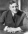
I-75 has six different names in Michigan. The very first part from the Ohio border to Detroit is called the Detroit–Toledo Expressway. The section through southern and central Detroit is known as the Fisher Freeway. It was named in 1970 after the Fisher Brothers, who started Fisher Body, a car company. After a curve in downtown Detroit, I-75 becomes the Walter P. Chrysler Freeway. This part is named after Walter P. Chrysler, who founded the Chrysler car company.
The entire length of I-75 in Michigan is officially the American Legion Memorial Highway. This name honors the American Legion, a group for military veterans.
Two other parts of I-75 near the Straits of Mackinac were named in 1976. The section from the Cheboygan–Otsego county line north to the Mackinac Bridge is named for G. Mennen Williams, a former governor of Michigan. The part in Mackinac County, from the northern end of the Mackinac Bridge, is named for Prentiss M. Brown. He was a former Congressman and Senator who helped with the Mackinac Bridge project.
Famous Bridges on I-75
I-75 uses three very important and large bridges in Michigan.
Zilwaukee Bridge

The first big bridge is the Zilwaukee Bridge near Saginaw. The original bridge there, built in 1960, was a drawbridge. This meant it had to open for ships, causing traffic jams on I-75 that could last for hours! A new, much higher bridge was approved in 1974. Construction started in 1979. In 1982, there was a big accident during construction when a part of the bridge collapsed. This delayed the project. The new Zilwaukee Bridge was supposed to cost $76.8 million and be finished by 1983. But it ended up costing $131.3 million and opened on September 19, 1988. This bridge is the largest concrete bridge of its kind in the United States.
Mackinac Bridge

The second famous bridge is the Mackinac Bridge, often called the "Mighty Mac." It connects Michigan's two peninsulas across the Straits of Mackinac. People first thought about building a bridge here in 1888. Car ferry service started in 1923 to cross the straits. An authority was created in 1934 to study building a permanent bridge. Early plans involved connecting several islands. However, the collapse of another bridge (the Tacoma Narrows Bridge) and World War II delayed plans.
The current bridge authority was created in 1950. They were allowed to sell bonds to pay for construction in 1952. The bridge cost $99.8 million. Construction started in 1954, and the Mackinac Bridge opened to traffic on November 1, 1957. The bridge is very long, with a main span of 3,800 feet (1,158 meters). The total length of the structure is about 5 miles (8 km)! It has two tall towers, 555 feet (169 meters) high, and ships can pass underneath with 155 feet (47 meters) of clearance. In 2000, the bridge was named "Michigan's No. 1 Civil Engineering Project of the 20th Century."
International Bridge

The northernmost of the three big bridges on I-75 is the International Bridge. This bridge connects the two cities named Sault Ste. Marie: one in Michigan and one in Ontario, Canada. Governments from both sides created a bridge authority in 1935. Construction started on September 16, 1960.
The International Bridge is almost 3 miles (5 km) long. It has spans over the American and Canadian shipping channels for the Soo Locks and the St. Marys River. The bridge cost $20 million and opened to traffic on October 31, 1962.
Related Highways
Michigan has four special Interstate Highways that connect to I-75.
- I-275 is a loop that helps drivers get to western Wayne County and the Detroit Metropolitan Wayne County Airport.
- I-375 was once the shortest signed Interstate in the country. It serves the downtown Detroit area.
- I-475 is known as the UAW Freeway. It goes through downtown Flint, while I-75 goes around the west side of the city.
- I-675 is a loop into the city of Saginaw. It used to be an alternate route for I-75 when the old drawbridge over the Saginaw River was still in use.
Besides these, there are eight "business routes" related to I-75 in Michigan. These special routes help drivers get into the downtown areas of cities like Pontiac, Bay City, West Branch, Roscommon, Grayling, Gaylord, St. Ignace, and Sault Ste. Marie.
Images for kids
-
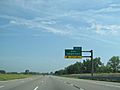
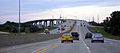
I-75 northbound approaching exit 2 in Monroe County
-
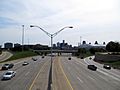
Looking south along the Chrysler Freeway to the Detroit skyline
-
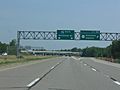
Split between I-75 and US 23 west of Standish
-
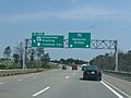
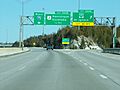
Exit 254 south of Grayling
-
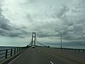
I-75 crossing the Mackinac Bridge
-
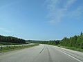
North of St. Ignace
-
Map of the pre-statehood Indian trails
-
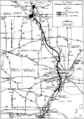
1955 map of the proposed Michigan Turnpike
-
Markers such as this one bearing the state name originally used when I-75 was first signed
-
1958 numbering plan for Michigan's Interstates
-
Construction in 2007 during the Gateway Project
-

Portrait of Walter P. Chrysler
-
Portrait of Prentiss M. Brown
-
Zilwaukee Bridge
-
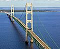
Aerial photograph of the Mackinac Bridge
-
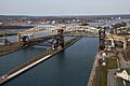
Part of the International Bridge
-
Southern end of the business loop for St. Ignace

.svg)
.jpg)

| County | Location | mi | km | Exit | Destinations | Notes |
|---|---|---|---|---|---|---|
| Monroe | Erie Township | 0.000 | 0.000 | Ohio state line; LECT continues south into Ohio | ||
| 1.587 | 2.554 | 2 | Summit Street | Southbound exit and northbound entrance | ||
| 2.547 | 4.099 | 2 | Erie, Temperance | Northbound exit and southbound entrance; unsigned Connector 75 (Summit Street) | ||
| 4.610 | 7.419 | 5 | Erie Road – Erie, Temperance | |||
| Luna Pier | 5.785 | 9.310 | 6 | Luna Pier | Connects to Luna Pier Road | |
| La Salle Township | 8.629 | 13.887 | 9 | South Otter Creek Road – La Salle | ||
| Monroe Charter Township | 11.357 | 18.277 | 11 | La Plaisance Road – Downtown Monroe | ||
| Monroe | 13.452 | 21.649 | 13 | Front Street – Monroe | ||
| 13.583 | 21.860 | 14 | Elm Avenue | |||
| Frenchtown Charter Township | 15.230 | 24.510 | 15 | Dixie Highway – Downtown Monroe | Former M-50 | |
| 18.040 | 29.033 | 18 | Nadeau Road | |||
| 20.310 | 32.686 | 20 | To Detroit Metro Airport; southern terminus of I-275 | |||
| Berlin Charter Township | 21.463 | 34.541 | 21 | Swan Creek Road – Newport | To Newport Road | |
| South Rockwood | 26.342 | 42.393 | 26 | South Huron River Drive – South Rockwood | ||
| Wayne | Rockwood | 26.941 | 43.357 | 27 | North Huron River Drive – Rockwood | |
| Brownstown Charter Township | 27.680 | 44.547 | 28 | Northbound exit and southbound entrance; southern terminus of M-85 and northern end of LECT concurrency | ||
| Flat Rock | 28.824 | 46.388 | 29 | Gibraltar, Flat Rock | Signed as exits 29A (Gibraltar) and 29B (Flat Rock) southbound; connects to Gibraltar Road | |
| Woodhaven | 31.821 | 51.211 | 32 | West Road – Trenton, Grosse Ile, Woodhaven, Brownstown Township | Signed as exits 32A (east, Trenton, Grosse Ile) and 32B (west, Woodhaven, Brownstown Township) | |
| Brownstown Charter Township | 33.707– 33.783 |
54.246– 54.368 |
34A | Dix–Toledo Highway | Signed as exit 34 northbound; converted to complete interchange in 2012 | |
| 34.012 | 54.737 | 34B | Sibley Road | Southbound exit and northbound entrance; missing connections provided via exit 34A | ||
| Taylor | 34.794 | 55.996 | 35 | Northbound exit to northbound US 24 and southbound entrance from southbound US 24 only; unsigned Connector 240 | ||
| 35.961 | 57.874 | 36 | Eureka Road | |||
| Taylor–Southgate city line | 36.800– 37.311 |
59.224– 60.046 |
37 | Allen Road, Northline Road | ||
| Lincoln Park | 39.875 | 64.173 | 40 | Dix Highway | No access from southbound I-75 to northbound Dix Highway, northbound Dix Highway to southbound I-75, or southbound Dix Highway to northbound I-75 | |
| 40.686– 40.711 |
65.478– 65.518 |
41 | ||||
| Melvindale | 41.827 | 67.314 | 42 | Outer Drive | ||
| Detroit | 42.999 | 69.200 | 43 | Southern end of LECT concurrency; signed as exits 43A (Schaefer Highway south, M-85 [Fort Street]) and 43B (Schaefer Highway north) southbound; former northern terminus of M-85 | ||
| 44.862 | 72.198 | 44 | Dearborn Street | Northbound exit and southbound entrance | ||
| 45.594 | 73.376 | 45 | ||||
| 46.484 | 74.809 | 46 | Livernois Avenue | Interchange permanently closed; to be replaced in 2024 by currently under construction ramps to/from the United States Port of Entry for the Gordie Howe International Bridge | ||
| 47.276 | 76.083 | 47A | Clark Street | Former M-3 | ||
| 48.020 | 77.281 | 47B | Northbound exit and southbound entrance; northern end of LECT concurrency; to Highway 3 | |||
| 48.062 | 77.348 | 47C | No northbound entrance from Vernor Highway; signed as exits 47C (Vernor Highway) and 47B (Ambassador Bridge) southbound | |||
| 47.894– 49.108 |
77.078– 79.032 |
48 | Eastern terminus of I-96 | |||
| 49.878– 49.108 |
80.271– 79.032 |
49 | Signed as exits 49A (Rosa Parks Boulevard) and 49B (M-10) southbound | |||
| 50.171 | 80.742 | 50 | Access to Comerica Park, Ford Field, Fox Theatre, and Little Caesars Arena | |||
| 50.581 | 81.402 | 51A | No southbound entrance; exit eliminated in 1999; northbound entrance still exists | |||
| 50.717 | 81.621 | 51B | No entrance from northbound M-3 | |||
| 50.864– 50.896 |
81.858– 81.909 |
51C | Northern terminus of I-375; 25 mph (40 km/h) speed advisory northbound | |||
| 51.551– 51.560 |
82.963– 82.978 |
52 | Mack Avenue | |||
| 52.291– 52.305 |
84.154– 84.177 |
53A | Warren Avenue | |||
| 52.853– 52.870 |
85.059– 85.086 |
53B | Exit 216A on I-94 | |||
| 53.581 | 86.230 | 54 | East Grand Boulevard, Clay Avenue | |||
| Hamtramck | 54.212– 54.941 |
87.246– 88.419 |
55 | Holbrook Avenue, Caniff Avenue | ||
| Detroit | 55.965 | 90.067 | 56 | Signed as exits 56A (east) and 56B (west) | ||
| 56.741– 56.752 |
91.316– 91.333 |
57 | McNichols Road | |||
| 57.822 | 93.055 | 58 | 7 Mile Road | |||
| Wayne–Oakland county line | Detroit–Hazel Park city line | 58.811– 58.819 |
94.647– 94.660 |
59 | ||
| Oakland | Hazel Park | 59.918– 60.104 |
96.429– 96.728 |
60 | John R. Road, 9 Mile Road | |
| Hazel Park–Ferndale– Madison Heights–Royal Oak city quadripoint |
61.183– 61.207 |
98.464– 98.503 |
61 | Exit 18 on I-696 | ||
| Royal Oak–Madison Heights city line | 62.189 | 100.083 | 62 | 11 Mile Road | ||
| Madison Heights | 63.180 | 101.678 | 63 | 12 Mile Road | To be reconstructed into a diverging diamond interchange in 2022 | |
| Madison Heights–Troy city line | 65.211 | 104.947 | 65 | 14 Mile Road | Reconstructed into a diverging diamond interchange in 2020 | |
| Troy | 67.429 | 108.516 | 67 | Rochester Road | ||
| 68.972 | 111.000 | 69 | Big Beaver Road | Reconstructed into a diverging diamond interchange in 2020 | ||
| 71.593 | 115.218 | 72 | Crooks Road | Indirect access to Crooks Road via trumpet interchange with Corporate Drive | ||
| Bloomfield Township | 74.138 | 119.314 | 74 | Adams Road | ||
| 75.179– 76.063 |
120.989– 122.412 |
75 | Signed only as Square Lake Road southbound; southern terminus of BL I-75 | |||
| Auburn Hills | 77.351– 77.369 |
124.484– 124.513 |
77 | Signed as exits 77A (east) and 77B (west); exit 40 on M-59 | ||
| 78.547 | 126.409 | 78 | Chrysler Drive | Access to Featherstone Road | ||
| 79.040 | 127.203 | 79 | University Drive – Rochester | Reconstructed into the first diverging diamond interchange in Michigan in 2015 | ||
| 80.994 | 130.347 | 81 | Signed as only M-24 northbound; double trumpet interchange; northern terminus of BL I-75 and southern terminus of M-24 | |||
| 82.911 | 133.432 | 83 | Joslyn Road | Signed as exits 83A (north) and 83B (south) southbound; east entrance to Great Lakes Crossing Outlets | ||
| 84.128 | 135.391 | 84 | Baldwin Road | Signed as exits 84A (north) and 84B (south) northbound; west entrance to Great Lakes Crossing Outlets | ||
| Independence Township | 88.752 | 142.832 | 89 | Sashabaw Road | Signed as exits 89A (north) and 89B (south) northbound | |
| 90.812 | 146.148 | 91 | ||||
| Springfield Township | 92.653 | 149.111 | 93 | Northern terminus of US 24 | ||
| 97.995 | 157.708 | 98 | East Holly Road | |||
| Groveland Township | 100.963 | 162.484 | 101 | Grange Hall Road – Fenton, Ortonville | ||
| Oakland–Genesee county line | Holly– Grand Blanc township line |
105.941– 106.308 |
170.496– 171.086 |
106 | Dixie Highway Saginaw Road |
Indirect access in opposing directions via Michigan lefts; signed as Dixie Highway southbound and Saginaw Road northbound |
| Genesee | Grand Blanc Township | 108.676 | 174.897 | 108 | Holly Road – Grand Blanc | |
| 109.905 | 176.875 | 109 | Southern terminus of M-54 | |||
| 111.622– 111.899 |
179.638– 180.084 |
111 | Northbound exit and southbound entrance; southern terminus of I-475 | |||
| Mundy Township | 115.017– 115.335 |
185.102– 185.614 |
115 | Southern end of US 23 concurrency; southbound exit and northbound entrance | ||
| Flint | 116.334 | 187.221 | 116 | Signed as exits 116A (east) and 116B (west, Bishop Airport) southbound; former M-121 | ||
| Flint Township | 117.221– 117.662 |
188.649– 189.359 |
117 | Signed as exits 117A (I-69) and 117B (Miller Road); combined ramp southbound; exit 133 on I-69 | ||
| 118.756 | 191.119 | 118 | ||||
| Mount Morris Township | 121.968 | 196.288 | 122 | Pierson Road – Flushing | ||
| 123.972 | 199.514 | — | Coldwater Road | Interchange eliminated in 1967 | ||
| 125.191– 125.846 |
201.475– 202.530 |
125 | Northern terminus of I-475 | |||
| 125.992 | 202.764 | 126 | Mt. Morris | Connects to Mt. Morris Road | ||
| Vienna Township | 130.078 | 209.340 | 131 | |||
| Saginaw | Birch Run | 136.159 | 219.127 | 136 | Northern terminus of M-54; southern terminus of M-83; Frankenmuth signed northbound only | |
| Bridgeport Township | 144.562 | 232.650 | 144 | Frankenmuth, Bridgeport | Signed as exits 144A (Frankenmuth) and 144B (Bridgeport) northbound; connects to Dixie Highway | |
| Buena Vista Township | 149.285 | 240.251 | 149 | |||
| 149.593 | 240.747 | 150 | Southern terminus of I-675 | |||
| 151.765 | 244.242 | 151 | ||||
| 152.977 | 246.193 | 153 | ||||
| Saginaw River | 152.612– 154.144 |
245.605– 248.071 |
Zilwaukee Bridge | |||
| Zilwaukee | 153.922 | 247.713 | 154 | Zilwaukee | Connects to Adams Street | |
| Zilwaukee Township | 154.849– 154.875 |
249.205– 249.247 |
155 | Northern terminus of I-675 | ||
| Bay | Frankenlust Township | 160.218 | 257.846 | 160 | ||
| Monitor Township | 162.699– 162.711 |
261.839– 261.858 |
162 | Eastern terminus of US 10; western terminus of BS I-75/M-25; signed as exits 162A (east) and 162B (west); exit 140 on US 10 | ||
| 163.983 | 263.905 | 164 | Northbound exit and southbound entrance; northbound access to Wilder Road; southern terminus of Conn. M-13 | |||
| 164.775 | 265.180 | 164 | Wilder Road | Southbound exit and northbound entrance; southbound access to Conn. M-13 | ||
| Kawkawlin Township | 168.945 | 271.891 | 168 | Beaver Road | ||
| Fraser Township | 173.912 | 279.884 | 173 | Linwood Road | ||
| Pinconning Township | 181.927 | 292.783 | 181 | Pinconning Road | ||
| Arenac | Lincoln Township | 188.476– 188.518 |
303.323– 303.390 |
188 | Northern end of US 23 concurrency | |
| 190.885 | 307.200 | 190 | ||||
| Adams Township | 195.009 | 313.837 | 195 | Sterling Road | ||
| Moffatt Township | 202.817 | 326.402 | 202 | Southern terminus of M-33 | ||
| Ogemaw | Horton Township | 212.118 | 341.371 | 212 | Southern terminus of BL I-75; BL I-75 signed northbound only | |
| Ogemaw Township | 215.670 | 347.087 | 215 | Eastern end of M-55 concurrency; northern terminus of BL I-75; BL I-75 signed southbound only | ||
| Roscommon | Richfield Township | 222.821 | 358.596 | 222 | Old 76 – St. Helen | Former M-76 |
| Backus Township | 227.578 | 366.251 | 227 | Western end of M-55 concurrency; Houghton Lake signed northbound only | ||
| Higgins Township | 239.631 | 385.649 | 239 | Southern terminus of BL I-75; BL I-75, South Higgins Lake State Park, and Roscommon signed northbound only, Gladwin and Houghton Lake signed southbound only | ||
| Roscommon–Crawford county line | Gerrish–Beaver Creek township line | 244.243 | 393.071 | 244 | Northern terminus of BL I-75; North Higgins Lake State Park signed northbound only, BL I-75 and Roscommon signed southbound only | |
| Crawford | Beaver Creek Township | 250.155 | 402.585 | 249 | Southbound exit and northbound entrance only; northern terminus of US 127 | |
| Beaver Creek–Grayling township line | 251.020 | 403.978 | 251 | 4 Mile Road | ||
| Grayling | 254.028 | 408.818 | 254 | Northbound exit and southbound entrance only; southern terminus of BL I-75 | ||
| 256.131 | 412.203 | 256 | North Down River Road | Southbound exit and northbound entrance | ||
| Grayling Township | 259.191 | 417.127 | 259 | Signed as only M-93 (Hartwick Pines Road) northbound; northern terminus of BL I-75 | ||
| Maple Forest Township | 264.224 | 425.227 | 264 | Frederic, Lewiston | Connects to CR 612 | |
| Otsego | Otsego Lake Township | 270.818 | 435.839 | 270 | Waters | Connects to Marlette Road |
| Bagley Township | 279.067 | 449.115 | 279 | Former US 27; signed as only Old 27 southbound; southern terminus of BL I-75 | ||
| Gaylord | 281.953 | 453.759 | 282 | Signed as only M-32 northbound; northern terminus of BL I-75 | ||
| Vanderbilt | 290.707 | 467.848 | 290 | Vanderbilt | Connects to Old US 27 (Mill Street); eastern terminus of C-48 | |
| Cheboygan | Nunda Township | 300.967 | 484.359 | 301 | ||
| Indian River | 310.156 | 499.148 | 310 | |||
| 313.646 | 504.764 | 313 | Southern terminus of M-27 | |||
| Munro Township | 322.524 | 519.052 | 322 | |||
| Hebron Township | 326.726 | 525.815 | 326 | |||
| Mackinaw Township | 335.632 | 540.147 | 336 | Southbound exit and northbound entrance; northern terminus of US 31 and southern end of LMCT concurrency | ||
| Cheboygan–Emmet county line | Mackinaw–Wawatam township line | 337.750 | 543.556 | 337 | Nicolet Street – Mackinaw City | Northbound exit and southbound entrance; southern terminus of the former M-108 |
| Emmet | Mackinaw City | 338.434 | 544.657 | 338 | Southbound exit and northbound entrance; northern terminus of US 23; southern end of LHCT, signed as the GLCT from here north | |
| 338.754 | 545.172 | 338 | Michigan Welcome Center | Northbound exit only; connects to Nicolet Street | ||
| 339.234 | 545.944 | 339 | Jamet Street | Right-in/right-out interchange; signed only as Mackinaw City southbound | ||
| Straits of Mackinac | 339.252– 343.349 |
545.973– 552.567 |
Mackinac Bridge (tolled) | |||
| Mackinac | St. Ignace | 343.662 | 553.070 | 343 | Bridge View | Southbound exit only; connects to Densmore Avenue |
| 344.228 | 553.981 | 344 | Northern end of GLCT (LHCT, LMCT) concurrency; signed as exits 344A (north) and 344B (west) northbound; BL I-75 not signed southbound; eastern terminus of the western US segment of US 2; southern terminus of BL I-75; LMCT follows exit 344A to US 2 and LHCT follows exit 344B to BL I-75 | |||
| 344.936 | 555.121 | 345 | Portage Street – St. Ignace | Southbound exit and northbound entrance | ||
| St. Ignace Township | 347.938 | 559.952 | 348 | southern end of LHCT concurrency; signed as BL I-75 southbound and H-63 northbound; northern terminus of BL I-75 and southern terminus of H-63 | ||
| 352.004 | 566.496 | 352 | Southern terminus of M-123 | |||
| 359.233 | 578.129 | 359 | Northern end of LHCT concurrency; western terminus of M-134 | |||
| Chippewa | Rudyard Township | 373.587 | 601.230 | 373 | Western terminus of M-48 | |
| Kinross Township | 377.753 | 607.935 | 378 | Western terminus of M-80 | ||
| 379.520 | 610.778 | 379 | Gaines Highway – Barbeau Area | |||
| Dafter Township | 386.166 | 621.474 | 386 | Southern end of LSCT concurrency | ||
| Sault Ste. Marie | 392.473 | 631.624 | 392 | Southern end of LHCT concurrency signed as GLCT concurrency | ||
| 394.649 | 635.126 | 394 | Easterday Avenue – Sault Ste. Marie, Soo Locks | |||
| 394.826 | 635.411 | Toll Plaza (northbound) U.S. Customs (southbound) |
||||
| St. Marys River | 395.035– 395.916 |
635.747– 637.165 |
International Bridge (tolled) to Canada | |||
| 1.000 mi = 1.609 km; 1.000 km = 0.621 mi | ||||||
