
Hazel Park, Michigan facts for kids
Quick facts for kids
Hazel Park, Michigan
|
|
|---|---|
| City of Hazel Park | |

Pictured left to right: The Hazel Park Racetrack, the Hazelcrest Apartments, the Monument to the Fallen Heroes at city hall, Hazel Park Welcome Sign in Downtown, and Hazel Park High School
|
|
| Motto(s):
"The Friendly City"
|
|

Location within Oakland County
|
|

Hazel Park, Michigan
Location in Michigan
|
|
| Country | United States |
| State | Michigan |
| County | Oakland |
| Incorporated | 1941 |
| Government | |
| • Type | Council–manager |
| Area | |
| • City | 2.82 sq mi (7.30 km2) |
| • Land | 2.82 sq mi (7.30 km2) |
| • Water | 0.00 sq mi (0.00 km2) |
| Elevation | 630 ft (192 m) |
| Population
(2020)
|
|
| • City | 14,983 |
| • Density | 5,316.89/sq mi (2,052.87/km2) |
| • Metro | 4,296,250 (Metro Detroit) |
| Time zone | UTC-5 (EST) |
| • Summer (DST) | UTC-4 (EDT) |
| ZIP code(s) |
48030
|
| Area code(s) | 248 and 947 |
| FIPS code | 26-37420 |
| GNIS feature ID | 0628016 |
Hazel Park is a city in Oakland County, Michigan. It's a suburb of Detroit, located about 10 kilometers (6 miles) north of downtown Detroit. In 2020, about 14,983 people lived there.
Hazel Park became a city in 1941. It calls itself "The Friendly City." For many years, it was home to the Hazel Park Raceway. This was a famous place for horse racing. Even after horse races stopped, people could still bet on races shown live from other places.
Contents
History of Hazel Park
This area was once home to Native American tribes like the Potawatomi. Later, in the 1800s, people from the eastern United States moved here. They started farms and built the first school in 1883.
In 1884, John W. Benjamine helped create the Hazel Park School District. He named it after the many hazelnut bushes growing nearby. As more families moved in, more schools were built. The city grew a lot because of jobs at the Ford Motor Company in nearby Highland Park.
In 1924, Hazel Park got its first traffic light and a post office. The city was officially formed in 1941. During the 1930s and 1940s, the city worked hard to help people during the Great Depression and World War II. Many factories started making things for the war, bringing new jobs.
In 1942, the Elias Brothers opened a famous diner in Hazel Park. It was one of the first places to offer food delivered right to your car. Later, this diner became a Big Boy restaurant. One of the brothers, Louis Elias, even became the Mayor of Hazel Park!
After World War II, many soldiers came home, and there was a big need for houses. This led to a building boom in Hazel Park. Many of the bungalow-style homes you see today were built around that time.
The Hazel Park Raceway opened in 1949 for horse racing. It was a very modern place. It closed in 2018 when the land was sold to build a large warehouse.
In 1966, the I-75 freeway was finished through Hazel Park. This made it easier for people to travel. Another freeway, I-696, was built nearby in 1979.
Types of Homes in Hazel Park
Most houses in Hazel Park were built after World War II. Many are in the Cape Cod bungalow style. These homes often have a second floor built into the roof.
Michigan bungalows are also common, especially near the downtown area. These were built in the 1920s and 1930s.
Ranch houses became popular later, in the 1950s and 1960s. You can find them in the northern parts of the city. Newer ranch houses are often made of brick or stone.
Some homes are split-level, meaning they have different floor levels. Back split houses, with a second story built into the back, are common in the southern part of the city. These are often older bungalows or ranch houses that had additions built on.
Colonial and Tudor style houses are rarer but can be found around the city. They are often made of brick or stone.
Newer homes are also being built in Hazel Park. These can be two-story houses or single-family homes in a Neo-eclectic style.
City Layout and Neighborhoods
Hazel Park is mostly made up of neighborhoods with houses. The streets were first laid out in a grid pattern. This means streets run east-west and north-south. Over time, some streets became dead-ends because of new schools or parks.
Economy and Businesses
Hazel Park's main business areas are along its major roads. The central business district is around John R. Road and Nine Mile Road. Here you'll find city buildings, shops, and apartments.
John R. Road has many small businesses, offices, and stores. Nine Mile Road has more restaurants and larger shopping centers. Other busy roads like Eight Mile Road, Dequindre Road, and Ten Mile Road also have many businesses and industries.
Where is Hazel Park?
Hazel Park covers about 7.30 square kilometers (2.82 square miles) of land. It is next to several other cities:
- To the south: Detroit
- To the west: Ferndale
- To the northwest: Royal Oak
- To the north: Madison Heights
- To the east: Warren
The city's borders are 10 Mile Road to the north, Dequindre Road to the east, and 8 Mile Road to the south.
Population of Hazel Park
| Historical population | |||
|---|---|---|---|
| Census | Pop. | %± | |
| 1950 | 17,770 | — | |
| 1960 | 25,631 | 44.2% | |
| 1970 | 23,784 | −7.2% | |
| 1980 | 20,914 | −12.1% | |
| 1990 | 20,051 | −4.1% | |
| 2000 | 18,963 | −5.4% | |
| 2010 | 16,422 | −13.4% | |
| 2020 | 14,983 | −8.8% | |
| source: | |||
| Historical median household income | ||
|---|---|---|
| Year | $ | ±% |
| 1990 | 35,667 | — |
| 1997 | 39,118 | +9.7% |
| 2000 | 37,045 | −5.3% |
| 2005 | 38,300 | +3.4% |
| 2007 | 39,783 | +3.9% |
| 2009 | 40,403 | +1.6% |
In 2010, there were 16,422 people living in Hazel Park. About 85.8% of the people were White, and 6.8% were African American. About 2.7% of the population was Hispanic or Latino.
The average age in the city was about 36 years old. About 24.2% of residents were under 18.
Education in Hazel Park
The Hazel Park School District serves the city. It also has some schools in the nearby city of Ferndale.
There are three elementary schools in Hazel Park:
- Webb Elementary
- United Oaks Elementary
- Hoover Elementary
Many other elementary schools used to be in the city but have since closed or changed their use. For example, Henry Ford Elementary is now the School District Administration Building.
Hazel Park has one high school and one middle school. The middle school is called Hazel Park Junior High. The main high school is Hazel Park High School.
There is also Jardon Vocational School. This school helps students with special needs and serves students from Hazel Park and other nearby areas.
Famous People from Hazel Park
Many notable people have connections to Hazel Park:
- Connor Barwin: A professional football player (NFL defensive end).
- Steve Fraser: An Olympic wrestling gold medalist.
- Myles Jury: A mixed martial arts (UFC) fighter.
- Joe Roa: A former Major League Baseball (MLB) pitcher.
- Jack Scott: A Canadian-born singer.
- Terry Thomas: A basketball player drafted by the Detroit Pistons.
- Bill Virdon: A former MLB outfielder and manager.
- Bob Welch: A famous MLB pitcher who won the Cy Young Award.
- Robert Wyland: An artist known for his large murals of whales and dolphins. He attended Hoover Elementary School, which has one of his murals.
Transportation
Hazel Park is connected to other cities by major roads and freeways:
- I-75 (Chrysler Freeway): This freeway connects Hazel Park to cities like Royal Oak and Detroit.
- I-696 (Walter P. Reuther Freeway): This is another important freeway near the city.
- John R. Road: Provides access to Detroit and shopping centers like Oakland Mall.
- Dequindre Road: Connects to cities like Warren and Sterling Heights.
- 8 Mile Road (M-102): A major road that connects to Detroit, Warren, and other communities.
 |
Royal Oak | Madison Heights Royal Oak |
|
|
| Ferndale | Warren | |||
| Detroit |
Images for kids
-
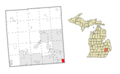
Map showing Hazel Park's location in Oakland County.
-
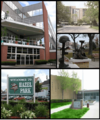
A montage of images from Hazel Park, including the racetrack and high school.
See also
 In Spanish: Hazel Park para niños
