Oakland County, Michigan facts for kids
Quick facts for kids
Oakland County, Michigan
|
|||||
|---|---|---|---|---|---|
| County of Oakland | |||||
|
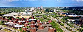
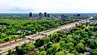
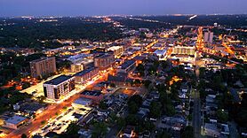
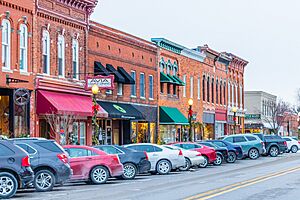
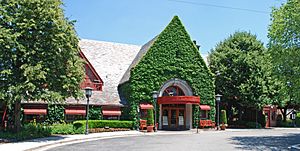
Top-to-bottom, left-to-right: Troy's skyline, Southfield's skyline, Rackham Fountain (at the Detroit Zoo), National Shrine of the Little Flower Basilica (Royal Oak), Downtown Pontiac, Downtown Royal Oak (downtown Detroit on the horizon)
|
|||||
|
|||||
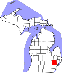
Location within the state of Michigan
|
|||||
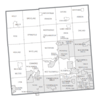
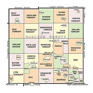
Cities and Townships in the county
|
|||||
| Country | United States | ||||
| State | Michigan | ||||
| Metro | Metro Detroit | ||||
| Incorporated | 1819 (created) 1820 (organized) |
||||
| County seat | Pontiac (Legislative and Judicial) Waterford (Executive) |
||||
| Largest city | |||||
| Area | |||||
| • Total | 907 sq mi (2,350 km2) | ||||
| • Land | 868 sq mi (2,250 km2) | ||||
| • Water | 40 sq mi (100 km2) | ||||
| Population
(2020)
|
|||||
| • Total | 1,274,395 | ||||
| • Estimate
(2023)
|
1,270,426 |
||||
| • Density | 1,405.1/sq mi (542.50/km2) | ||||
| GDP | |||||
| • Total | $124.285 billion (2022) | ||||
| Time zone | UTC−5 (Eastern Time Zone) | ||||
| • Summer (DST) | UTC−4 (Eastern Daylight Time) | ||||
| Area codes | 248 and 947 | ||||
Oakland County is a county in the state of Michigan. It's a big part of the Detroit metropolitan area, home to many of Detroit's northern suburbs. The main government office, called the county seat, is in Pontiac. The largest city in the county is Troy.
In 2020, about 1.27 million people lived here. This makes it the second most populated county in Michigan. It's also the most populated county in the United States without a single city of 100,000 residents. Oakland County was created in 1819 and officially started in 1820. It has 62 cities, villages, and townships. In 2010, Oakland County was one of the ten richest counties in the U.S. with over a million people. It is also home to Oakland University, a large public university.
Contents
History of Oakland County
Oakland County was created by Governor Lewis Cass in 1819. It was formed from Macomb County in 1820. As more people moved in, parts of Oakland County were used to create other counties. This happened over 16 years, leading to the formation of many new counties around it.
Important roads like Woodward Avenue and the Detroit and Pontiac Railroad helped bring settlers in the 1840s. By 1840, Oakland County had over fifty lumber mills. These mills processed wood from the area. Pontiac, located on the Clinton River, was the first town and became the county seat.
After the Civil War, Oakland County was mostly a farming area with small villages. By the late 1800s, Pontiac had three train lines. This helped the city attract factories that made carriages and wagons. In the late 1890s, streetcars connected Pontiac to Detroit.
Around this time, southern Oakland County became a suburb of Detroit. Many people moved from Oakland County farms to Detroit for factory jobs. By 1910, wealthy people from Detroit built summer homes in what is now Bloomfield Hills. The car industry grew in Pontiac in the early 1900s. The Oakland Motor Car Company started in 1907 and became part of General Motors.
In the 1950s, Oakland County's population grew a lot. People from Detroit started moving to the suburbs. While nearby Macomb County had more factory workers, Oakland County attracted more professionals like doctors and lawyers. For a while, Oakland County was the fourth wealthiest county in the U.S. Its wealth has changed a bit since then. The average home price in Oakland County is higher than the national average. The county is also home to large shopping malls like Oakland Mall and Twelve Oaks Mall.
Geography of Oakland County
Oakland County covers about 907 square miles (2,350 square kilometers). About 868 square miles (2,250 square kilometers) is land, and 40 square miles (100 square kilometers) is water.
The county was first divided into 25 townships. Each township is roughly 6 miles (9.7 km) by 6 miles. This design came from early U.S. land laws. Section 16 in each township was set aside to help pay for public schools. Even today, many schools in Oakland County are in these areas.
Wayne County, where Detroit is located, is south of Oakland County. 8 Mile Road is the border between these counties. This road was used as a "baseline" when Michigan was first surveyed. Over time, as more people moved to the suburbs, 8 Mile Road became known as a dividing line.
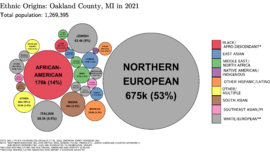
Since the late 1900s, the suburbs have become much more diverse. Many middle-class African Americans have moved from Detroit to nearby suburbs. For example, Southfield's population is now about 75% Black. Other cities like Farmington, Novi, and Troy also have many different ethnic groups. These include people of Asian, Arab, and other backgrounds.
Neighboring Counties
- Lapeer County (northeast)
- Genesee County (northwest)
- Macomb County (east)
- Wayne County (southeast)
- Washtenaw County (southwest)
- Livingston County (west)
Population and People
| Historical population | |||
|---|---|---|---|
| Census | Pop. | %± | |
| 1820 | 330 | — | |
| 1830 | 4,911 | 1,388.2% | |
| 1840 | 23,646 | 381.5% | |
| 1850 | 31,270 | 32.2% | |
| 1860 | 38,261 | 22.4% | |
| 1870 | 40,867 | 6.8% | |
| 1880 | 41,537 | 1.6% | |
| 1890 | 41,245 | −0.7% | |
| 1900 | 44,792 | 8.6% | |
| 1910 | 49,576 | 10.7% | |
| 1920 | 90,050 | 81.6% | |
| 1930 | 211,251 | 134.6% | |
| 1940 | 254,068 | 20.3% | |
| 1950 | 396,001 | 55.9% | |
| 1960 | 690,259 | 74.3% | |
| 1970 | 907,871 | 31.5% | |
| 1980 | 1,011,793 | 11.4% | |
| 1990 | 1,083,592 | 7.1% | |
| 2000 | 1,194,156 | 10.2% | |
| 2010 | 1,202,362 | 0.7% | |
| 2020 | 1,274,395 | 6.0% | |
| 2023 (est.) | 1,270,426 | 5.7% | |
| U.S. Decennial Census 1790–1960 1900–1990 1990–2000 2010–2019 |
|||
In 2020, Oakland County had about 1,274,402 people living in 524,762 homes. On average, there were 2.4 people per home. About 70% of the people were White, 13.9% were Black or African American, and 8.8% were Asian. About 5% of the population was Hispanic or Latino. Roughly 13.1% of residents were born in other countries.
About 20% of homes had children under 18. About 19.1% of homes had someone living alone who was 65 or older. Just over half (50.6%) of the residents were female. Nearly half (49.5%) of adults aged 25 and older had at least a bachelor's degree.
In 2020, the average household income in Oakland County was $92,620. This makes Oakland County the wealthiest county in Michigan. About 71.9% of homes were owned by the people living in them. About 8.72% of the population lived below the poverty line.
Transportation in Oakland County
Airports
- Oakland County International Airport (PTK) in Waterford Township is for private and charter flights.
- Oakland/Troy Airport (VLL) in Troy is also for private and charter flights.
Other airports nearby:
- Detroit Metropolitan Wayne County Airport (DTW) is a major airport in Wayne County.
- Bishop International Airport (FNT) is in Genesee County.
Main Highways
 I-75 is a major north-south highway. It connects Flint, Pontiac, Troy, and Detroit.
 I-96 runs northwest-southeast through the county. It ends in downtown Detroit.
 I-275 goes north-south and helps drivers bypass Detroit's western suburbs.
 I-696 goes east-west through Detroit's northern suburbs. I-275 and I-696 together form a semicircle around Detroit.
 US 24 is also known as Telegraph Road. It's a main north-south road that goes through Oakland County to Pontiac.
 M-1 is Woodward Avenue. It starts in Pontiac and goes south into Detroit. The Detroit Zoo is on M-1. It's also famous for the Woodward Dream Cruise, a huge classic car event in August.
 M-5 provides quick access to I-96, I-275, and I-696.
 M-10 is the John C. Lodge Freeway. It runs near I-75 from Southfield to Detroit.
 M-59 is a major east-west road. It goes through Pontiac and connects to other counties.
 M-102, also known as 8 Mile Road, forms the border between Oakland and Wayne counties. It's well-known from the movie 8 Mile.
Train Travel
Amtrak's Wolverine train serves Oakland County three times a day. It stops in Pontiac, Troy, and Royal Oak. From there, it continues to Detroit and west to Chicago.
Mile Roads
In the Detroit area, roads are often named by "mile roads." These are major east-west streets that are one mile apart. As you go north from the city center, the numbers increase. In Oakland County, these roads often have local names too, like Maple Road for 15 Mile Road.
Biking in Oakland County
Most roads in Oakland County are not very bike-friendly. However, some inner suburbs have better conditions for cycling. This is because their streets are laid out in a grid.
The Road Commission for Oakland County generally does not build roads with bikes in mind. Because of this, some communities have created "safety paths" for bikes. These paths are often next to roads and may not be as safe as dedicated bike lanes.
Currently, no communities in Oakland County are officially recognized as "Bicycle Friendly Communities." Only the city of Ferndale has a good network of bike lanes and shared roads for cyclists.
Education in Oakland County
Oakland County has many schools. The public school system (K-12) is overseen by Oakland Schools. The county also has well-known private schools, such as The Roeper School and Cranbrook.
Colleges and Universities
- Oakland University
- Oakland Community College
- Lawrence Technological University
- Baker College of Royal Oak
- Rochester Christian University
- Walsh College
- Saint Mary's College of Madonna University
- Cranbrook College of Art
K-12 School Districts
- Almont Community Schools
- Avondale School District
- Berkley School District
- Birmingham City School District
- Bloomfield Hills School District
- Brandon School District
- Clarenceville School District
- Clarkston Community School District
- Clawson Public Schools
- Farmington Public Schools
- Fenton Area Public Schools
- Ferndale Public Schools
- Goodrich Area Schools
- Grand Blanc Community Schools
- Hazel Park City School District
- Holly Area School District
- Huron Valley Schools
- Lake Orion Community Schools
- Lamphere Public Schools
- Madison Public Schools
- Northville Public Schools
- Novi Community School District
- Oak Park City School District
- Oxford Area Community Schools
- Pontiac City School District
- Rochester Community Schools
- Romeo Community Schools
- Royal Oak City School District
- South Lyon Community Schools
- Southfield Public School District
- Troy School District
- Walled Lake Consolidated Schools
- Warren Consolidated Schools
- Waterford School District
- West Bloomfield School District
Sports in Oakland County
| Club | League | Venue | Established | Championships |
|---|---|---|---|---|
| Oakland County FC | Premier League of America, Soccer | Clawson Park Stadium | 2015 |
The Detroit Lions (NFL football team) used to play their home games at the Pontiac Silverdome in Pontiac from 1975 to 2001. They then moved to Ford Field in Detroit. The Detroit Pistons (NBA basketball team) also played at the Silverdome from 1978 to 1988. The Silverdome hosted Super Bowl XVI in 1982, where the San Francisco 49ers won. The Pontiac Silverdome was torn down in 2017.
From 1988 to 2017, the Detroit Pistons played at The Palace of Auburn Hills in Auburn Hills. They then moved to Little Caesars Arena in Detroit. The Palace of Auburn Hills was torn down in 2020.
Communities in Oakland County
Cities
- Auburn Hills
- Berkley
- Birmingham
- Bloomfield Hills
- Clarkston
- Clawson
- Farmington
- Farmington Hills
- Fenton (mostly in Genesee County)
- Ferndale
- Hazel Park
- Huntington Woods
- Keego Harbor
- Lake Angelus
- Lathrup Village
- Madison Heights
- Northville (partially in Wayne County)
- Novi
- Oak Park
- Orchard Lake Village
- Pleasant Ridge
- Pontiac (county seat)
- Rochester
- Rochester Hills
- Royal Oak
- South Lyon
- Southfield
- Sylvan Lake
- Troy
- Walled Lake
- Wixom
Villages
- Beverly Hills
- Bingham Farms
- Franklin
- Holly
- Lake Orion
- Leonard
- Milford
- Ortonville
- Oxford
- Wolverine Lake
Charter Townships
- Bloomfield Charter Township
- Brandon Charter Township
- Commerce Charter Township
- Highland Charter Township
- Independence Charter Township
- Lyon Charter Township
- Milford Charter Township
- Oakland Charter Township
- Orion Charter Township
- Oxford Charter Township
- Royal Oak Charter Township
- Springfield Charter Township
- Waterford Charter Township
- West Bloomfield Charter Township
- White Lake Charter Township
Civil Townships
- Addison Township
- Groveland Township
- Holly Township
- Novi Township
- Rose Township
- Southfield Township
Unincorporated Communities
- Andersonville
- Austin Corners
- Brandon Gardens
- Campbells Corner
- Charing Cross
- Clintonville
- Clyde
- Commerce
- Davisburg
- Drayton Plains
- East Highland
- Elizabeth Lake
- Five Points
- Four Towns
- Gingellville
- Glengary
- Goodison
- Groveland Corners
- Hickory Ridge
- Highland
- Huron Heights
- Jossman Acres
- Kensington
- Lake Orion Heights
- Lakeville
- New Hudson
- Newark
- Oak Grove
- Oakley Park
- Oakwood
- Oxbow
- Perry Lake Heights
- Rose Center
- Rose Corners
- Rudds Mill
- Seven Harbors
- Springfield
- Thomas
- Union Lake
- Walters
- Waterford Village
- Waterstone
- West Highland
- Westacres
- White Lake
Rivers and Lakes in Oakland County
Oakland County is home to 387 lakes. Four main rivers also flow through the county:
The starting points (headwaters) of all these rivers are located in Oakland County.
See also
 In Spanish: Condado de Oakland para niños
 | Bessie Coleman |
 | Spann Watson |
 | Jill E. Brown |
 | Sherman W. White |


