Clinton River (Michigan) facts for kids
Quick facts for kids Clinton River |
|
|---|---|

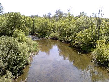
The Clinton River in Macomb County
|
|

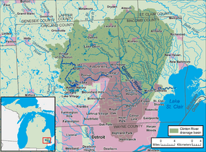
A map of the Clinton River and its watershed
|
|
| Country | United States |
| State | Michigan |
| Counties | Oakland, Macomb |
| Physical characteristics | |
| River mouth | Lake St. Clair 42°35′24.76″N 82°49′17.17″W / 42.5902111°N 82.8214361°W |
| Length | 83 miles (134 km) |
| Basin features | |
| Basin size | 760 square miles (2,000 km2) |
The Clinton River is a river in southeastern Michigan in the United States. It was named to honor DeWitt Clinton, who was the governor of New York from 1817 to 1823.
Contents
About the Clinton River
The main part of the Clinton River starts in wet areas and from cold water streams in places like Independence, Brandon, and Springfield Townships. Several dams create small lakes west of Pontiac, with Crystal Lake being the last one.
The river actually flows underground through downtown Pontiac. It then comes out again to the east of the city. The north and middle parts of the river begin in northern Macomb County. They join the main river in Clinton Township. This township was named after the river in 1824.
Where the River Flows
The main river flows for about 83 miles (134 km) from where it starts. It ends up flowing into Lake St. Clair in Harrison Township.
The area of land that drains into the Clinton River is called its watershed. This watershed covers about 760 square miles (1,968 sq km). It includes most of Macomb County and a large part of Oakland County. It also covers small pieces of Lapeer and St. Clair counties.
More than 1.4 million people live in this watershed. These people live in over 60 different towns and cities. Only the parts of the river downstream from the city of Mount Clemens are usually deep enough for boats to travel on.
Keeping the River Clean
In 1972, the lower part of the Clinton River was identified as an "Area of Concern." This was part of the Great Lakes Water Quality Agreement. It meant there was a lot of pollution in that section of the river.
By 1995, this special designation was expanded. It then included the entire river watershed and the nearby parts of Lake St. Clair. This was done to help focus efforts on cleaning up the river and protecting its environment.
A Big Canal Project
The Clinton-Kalamazoo Canal was a project that didn't quite work out. The idea was to build a waterway connecting Lake St. Clair with Lake Michigan. It was planned to be 216 miles (348 km) long. However, the project was stopped after only 13 miles (21 km) were finished.

The River's History
Long ago, in the late 1600s, French explorers called the river the Nottawasippee. This was an Ojibwe word that meant "like rattlesnakes." This name was also used by the local Anishinaabe people for the Huron people.
Changing Names
Later, British fur traders called it the Huron River of St. Clair. In 1784, the first American settler in the area, William Tucker, built his home along the river. He referred to it as "the River Huron." His home was about 3 miles (5 km) upstream from where the river meets Lake St. Clair.
The river received its current name, the Clinton River, on July 17, 1824. The Michigan Territorial Council made this change. They wanted to avoid confusion with another river, the Huron River of Lake Erie. That river also starts in Oakland County's Springfield Township.
Protecting the River
The Huron-Clinton Metroparks system helps protect land along the river. They turn these areas into public parks for everyone to enjoy. For example, Wolcott Mill Metropark is located on the north branch of the Clinton River.
 | John T. Biggers |
 | Thomas Blackshear |
 | Mark Bradford |
 | Beverly Buchanan |

