St. Clair County, Michigan facts for kids
Quick facts for kids
St. Clair County
|
||
|---|---|---|

|
||
|
||

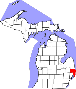
Location within the U.S. state of Michigan
|
||
 Michigan's location within the U.S. |
||
| Country | ||
| State | ||
| Founded | March 28, 1820 (created) 1821 (organized) |
|
| Named for | St. Clare of Assisi | |
| Seat | Port Huron | |
| Largest city | Port Huron | |
| Area | ||
| • Total | 837 sq mi (2,170 km2) | |
| • Land | 721 sq mi (1,870 km2) | |
| • Water | 115 sq mi (300 km2) 14%% | |
| Population
(2020)
|
||
| • Total | 160,383 |
|
| • Density | 190/sq mi (70/km2) | |
| Time zone | UTC−5 (Eastern) | |
| • Summer (DST) | UTC−4 (EDT) | |
| Area code | 810 | |
| Congressional district | 9th | |
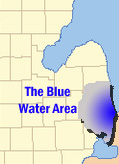
St. Clair County is a county located in the state of Michigan, USA. It sits along the western bank of the St. Clair River. As of the 2020 census, about 160,383 people lived there. This makes it the 13th most populated county in Michigan. The main city and county seat is Port Huron. Port Huron is found where the St. Clair River meets Lake Huron. The county was officially created in 1820 and its government started in 1821. It is located northeast of Detroit. This area is often called "The Thumb" because of its shape on the Michigan map. It is also known as the "Blue Water Area."
Contents
Why is it Called St. Clair County?
The name St. Clair comes from a French explorer named René-Robert Cavelier, Sieur de La Salle. In 1679, he explored this area. On August 12, he named the lake Lac Sainte-Claire. This was because it was the special feast day of Saint Clare of Assisi. English mapmakers later used this French name. By 1755, maps showed the spelling as St. Clair. This spelling became official in 1924. The county was named after the nearby Lake St. Clair and St. Clair River.
Some people mistakenly think the county was named after Arthur St. Clair. He was a general in the American Revolutionary War. However, the name was used long before he became famous. Others sometimes think it was named after Patrick Sinclair. He was a British officer who built Fort Sinclair in the area around 1764. But the name was already in use before he was active there.
Exploring St. Clair County's Geography
St. Clair County covers about 837 square miles. About 721 square miles are land, and 115 square miles (14%) are water. St. Clair County is one of five counties that form "the Thumb" of Michigan. This "Thumb" is a peninsula that sticks out into Lake Huron. The county's economy is closely linked to its neighbors. These include Metro Detroit and Sanilac County in Michigan. It also connects with Lambton County across the river in Ontario, Canada. St. Clair County is the main part of "The Blue Water Area."
Neighboring Counties
- Sanilac (north)
- Lapeer (west)
- Macomb (south)
- Lambton, Ontario (east)
Main Roads and Highways
 I-69 comes from Lansing and Flint. It ends at the Blue Water Bridge in Port Huron.
 I-94 enters from the southwest, passing through the Detroit area. It also ends at the Blue Water Bridge in Port Huron.
 BL I-69
 BL I-94
 M-19
M-19 M-25 follows the Lake Huron shoreline. It starts in Bay City and ends near Port Huron.
 M-29
M-29- M-136
 M-154 serves Harsens Island in Lake St. Clair.
Population and People of St. Clair County
| Historical population | |||
|---|---|---|---|
| Census | Pop. | %± | |
| 1830 | 1,114 | — | |
| 1840 | 4,606 | 313.5% | |
| 1850 | 10,420 | 126.2% | |
| 1860 | 26,604 | 155.3% | |
| 1870 | 36,661 | 37.8% | |
| 1880 | 46,197 | 26.0% | |
| 1890 | 52,105 | 12.8% | |
| 1900 | 55,228 | 6.0% | |
| 1910 | 52,341 | −5.2% | |
| 1920 | 58,009 | 10.8% | |
| 1930 | 67,563 | 16.5% | |
| 1940 | 76,222 | 12.8% | |
| 1950 | 91,599 | 20.2% | |
| 1960 | 107,201 | 17.0% | |
| 1970 | 120,175 | 12.1% | |
| 1980 | 138,802 | 15.5% | |
| 1990 | 145,607 | 4.9% | |
| 2000 | 164,235 | 12.8% | |
| 2010 | 163,040 | −0.7% | |
| 2020 | 160,383 | −1.6% | |
| 2023 (est.) | 159,874 | −1.9% | |
| U.S. Decennial Census 1790–1960 1900–1990 1990–2000 2010–2019 |
|||
The 2010 census showed that St. Clair County had 163,040 people. This was a small decrease from the year 2000. In 2010, there were about 63,841 households. A household is a group of people living together. About 31.3% of these households had children under 18 living with them. The average household had 2.52 people.
The population was spread out by age. About 23.7% of people were under 18 years old. About 14.5% were 65 years or older. The average age in the county was 41 years. Most people in the county were White (93.9%). Other groups included Black or African American (2.4%) and Asian (0.5%). About 2.9% of the population was Hispanic or Latino.
Parks and Recreation
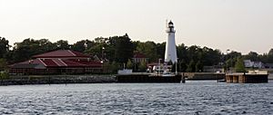
St. Clair County has five county parks for everyone to enjoy. These include Columbus County Park, Fort Gratiot County Park, and Goodells County Park. The Fort Gratiot Light station is also a county park. Woodsong County Park is another great spot. The county also manages the Wadhams to Avoca Trail. They work with local towns to build the Bridge to Bay Trail. These trails are perfect for walking and biking.
Cities, Towns, and Communities

St. Clair County is home to many different communities. These include cities, villages, and townships.
Cities
- Algonac
- Marine City
- Marysville
- Memphis (partially)
- Port Huron (the county seat)
- Richmond (partially)
- St. Clair
- Yale
Villages
Charter Townships
Civil Townships
Census-Designated Place
Other Unincorporated Communities
- Abbottsford
- Adair
- Allenton
- Anchorville
- Atkins
- Avoca
- Avalon Beach
- Bedore
- Belle River
- Berville
- Blaine
- Broadbridge Station
- Brockway
- Casco
- Cherry Beach
- Clays Landing
- Columbus
- Copeland Corner
- Fair Haven
- Fargo
- Forster
- Gardendale
- Grande Pointe
- Goodells
- Hawthorne
- Jeddo
- Kimball
- Keewahdin
- Lakeport
- Lambs
- Lesterville
- Maple Leaf
- Martindale Beach
- Miller
- Muirs
- Muttonville
- North Lakeport
- North Street
- Perch Point
- Peters
- Pointe aux Tremble
- Purssia (Dissolved in 2021)
- Rattle Run
- Riley Center
- Riverside
- Roberts Landing
- Ruby
- Sans Souci
- Smiths Creek
- Snyderville
- South Park
- Sparlingville
- Starville
- Tappan
- Thornton
- Wadhams
- Wales
- West Tappan
See also
 In Spanish: Condado de St. Clair (Míchigan) para niños
 | Shirley Ann Jackson |
 | Garett Morgan |
 | J. Ernest Wilkins Jr. |
 | Elijah McCoy |


