Clyde Township, St. Clair County, Michigan facts for kids
Quick facts for kids
Clyde Township, Michigan
|
|
|---|---|

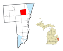
Location within St. Clair County
|
|
| Country | United States |
| State | Michigan |
| County | St. Clair |
| Organized | 1836 |
| Area | |
| • Total | 36.0 sq mi (93.2 km2) |
| • Land | 35.9 sq mi (92.9 km2) |
| • Water | 0.1 sq mi (0.3 km2) |
| Elevation | 696 ft (212 m) |
| Population
(2020)
|
|
| • Total | 5,523 |
| • Density | 153.42/sq mi (59.26/km2) |
| Time zone | UTC-5 (Eastern (EST)) |
| • Summer (DST) | UTC-4 (EDT) |
| ZIP code(s) |
48049
|
| Area code(s) | 810 |
| FIPS code | 26-16760 |
| GNIS feature ID | 1626104 |
Clyde Township is a special kind of local government area called a civil township. It is located in St. Clair County in the state of Michigan, United States. In 2020, about 5,523 people lived here.
Contents
History of Clyde Township
How Clyde Township Got Its Name
Clyde Township is named after the River Clyde in Scotland. A man named Robert Smart, who was from Scotland, built a mill on the Black River in 1825. He named the place "Clyde Mills." This was a tribute to the river where he grew up as a boy.
When Clyde Township Was Formed
Clyde Township was officially organized in March 1836. It took its name from the "Clyde Mills" settlement. When it was first created, Clyde Township was much larger. It covered an area that is now 20 different townships!
Changes Over Time
In 1855, a new township called Kimball Township was formed. When this happened, the original "Clyde Mills" settlement became part of Kimball Township. That settlement is now known as Wadhams.
Communities in Clyde Township
Clyde Township has several smaller areas called unincorporated communities. These are places where people live but they don't have their own separate local government like a city or village.
Abbottsford
Abbottsford is a community located on the western edge of Clyde Township. It borders Kenockee Township.
Atkins
Atkins is found in the north-central part of the township. It is on Wildcat Road. The first settlers here were Allen Atkins in 1837 and William Atkins in 1839. Atkins used to be a stop on the Pere Marquette Railway. It also had a post office for many years, from 1873 to 1935.
North Street
North Street is in the eastern part of Clyde Township. It is located on North Road, south of Carrigan Road. This community was also a station on the Pere Marquette Railway. It was named "North Street" because it was on North Road, which is now part of M-136. North Street had a post office in 1879, which reopened in 1884. The ZIP code for North Street, 48049, covers most of Clyde Township. You can also use "Clyde, Michigan" or "Ruby, Michigan" for this ZIP code.
Ruby
Ruby is in the west-central part of the township. It is located at the intersection of Brott and Abbottsford Roads. This community also had a post office. It operated from September 1854 until January 1907.
Geography of Clyde Township
Clyde Township covers a total area of about 36.0 square miles (93.2 square kilometers). Most of this area, about 35.9 square miles (92.9 square kilometers), is land. A small part, about 0.1 square miles (0.3 square kilometers), is water.
Wildlife in Clyde Township
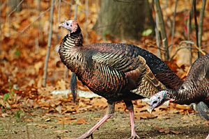
Clyde Township is home to various wildlife. For example, you can often spot wild turkeys. They like to live around the Black River Valley area.
See also
 In Spanish: Municipio de Clyde (condado de St. Clair) para niños
 | Selma Burke |
 | Pauline Powell Burns |
 | Frederick J. Brown |
 | Robert Blackburn |


