Kimball Township, Michigan facts for kids
Quick facts for kids
Kimball Township, Michigan
|
|
|---|---|

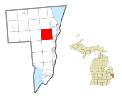
Location within St. Clair County
|
|
| Country | United States |
| State | Michigan |
| County | St. Clair |
| Organized | 1855 |
| Area | |
| • Total | 37.5 sq mi (97.2 km2) |
| • Land | 37.3 sq mi (96.5 km2) |
| • Water | 0.3 sq mi (0.7 km2) |
| Elevation | 636 ft (194 m) |
| Population
(2020)
|
|
| • Total | 9,609 |
| • Density | 256.2/sq mi (98.86/km2) |
| Time zone | UTC-5 (Eastern (EST)) |
| • Summer (DST) | UTC-4 (EDT) |
| ZIP code(s) |
48074
|
| Area code(s) | 810 |
| FIPS code | 26-43160 |
| GNIS feature ID | 1626559 |
Kimball Township is a cool place in St. Clair County, Michigan, USA. It's like a small town area with its own local government. In 2020, about 9,609 people called Kimball Township home.
Contents
Exploring Kimball Township's Communities
Kimball Township is home to several smaller, unique areas. These are called unincorporated communities. They don't have their own separate city governments but are part of the township.
Kimball: The Heart of the Township
The community of Kimball is located near the center of the township. It's found around Ditty and Dove Roads. People started buying land here as early as 1825. However, the first settlers didn't arrive until about 1840. Two important early settlers were Barzillai Wheeler and John S. Kimball. When the township was officially formed in 1855, it was named after John S. Kimball.
Kimball became a stop on the Port Huron and Northwestern Railway in 1882. It even had its own post office, first called "Kimbal" and then corrected to "Kimball." The post office closed in 1908.
Smiths Creek: A Historic Spot
Smiths Creek is located in the southwestern part of Kimball Township. It's named after Elisha Smith, who owned land there a long time ago. The community also gets its name from the Smiths Creek tributary of the Pine River.
A post office opened in Smiths Creek in 1861. It also became a train station on the Grand Trunk Railroad line in 1865. For a short time, from 1869 to 1871, Smiths Creek was even the county seat of St. Clair County! This means it was the main government center for the county. Today, the St. Clair County Sanitary Landfill is located here.
Smiths Creek is also famous for a story about Thomas Edison. It's said that he was asked to leave a train here because of his science experiments! The old train depot from Smiths Creek is now preserved at Greenfield Village, which is part of the Henry Ford museum. The ZIP code for all of Kimball Township is 48074, and it's based in Smiths Creek.
Sparlingville: A Planned Community
Sparlingville is on the west side of the township. It's located around Allen and Griswold Roads. George Sparling, a builder, started this community around 1923. Sparlingville was once its own officially recognized area. Today, the Kimball Township hall, fire hall, library, and Sparlingville Elementary School are all located in this community.
Thornton: On the Border
The community of Thornton, sometimes spelled Thorton, sits right on the border with Wales Township.
Wadhams: A River Town History
Wadhams is in the northeast corner of the township. It's found at Wadhams and Lapeer roads. In 1825, a man named Robert Smart built a mill on the Black River. He called the place "Clyde Mills," named after a river in Scotland. In 1827, Ralph Wadhams bought the mill.
A post office named Clyde Mills operated here for many years. Clyde Township was formed in 1836 and got its name from this settlement. Interestingly, when Kimball Township was created in 1855, the original Clyde Mills settlement became part of Kimball Township. This apparently made Ralph Wadhams quite disappointed! Wadhams had its own post office at different times. Today, Wadhams has seen new buildings and growth because it's close to Interstate 69 (I-69) and Old M-21.
West Tappan: Near the Tracks
West Tappan is located south of Wadhams and I-69. It's on Wadhams Road near the train tracks.
Kimball Township's Geography
Kimball Township covers a total area of about 37.5 square miles (97 km2). Most of this area, about 37.2 square miles (96 km2), is land. A small part, about 0.3 square miles (0.78 km2), is water.
Who Lives in Kimball Township?
In 2000, there were 8,628 people living in Kimball Township. About 3,120 households and 2,383 families called it home. The average household had about 2.74 people. The average family had about 3.09 people.
The population was spread out by age. About 26.5% of the people were under 18 years old. About 10.3% were 65 years or older. The average age of people in the township was 36 years old.
See also
 In Spanish: Municipio de Kimball (Míchigan) para niños
 | Calvin Brent |
 | Walter T. Bailey |
 | Martha Cassell Thompson |
 | Alberta Jeannette Cassell |


