Fort Gratiot Township, Michigan facts for kids
Quick facts for kids
Fort Gratiot Township, Michigan
|
|
|---|---|
|
Charter township
|
|
| Charter Township of Fort Gratiot | |

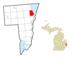
Location within St. Clair County
|
|
| Country | United States |
| State | Michigan |
| County | St. Clair |
| Established | 1866 |
| Area | |
| • Total | 16.1 sq mi (41.7 km2) |
| • Land | 16.1 sq mi (41.7 km2) |
| • Water | 0.0 sq mi (0.1 km2) |
| Elevation | 607 ft (185 m) |
| Population
(2020)
|
|
| • Total | 11,242 |
| • Density | 698.3/sq mi (269.6/km2) |
| Time zone | UTC-5 (Eastern (EST)) |
| • Summer (DST) | UTC-4 (EDT) |
| ZIP code(s) |
48059
|
| Area code(s) | 810 |
| FIPS code | 26-29760 |
| GNIS feature ID | 1626300 |
Fort Gratiot Township is a special kind of town area called a charter township in St. Clair County, Michigan. It's located in the U.S. state of Michigan. In 2020, about 11,242 people lived here.
The township is named after Fort Gratiot. This was an important American fort that existed in the area from 1814 to 1879.
| Top - 0-9 A B C D E F G H I J K L M N O P Q R S T U V W X Y Z |
History of Fort Gratiot
Fort Gratiot Township was officially created in 1867. It got its name from General Charles Gratiot. He was an engineer who helped design and plan the original fort.
Communities in Fort Gratiot
Fort Gratiot Township has a few smaller communities within its borders.
Gardendale
- Gardendale is an unincorporated community. This means it's a small area with people living there, but it doesn't have its own local government like a city or village. It's near the center of the township. Long ago, it was a stop on the Pere Marquette Railway. It even had its own post office for a while, from 1891 to 1906.
Keewahdin Beach
- Keewahdin or Keewahdin Beach was a popular resort area. It was built in 1914 by the Keewahdin Park Association. This resort was located right on the shores of Lake Huron. The name "Keewahdin" probably came from Kewadin, a famous leader of the Ojibwe people.
Port Huron
- The city of Port Huron is right next to Fort Gratiot Township. It's located to the southeast.
Geography of Fort Gratiot
Fort Gratiot Township covers about 16.1 square miles (41.7 square kilometers) of land. Only a tiny bit of its area is water.
The township is on the southwestern shore of Lake Huron. This area is often called the Thumb of Michigan. This "Thumb" region is part of a larger area known as the Flint/Tri-Cities. Fort Gratiot is a big shopping area for the "Blue Water Area," which is another part of the Thumb. You can find the Birchwood Mall and many large stores here.
Population and People
In 2000, there were about 10,691 people living in Fort Gratiot Township. There were 4,076 homes, with many families living together.
The population includes people of all ages. About 24.7% of the people were under 18 years old. About 14.3% were 65 years old or older. The average age in the township was 39 years old.
See also
 In Spanish: Municipio de Fort Gratiot para niños
 | Georgia Louise Harris Brown |
 | Julian Abele |
 | Norma Merrick Sklarek |
 | William Sidney Pittman |


