Harsens Island facts for kids

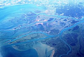
Aerial view of Harsens Island (center)
|
|
| Geography | |
|---|---|
| Location | Mouth of the St. Clair River at Lake St. Clair |
| Coordinates | 42°35′24″N 82°33′05″W / 42.59000°N 82.55139°W |
| Administration | |
| State | Michigan |
| County | St. Clair County |
| Township | Clay Township |
Harsens Island is a unique, marshy island located where the St. Clair River meets Lake St. Clair in Michigan, United States. It's a special place known for its natural beauty and interesting history. Politically, it's part of Clay Township in St. Clair County.
Contents
Island History
Naming the Island
The island is named after Jacob Harsen, who was the first European-American settler there. He moved from Albany, New York around 1779. In 1783, Jacob Harsen bought the island from the local Native American people. For a while, it was also called "Jacob Island." The post office on the island was named Sans Souci, but in 1960, its name was changed to "Harsens Island."
Disputed Ownership
For many years, both Great Britain and the United States argued over who owned Harsens Island. The 1783 Treaty of Paris, which ended the American Revolutionary War, described the border between the two countries. However, the description of the border around the St. Clair River was not very clear. Maps from that time didn't even show all the islands in the river's delta.
Because of this unclear description, the British claimed all the islands in the delta, including Harsens Island. Some people from the new United States who wanted to remain British subjects moved to these islands. The area was even managed by a British district in Canada. In 1809, British surveyors drew the border in a way that put all the delta islands under British control.
Setting the Boundary
The 1814 Treaty of Ghent, which ended the War of 1812, recognized that the 1783 treaty was confusing. To solve this, two commissioners, one from each country, were chosen to draw the exact border. They surveyed the area in 1819 and 1820. Their final decision in 1822 placed Harsens Island and Dickinson Island on the U.S. side of the border.
Later, around 1870, there was another dispute involving a Canadian captain named Hiram Little. His ship was seized by U.S. officials who said he was in U.S. waters. Captain Little argued he was in Canadian waters. After checking old maps and documents, it was found that Captain Little was correct. To avoid more problems, the U.S. officials moved the international border slightly east.
Today, the St. Clair River, from Russell Island to Lake St. Clair, is the official border. However, some people still debate who should truly own Harsens Island. The Walpole Island First Nation believes Harsens Island is unceded territory and rightfully belongs to them.
Island Life Today
Harsens Island is special because it's the only U.S. island in the St. Clair Flats that you can reach by car. You take a ferry to get there. It's also the only island with roads and a small community called Sans Souci. The island used to have a public school, which is now a restaurant. Visitors can also find shops, an art gallery, and a small airport. All the other U.S. islands in the area can only be reached by boat.
Island Geography
The St. Clair River Delta
The St. Clair River is a very important part of the Great Lakes system. It carries water from Lake Huron south into Lake St. Clair. From there, the water flows into the Detroit River and then into Lake Erie. The delta, where the river spreads out into many channels, formed about 6,000 years ago. This area has been a popular place for people to live for a very long time.
The St. Clair River forms the international border between the United States and Canada. This river is incredibly busy, carrying more freighter traffic than the Suez Canal and Panama Canal combined! Over 1 billion US gallons (3.8 million cubic meters) of fresh water flow down the St. Clair River every day, passing through its delta region, known as the St. Clair Flats.
Harsens Island is the main U.S. island in the Flats. On the Canadian side, you'll find even larger islands, including Walpole Island. These islands are controlled by the Walpole Island First Nation, which includes Ojibwa, Potawatomi, and Odawa peoples.
Wildlife and Nature
The St. Clair Flats is home to a wide variety of wildlife. You might see great blue herons, snapping turtles, watersnakes, muskrats, and mink. There are also whitetail deer, many types of ducks like pintail, canvasback, and mallard, along with Canada geese and red-winged blackbirds.
The area is also a popular spot for fishing. Anglers can catch yellow perch, large and small mouth bass, rock bass, carp, sunfish, pumpkinseed fish, bluegills, and silver bass. The State of Michigan owns about 75% of Harsens Island. They manage special areas there to protect waterfowl and other wildlife.
 | Victor J. Glover |
 | Yvonne Cagle |
 | Jeanette Epps |
 | Bernard A. Harris Jr. |


