
St. Clair River facts for kids

The St. Clair River (also known as French: Rivière Sainte-Claire in French) is an important river in central North America. It flows for about 40.5 miles (65 kilometers) from Lake Huron down into Lake St. Clair. This river forms a natural part of the border between two countries: the Canadian province of Ontario and the U.S. state of Michigan.
Contents
About the St. Clair River
The St. Clair River is like a busy highway for water. It connects two of the five Great Lakes: Lake Huron and Lake St. Clair. Water from Lake Huron flows through this river into Lake St. Clair, and then continues on to Lake Erie through the Detroit River.
Where is the St. Clair River?
This river is located in the middle of North America. It acts as a natural boundary, separating Canada from the United States. On the Canadian side, you'll find parts of Lambton County and Chatham-Kent in Ontario. On the U.S. side, it touches St. Clair County, Michigan and Macomb County, Michigan.
What's it like?
The St. Clair River is known for its clear waters and strong currents. It is a very important waterway for shipping. Large cargo ships, called freighters, use the river to carry goods like iron ore, coal, and grain between the Great Lakes. You can often see these big ships moving slowly along the river.
Bridges and Connections
One famous landmark on the St. Clair River is the Blue Water Bridge. This is actually two bridges that connect the city of Port Huron in Michigan, USA, with Sarnia in Ontario, Canada. It's a very busy crossing for cars and trucks between the two countries.
Wildlife and Nature
The river and its surrounding areas are home to many types of wildlife. Fish, birds, and other animals live in or near the water. The river's health is important for these creatures, and efforts are made to keep the water clean.
Images for kids
-
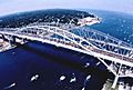
The start of the river looking into Lake Huron, showing the twin Blue Water Bridge.
-
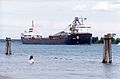
The Canadian freighter Algorail sailing down the St. Clair River.

.jpg)
See also
 In Spanish: Río St. Clair para niños
