Lapeer County, Michigan facts for kids
Quick facts for kids
Lapeer County
|
|
|---|---|

|
|

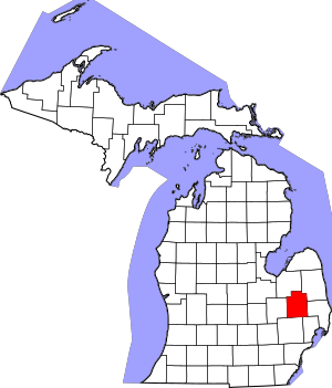
Location within the U.S. state of Michigan
|
|
 Michigan's location within the U.S. |
|
| Country | |
| State | |
| Founded | September 18, 1822 (created) February 2, 1835 (organized) |
| Seat | Lapeer |
| Largest city | Lapeer |
| Area | |
| • Total | 663 sq mi (1,720 km2) |
| • Land | 643 sq mi (1,670 km2) |
| • Water | 20 sq mi (50 km2) 3.0%% |
| Population
(2020)
|
|
| • Total | 88,619 |
| • Density | 137/sq mi (53/km2) |
| Time zone | UTC−5 (Eastern) |
| • Summer (DST) | UTC−4 (EDT) |
| Congressional district | 9th |
Lapeer County (pronounced lə-PEER) is a county in the state of Michigan, USA. In 2020, about 88,619 people lived here. The main city and county seat is Lapeer.
The county was first set up on September 18, 1822. It officially became a county on February 2, 1835. Its name comes from the French words la pierre, which means "the stone." Lapeer County is found north of Detroit and east of Flint.
History of Lapeer County
Lapeer County was once part of New France, starting in 1534. This area was known as the "Pays d'en Haut," or "upper countries." It was part of the Colony of Canada from 1712.
In 1763, England took control of all French lands in North America east of the Mississippi River. This happened after England won the Seven Years' War. The area then became part of the Province of Quebec. Both France and England traded with the First Nations (Native American tribes) in this area. They built forts for trading furs and to help settle disagreements.
From British Rule to American Territory
After the American Revolution, Great Britain gave parts of Quebec to the new United States of America. On July 13, 1787, the U.S. Congress created the Northwest Territory. This large area included what is now Lapeer County.
The area that is now Lapeer County was once part of a very large Wayne County. This original Wayne County was created on August 11, 1796. It covered all of Michigan's lower peninsula, parts of Ohio and Indiana, and even parts of Wisconsin and Illinois. As more people moved into the area, new counties were formed.
On May 7, 1800, Lapeer County became part of the Territory of Indiana. Later, the Territory of Michigan was formed. In 1807, local Native American tribes, including the Ottawa, Ojibwa (Chippewa), Wyandot, and Potawatomi, gave up their land in Southeast Michigan to the United States. This was part of the Treaty of Detroit.
Forming Lapeer County
In January 1820, Oakland County was formed. On September 18, 1822, Governor Lewis Cass set the borders for Lapeer County. However, it remained part of Oakland County until it was officially organized. Lapeer County officially became its own county on February 2, 1835. The first elections for county leaders happened in 1837, with 520 people voting.
The first European-American settler in Lapeer was Alvin N. Hart. He was born in Cornwall, Connecticut, in 1804. He came to Lapeer in 1831. He planned out the Village of Lapeer on November 8, 1833. Alvin Hart later became a state senator in 1843. He helped move the state capital from Detroit to Lansing.
On March 9, 1843, some townships were moved from western Lapeer County to Genesee County. These included Forest, Richfield, Davison, and Atlas townships.
Lumber and Farming
From the 1830s until 1870, the main business in Lapeer County was lumber. There was a high demand for wood as new towns were built across the Midwest. Clearing the forests also helped attract farmers to settle in the county. After 1870, Lapeer's economy mostly changed to farming.
On October 26, 2010, Lapeer County became a founding member of the Karegnondi Water Authority.
Historical Markers in Lapeer County
There are fifteen historical markers around Lapeer County. These markers point out interesting places and buildings:
- Columbiaville Depot
- Currier House (Almont)
- Dryden Depot
- General Squier Memorial Park (Dryden Township)
- Grand Trunk Western Railroad Depot / Imlay City
- Grettenberger Field (Imlay City)
- Henry Stephens Memorial Library (Almont)
- Ladies Library Hall (Dryden)
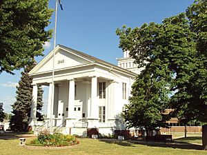
- Lapeer County (at Lapeer County Courthouse)
- Lapeer Public Library
- Pioneer Bank (North Branch)
- St. Patrick's Church (Clifford)
- Tuttle House (Lapeer)
- United Methodist Church (Columbiaville)
- William Peter Mansion (Columbiaville)
Geography

Lapeer County covers about 663 square miles. About 643 square miles are land, and 20 square miles (3.0%) are water. Lapeer County looks a lot like Oakland County, but it has more open, rural areas.
Lapeer is one of the five counties that make up "The Thumb" region of Michigan. This area looks like a thumb sticking out into Lake Huron.
The Flint River starts in Columbiaville. It flows through the county, including the city of Lapeer, and then into Genesee County.
Major Roads
 I-69 runs east and west through the county.
 M-24 runs north and south through the western part of the county, including the city of Lapeer.
 M-53 runs north and south through the eastern part of the county, including Imlay City.
 M-90 runs east and west through the county, including the city of North Branch.
Neighboring Counties
Lapeer County shares borders with these counties:
- Sanilac County (to the northeast)
- Tuscola County (to the northwest)
- St. Clair County (to the east)
- Genesee County (to the west)
- Macomb County (to the southeast)
- Oakland County (to the southwest)
Population Information
| Historical population | |||
|---|---|---|---|
| Census | Pop. | %± | |
| 1840 | 4,265 | — | |
| 1850 | 7,029 | 64.8% | |
| 1860 | 14,754 | 109.9% | |
| 1870 | 21,345 | 44.7% | |
| 1880 | 30,138 | 41.2% | |
| 1890 | 29,213 | −3.1% | |
| 1900 | 27,641 | −5.4% | |
| 1910 | 26,033 | −5.8% | |
| 1920 | 25,782 | −1.0% | |
| 1930 | 28,348 | 10.0% | |
| 1940 | 32,116 | 13.3% | |
| 1950 | 35,794 | 11.5% | |
| 1960 | 41,926 | 17.1% | |
| 1970 | 52,317 | 24.8% | |
| 1980 | 70,038 | 33.9% | |
| 1990 | 74,768 | 6.8% | |
| 2000 | 87,904 | 17.6% | |
| 2010 | 88,319 | 0.5% | |
| 2020 | 88,619 | 0.3% | |
| 2023 (est.) | 88,977 | 0.7% | |
| U.S. Decennial Census 1790-1960 1900-1990 1990-2000 2010-2018 |
|||
In 2010, there were 88,319 people living in Lapeer County. Most residents (95.5%) were White. About 1.0% were Black or African American, and 0.5% were Native American. About 4.1% of the population identified as Hispanic or Latino.
Many people in Lapeer County have German (23.9%), English (10.9%), or Irish (10.4%) backgrounds. Most people in the county speak English.
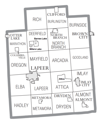
Communities
Cities
- Brown City (mostly in Sanilac County)
- Imlay City
- Lapeer (county seat)
Villages
- Almont
- Clifford
- Columbiaville
- Dryden
- Metamora
- North Branch
- Otter Lake (partly in Genesee County)
Civil Townships
- Almont Township
- Arcadia Township
- Attica Township
- Burlington Township
- Burnside Township
- Deerfield Township
- Dryden Township
- Elba Township
- Goodland Township
- Hadley Township
- Imlay Township
- Lapeer Township
- Marathon Township
- Mayfield Township
- Metamora Township
- North Branch Township
- Oregon Township
- Rich Township
Census-Designated Places
- Attica
- Barnes Lake
- Barnes Lake–Millers Lake (former)
- Millers Lake
Other Small Communities
See also
 In Spanish: Condado de Lapeer para niños
 | Emma Amos |
 | Edward Mitchell Bannister |
 | Larry D. Alexander |
 | Ernie Barnes |

