Flint River (Michigan) facts for kids
Quick facts for kids Flint River |
|
|---|---|

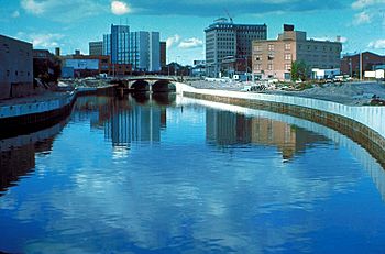
The Flint River in Flint, Michigan.
|
|

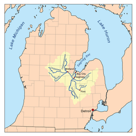
Map of the Saginaw River watershed showing the Flint River as one of its major tributaries
|
|
| Physical characteristics | |
| Main source | Lapeer County |
| River mouth | Shiawassee River Shiawassee National Wildlife Refuge 43°22′43″N 83°58′59″W / 43.37861°N 83.98306°W |
| Length | 78 mi (126 km) |
| Basin features | |
| River system | Saginaw River |
The Flint River is a river about 78.3-mile-long (126.0 km) in Michigan, United States. It flows through the central part of the state. The river starts in Lapeer County. It then travels through Genesee and Saginaw counties.
Several cities are located along the river. These include Lapeer, Flint, Flushing, and Montrose.
Contents
What's in a Name?
The name "Flint River" comes from the Ojibwe language. The Ojibwe people called it Biiwaanagoonh-ziibi. This means "Flinty River." Long ago, there was an Indian Reservation nearby. It was called Pewonigowink, which meant "By the Flinty River."
Where Does the River Flow?
The Flint River collects water from a large area. This area covers about 1,332 square miles (3,450 km2) of Michigan. It includes parts of Lapeer, Genesee, Shiawassee, Saginaw, Oakland, Tuscola, and Sanilac counties.
The river begins in Lapeer County near Columbiaville. Here, the South Branch and North Branch of the river join together. Many smaller streams add water to the Flint River. These include Kearsley Creek, Thread Creek, Swartz Creek, and Misteguay Creek.
The river flows southwest past the city of Flint. Then, it turns north near Flushing. Finally, it flows into the Shiawassee River. This happens in the Shiawassee National Wildlife Refuge near Saginaw. Other rivers like the Bad River and Cass River also join the Shiawassee. The Shiawassee River then meets the Tittabawassee River. Together, they form the Saginaw River. The Saginaw River eventually flows into Saginaw Bay, which is part of Lake Huron.
Important River Features
The Flint River has several interesting features along its path. These include dams and recreational areas.
Holloway Reservoir
The river is held back by a dam in Richfield Township. This creates the Holloway Reservoir. It was built between 1953 and 1955. The reservoir was originally meant to supply water to Flint. It also helped move river water through the city faster. By 1967, Flint started getting its drinking water from Lake Huron. The reservoir then became a backup water source.
C.S. Mott Lake
Further downstream, the C.S. Mott Dam forms C.S. Mott Lake. This dam was finished in 1972. The lake was created for fun activities like boating and fishing. Popular places along the lake include Crossroads Village, Stepping Stone Falls, and the Genesee Belle riverboat.
Utah Dam
The Utah Dam is mostly made of steel. It was built in 1928. Its original purpose was to stop factory waste from getting into the drinking water. Today, the dam's gates are open. This means it no longer blocks the river's flow.
Hamilton Dam
The Hamilton Dam is in downtown Flint, near the University of Michigan–Flint campus. It was built in 1920 and used to be a bridge for people to walk across. Now, it is in very bad condition. Because of its poor state, officials ordered that something be done by 2008.
Fabridam
Downstream from the Hamilton Dam is an inflatable dam. It is located west of the Grand Traverse Street Bridge. This dam, called the Fabridam, was completed in 1979. It was mainly for making the river look nice and for recreation. It was replaced in 2001 with a new dam.
Riverfront Landmarks
In the city of Flint, the river flows past many important places. It goes by former General Motors factories. One notable site is Chevrolet's first assembly plant. The river also runs through the University of Michigan–Flint campus and Riverbank Park. The historic Durant-Dort Carriage Company Office is also nearby. Further downstream, the river passes Kettering University and McLaren Hospital. The section of the river through downtown Flint has concrete sides.
Flint River Trail
A paved path called the Flint River Trail runs along the river. It stretches from downtown Flint to Carpenter Road and Johnson Elementary School. This trail connects to the Mott Lake Trailway. Together, these trails cover about 21.5 miles (34.6 km). Groups like the Friends of the Flint River Trail help maintain these paths.
River Life and Challenges
The Flint River has faced challenges with pollution over many years. However, efforts to clean it up have greatly improved the water quality since the 1950s and 1960s.
Fish and Wildlife
The river is home to various fish. You can find smallmouth bass, walleye, and some trout. There are fishing advisories for the river, similar to those for the Great Lakes.
Water Quality Concerns
The water in the Flint River has high levels of chlorides. These chlorides come partly from road salt used in winter. Chlorides do not directly harm fish or people. However, they can cause problems. They make lead and other metals in pipes wear away faster. This can lead to serious issues.
Flint Water Crisis
In April 2014, the city of Flint decided to change its water source. It had been buying water from Detroit. The city chose to switch to water directly from the Flint River. Soon after the switch, people started to notice problems. The water looked cloudy and smelled bad.
The city announced that the water had high levels of trihalomethanes. This is a chemical that forms when chlorine is used to treat water. It can be linked to health problems. In September 2015, a study showed a serious issue. The number of babies and children with high levels of lead in their blood had almost doubled. This happened after the city changed its water source.
Tests showed that the water leaving the treatment plant was lead-free. But by the time it reached homes, it could have high lead levels. This was because the Flint River water was more corrosive. It caused lead pipes to break down much faster than the water from Lake Huron. One study found it corroded lead pipes 19 times faster.
Cities and Villages Along the River
- Montrose, Michigan
- Flushing, Michigan
- Flint, Michigan
- Genesee, Michigan
- Columbiaville, Michigan
- Lapeer, Michigan
See also
 In Spanish: Río Flint (Míchigan) para niños
 | Audre Lorde |
 | John Berry Meachum |
 | Ferdinand Lee Barnett |

