Saginaw County, Michigan facts for kids
Quick facts for kids
Saginaw County
|
|||
|---|---|---|---|
| County of Saginaw | |||

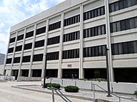
Saginaw County Governmental Center in Saginaw
|
|||
|
|||

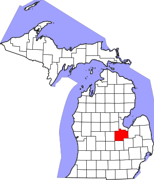
Location within the U.S. state of Michigan
|
|||
 Michigan's location within the U.S. |
|||
| Country | |||
| State | |||
| Founded | February 9, 1835 | ||
| Seat | Saginaw | ||
| Largest city | Saginaw | ||
| Area | |||
| • Total | 816 sq mi (2,110 km2) | ||
| • Land | 800 sq mi (2,000 km2) | ||
| • Water | 16 sq mi (40 km2) 1.9%% | ||
| Population
(2020)
|
|||
| • Total | 190,124 | ||
| • Density | 250/sq mi (100/km2) | ||
| Time zone | UTC−5 (Eastern) | ||
| • Summer (DST) | UTC−4 (EDT) | ||
| Congressional district | 8th | ||
Saginaw County (pronounced sag-UH-naw) is a county located in the state of Michigan. In 2020, about 190,124 people lived there. The main city and county seat is Saginaw. The county was officially created on February 9, 1835.
The name "Saginaw" has a few possible meanings. It might come from Native American words like Sace-nong or Sak-e-nong, which could mean "Sauk land." Some believe the Sauk tribe once lived there. Another idea is that it comes from Ojibwe words meaning "place of the outlet." This refers to a place where water flows out, like a river emptying into a lake.
Saginaw County is part of the Saginaw, MI Metropolitan Statistical Area. This means it's a busy area with many people and businesses. It's also part of a larger area called the Saginaw-Midland-Bay City Combined Statistical Area, which is the 5th largest metropolitan area in Michigan.
Contents
- What's in a Name? The Story of Saginaw
- A Look Back: Saginaw County's History
- Exploring Saginaw County's Geography
- =Main Rivers
- =Wildlife Refuge
- =Neighboring Counties
- People of Saginaw County
- =Religion
- Saginaw County's Economy
- Getting Around: Transportation in Saginaw County
- =Airports
- =Highways
- =Waterways
- Learning in Saginaw County: Education
- =Schools for Kids and Teens
- =Colleges and Universities
- Famous People from Saginaw County
- Historical Markers
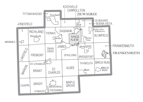
- Communities in Saginaw County
- =Cities
- =Villages
- =Charter Townships
- =Civil Townships
- =Census-Designated Places
- =Other Small Communities
- Images for kids
- See also
What's in a Name? The Story of Saginaw
The name Saginaw is thought to mean "where the Sauk were" in the Ojibwe language. This idea comes from words like Sace-nong or Sak-e-nong, which mean "Sauk Town." People believed the Sauk tribe once lived in this area.
However, it's more likely that the name means "place of the outlet." This comes from two Ojibwe words: sag (meaning "an opening") and ong (meaning "place of"). This fits because the Saginaw River flows into Lake Huron here.
Long ago, a French explorer named Samuel de Champlain heard about the Sauk nation. He thought they were on the western shore of Lake Huron, but they were actually on the western shore of Lake Michigan. This mistake was copied on maps, making people think Saginaw was the "place of the Sauks." Champlain himself never visited Michigan.
A Look Back: Saginaw County's History
People have lived in the Saginaw area for a very long time. From about 1000 B.C. to 1000 A.D., the Hopewell culture lived here. After them came the Anishnabeg people. Some historians think the Sauk tribe once lived here but were later moved out by the Ojibwe (Chippewa) tribe. This happened before Europeans first came to the area.
The Saginaw region has many rivers and streams that all flow into the Saginaw River. This network of waterways was very important for Native Americans. It made it easy for them to travel between their villages and hunting grounds. It also gave them access to Lake Huron. Saginaw was also a common meeting place for the Ojibwe, Pottawatomi, and Ottawa tribes. These three tribes were known as the Three Fires of the Anishnabeg.
When Euro-Americans first arrived, the Ojibwe people were the main group living in what is now Saginaw County. In the 1820s, the Ojibwe were still very strong in the area. In 1827, two groups of Winnebago people from Wisconsin attacked them. The Ojibwe won this fight with help from the local Euro-American settlers.
By 1853, the Ojibwe and Ottawa tribes still had large hunting camps along the Saginaw River. But at the same time, Euro-American settlers were starting to build sawmills and farms in the area.
Exploring Saginaw County's Geography
Saginaw County covers a total area of 816 square miles. About 800 square miles of this is land, and 16 square miles (1.9%) is water. It's part of the Flint/Tri-Cities region in Mid-Michigan. The average height above sea level in Saginaw County is about 620 feet.
=Main Rivers
=Wildlife Refuge
- Shiawassee National Wildlife Refuge is a special area set aside to protect wild animals and their homes.
=Neighboring Counties
- Bay County (to the northeast)
- Midland County (to the northwest)
- Tuscola County (to the east)
- Gratiot County (to the west)
- Genesee County (to the southeast)
- Shiawassee County (to the south)
- Clinton County (to the southwest)
People of Saginaw County
| Historical population | |||
|---|---|---|---|
| Census | Pop. | %± | |
| 1840 | 892 | — | |
| 1850 | 2,609 | 192.5% | |
| 1860 | 12,693 | 386.5% | |
| 1870 | 39,097 | 208.0% | |
| 1880 | 59,095 | 51.1% | |
| 1890 | 82,273 | 39.2% | |
| 1900 | 81,222 | −1.3% | |
| 1910 | 89,290 | 9.9% | |
| 1920 | 100,286 | 12.3% | |
| 1930 | 120,717 | 20.4% | |
| 1940 | 130,468 | 8.1% | |
| 1950 | 153,515 | 17.7% | |
| 1960 | 190,752 | 24.3% | |
| 1970 | 219,743 | 15.2% | |
| 1980 | 228,059 | 3.8% | |
| 1990 | 211,946 | −7.1% | |
| 2000 | 210,039 | −0.9% | |
| 2010 | 200,169 | −4.7% | |
| 2020 | 190,124 | −5.0% | |
| 2023 (est.) | 187,782 | −6.2% | |
| U.S. Decennial Census 1790–1960 1900–1990 1990–2000 2010–2019 |
|||
The 2010 United States Census showed that Saginaw County had 200,169 people. This was a decrease of about 9,870 people from the 2000 United States Census. Overall, the county's population went down by 4.7% during those ten years.
In 2010, there were 79,011 households and 52,287 families in the county. The population density was about 250 people per square mile. There were 86,844 housing units, which are homes or apartments.
The county's population was made up of different groups:
- 70.5% White
- 18.6% Black or African American
- 0.3% Native American
- 1.0% Asian
- 7.8% Hispanic or Latino
- 0.1% from other races
- 1.6% from two or more races
About 30.5% of households had children under 18 living with them. About 45.4% were husband and wife families. The average household had 2.44 people, and the average family had 2.99 people.
About 23.4% of the population was under 18 years old. About 15.3% were 65 years or older. The average age in the county was 40 years.
The 2010 American Community Survey estimated that the average income for a household was $41,938. For a family, the average income was $52,243. About 12.4% of families and 16.9% of all people were living below the poverty line. This included 24.1% of those under 18 and 10.1% of those 65 or older.
=Religion
The Roman Catholic Diocese of Saginaw is the main organization for the Catholic Church in this region.
Saginaw County's Economy
The biggest employers in Saginaw County are listed below. An employer is a company or organization that hires people to work.
| # | Employer | # of employees |
|---|---|---|
| 1 | Nexteer Automotive | 5200 |
| 2 | Covenant HealthCare | 4512 |
| 3 | St. Mary's of Michigan | 1800 |
| 4 | Morley Companies | 1750 |
| 5 | Meijer | 1425 |
| 6 | Saginaw Valley State University | 1071 |
| 7 | Hemlock Semiconductor Corporation | 1000 |
| 8 | Frankenmuth Bavarian Inn | 940 |
| 9 | Aleda E. Lutz Veteran Affairs Medical Center | 904 |
| 10 | County of Saginaw | 676 |
| 11 | Saginaw Public Schools | 657 |
| 12 | Fashion Square Mall | 650 |
| 13 | Saginaw Township Community Schools | 621 |
| 14 | Saginaw Intermediate School District | 613 |
| 15 | Frankenmuth Insurance | 694 |
Getting Around: Transportation in Saginaw County
Saginaw County was once the end point of a Native American path called the Saginaw Trail. This path later became one of the first roads in Michigan. The trail was approved in 1819 and finished in Saginaw by 1841. Since then, Saginaw has gained many ways to connect with the outside world. These include water travel, trains, airplanes, and highways.
=Airports
You can find scheduled flights at MBS International Airport near Freeland, Michigan. Another option is Bishop International Airport in Flint, Michigan. Harry Browne Airport in Buena Vista Charter Township also serves the area.
=Highways
 I-75 is a major highway that runs north and south. It goes all the way from Sault Ste. Marie, Michigan to Miami-Dade County, Florida.
 I-675 is a smaller highway that goes through downtown Saginaw.
 US 23
US 23 M-13 runs from I-69 through downtown Saginaw and north to Standish.
 M-15
M-15 M-30
M-30 M-46 is a road that crosses Michigan from east to west. It goes from Port Sanilac on the Lake Huron shore, through Saginaw near Saginaw Bay, and then to Muskegon on the Lake Michigan shore.
 M-47 goes through the western suburbs. It connects directly to MBS International Airport in Freeland before ending at US 10 in nearby Bay County.
 M-52 runs from the Ohio border through Adrian and Owosso. It ends at M-46 in the western suburbs of Saginaw. M-52 also offers another way to get to Lansing, Michigan's state capital.
 M-54
M-54 M-57
M-57 M-58 runs from M-47 to I-675.
 M-81 runs east from M-13 to Caro and Cass City. It ends at M-53 in Sanilac County.
 M-83
M-83 M-84 runs from M-25 in downtown Bay City to M-58 in Saginaw.
=Waterways
The Saginaw River is kept open for boats by the Corps of Engineers. They sometimes dredge (dig out) the river to keep a shipping channel clear. This channel goes down the river to Bay City and then out to the Great Lakes.
Learning in Saginaw County: Education
=Schools for Kids and Teens
Public Schools
Most of Saginaw County is served by the Saginaw Intermediate School District (SISD). This district helps local school boards work together, but it doesn't run the schools day-to-day. Local school boards in Michigan have a lot of control over how their schools operate. There are also several charter schools in the county.
Here are some of the school districts in Saginaw County:
- Ashley Community Schools
- Bay City School District
- Birch Run Area School District
- Breckenridge Community Schools
- Bridgeport-Spaulding Community School District
- Carrollton School District
- Chesaning Union Schools
- Clio Area School District
- Frankenmuth School District
- Freeland Community School District
- Hemlock Public School District
- Merrill Community Schools
- Montrose Community Schools
- New Lothrop Area Public School
- Ovid-Elsie Area Schools
- Reese Public Schools
- Saginaw City School District
- Saginaw Township Community Schools
- St. Charles Community Schools
- Swan Valley School District
=Colleges and Universities
- Saginaw Valley State University (SVSU) is a four-year state university. It's located in eastern Kochville Township.
- Delta College is a two-year community college. It serves Saginaw County but is located in nearby Bay County, a few miles north of the SVSU campus.
Famous People from Saginaw County
- George C. Hinkley (1892-1936) was a Wisconsin State Assemblyman and businessman. He was born in Saginaw County.
- Theodore Roethke (1908–1963) was a poet who won the Pulitzer Prize and National Book Award. He was born and buried here.
Historical Markers
There are twenty-eight special historical markers in Saginaw County. These markers tell about important places and events from the past. Some of them are:
- Bliss Park
- Burt Opera House / Wellington R. Burt
- Coal Mine No. 8
- The Cushway House / Benjamin Cushway and Adelaide Cushway
- First Congregational Church [Saginaw]
- Fowler Schoolhouse (Fremont Township)
- Frankenmuth / Saint Lorenz Evangelical Lutheran Church
- Frankenmuth Bavarian Inn
- Freeland United Methodist Church
- George Nason House
- Hess School
- Hoyt Library
- Leamington Stewart House
- Michigan's German Settlers
- Morseville Bridge
- Presbyterian Church of South Saginaw
- Saginaw Club
- Saginaw Oil Industry
- Saginaw Post Office
- Saginaw Valley Coal
- Saginaw Valley Lumbering Era
- St. Mary's Hospital
- Saint Michael Catholic Parish
- St. Paul's Episcopal Mission
- Shroeder House
- Theodore Roethke / Childhood Home
Communities in Saginaw County
=Cities
- Frankenmuth
- Saginaw (the main city and county seat)
- Zilwaukee
=Villages
=Charter Townships
- Bridgeport Charter Township
- Buena Vista Charter Township
- Saginaw Charter Township
=Civil Townships
- Albee Township
- Birch Run Township
- Blumfield Township
- Brady Township
- Brant Township
- Carrollton Township
- Chapin Township
- Chesaning Township
- Frankenmuth Township
- Fremont Township
- James Township
- Jonesfield Township
- Kochville Township
- Lakefield Township
- Maple Grove Township
- Marion Township
- Richland Township
- Spaulding Township
- St. Charles Township
- Swan Creek Township
- Taymouth Township
- Thomas Township
- Tittabawassee Township
- Zilwaukee Township
=Census-Designated Places
These are areas that are like towns but are not officially incorporated as cities or villages.
=Other Small Communities
- Alicia
- Blumfield Corners
- Brady Center
- Brant
- Chapin
- Clausedale
- Crow Island
- Dice
- Fenmore
- Fergus
- Fordney
- Fosters
- Frankentrost
- Frost
- Galloway
- Garfield
- Gera
- Groveton
- Indiantown
- Iva
- Kochville
- Lakefield
- Lawndale
- Layton Corners
- Luce
- Marion Springs
- Morseville
- Nelson
- Orr
- Racy
- Paines
- Parshallburg
- Roosevelt
- Shattuckville
- Swan Creek
- Taymouth
Images for kids
See also
 In Spanish: Condado de Saginaw para niños
 | Claudette Colvin |
 | Myrlie Evers-Williams |
 | Alberta Odell Jones |


