Bay County, Michigan facts for kids
Quick facts for kids
Bay County
|
||
|---|---|---|

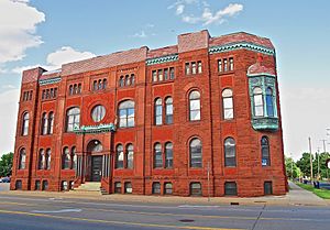
Bay City Masonic Temple.
|
||
|
||

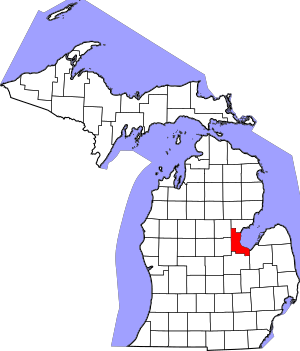
Location within the U.S. state of Michigan
|
||
 Michigan's location within the U.S. |
||
| Country | ||
| State | ||
| Founded | February 17, 1857 | |
| Named for | Saginaw Bay | |
| Seat | Bay City | |
| Largest city | Bay City | |
| Area | ||
| • Total | 631 sq mi (1,630 km2) | |
| • Land | 442 sq mi (1,140 km2) | |
| • Water | 188 sq mi (490 km2) 30%% | |
| Population
(2020)
|
||
| • Total | 103,856 | |
| • Density | 236/sq mi (91/km2) | |
| Time zone | UTC−5 (Eastern) | |
| • Summer (DST) | UTC−4 (EDT) | |
| Congressional district | 8th | |
Bay County is a county located in the state of Michigan, USA. As of the 2020 Census, about 103,856 people lived here. The main city and county seat is Bay City.
Bay County is part of the Bay City, MI Metropolitan Statistical Area. It is also included in the larger Saginaw-Midland-Bay City area in the Mid/Central Michigan region.
Contents
History
How Bay County Was Created
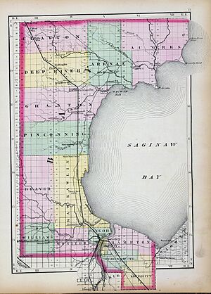
Bay County was formed in 1857. It was created from parts of Midland County, Saginaw County, and Arenac County. The name "Bay County" comes from the fact that it "surrounds Saginaw Bay."
At first, many leaders in Saginaw and Midland counties did not want Bay County to be created. In 1854, a plan to create the county was voted down.
In 1857, a new plan was introduced. After some debate, a compromise was reached. The plan would be voted on by the people in the proposed new county. On February 17, 1857, the state legislature approved this plan. The people living within the proposed Bay County boundaries voted yes. So, the county officially started on April 20, 1857.
A Legal Battle
Even after the vote, Saginaw County did not fully accept the new county. In 1857, Bay County residents held elections for their own officials. But Saginaw County still claimed control.
A lawyer named Chester H. Freeman worked to make Bay County's status clear. In 1858, a case went to the Michigan Supreme Court. A person was tried in Saginaw County, but their lawyer argued the crime happened in Bay County. This meant Saginaw County did not have the right to try the case. The Supreme Court agreed, and Bay County was officially declared a fully organized county.
Later History
During World War II, shipyards in Bay County were very important. They built US Destroyers and missile ships to help with the war effort.
In 1978, Bay County became one of the first counties in Michigan to adopt a "County Executive" form of government. This means there is an elected County Executive who leads many parts of the county government. This person can also say no to (veto) decisions made by the County Commission.
Since then, Bay County has had four County Executives:
- Gary Majeske (1979–1989)
- Kim Higgs (1989–1993)
- Thomas Hickner (1993–2016)
- James Barcia (2017–present)
Geography

Bay County covers a total area of about 631 square miles. Of this, 442 square miles is land, and 188 square miles (30%) is water. It is one of Michigan's smaller counties by land area.
The Saginaw River flows through Bay City. The Kawkawlin River drains much of the middle part of the county. The Pinconning River and Saganing Creek drain the northern part. The Saginaw Bay of Lake Huron is to the east, which is how the county got its name.
Major Roads
 I-75
I-75 BS I-75
 US 10
US 10
 Bus. US 10
 US 23
US 23 M-13
M-13
 Conn. M‑13
 M-15
M-15 M-20
M-20 M-25
M-25 M-47
M-47 M-61
M-61 M-84
M-84- M-138
- M-247
Interstate 75 (I-75) and U.S. Highway 23 (US 23) are the main north-south roads. They run together through the county. North of Bay City, M-13 runs a few miles to the east. US 10 ends in Bay City. Other state roads like M-25, M-15, and M-84 also enter Bay City.
Neighboring Counties
Bay County shares borders with these counties:
- Arenac County (north)
- Gladwin County (northwest)
- Tuscola County (southeast)
- Midland County (west)
- Saginaw County (south)
People and Population
| Historical population | |||
|---|---|---|---|
| Census | Pop. | %± | |
| 1860 | 3,164 | — | |
| 1870 | 15,900 | 402.5% | |
| 1880 | 38,081 | 139.5% | |
| 1890 | 56,412 | 48.1% | |
| 1900 | 62,378 | 10.6% | |
| 1910 | 68,238 | 9.4% | |
| 1920 | 69,548 | 1.9% | |
| 1930 | 69,474 | −0.1% | |
| 1940 | 74,981 | 7.9% | |
| 1950 | 88,461 | 18.0% | |
| 1960 | 107,042 | 21.0% | |
| 1970 | 117,339 | 9.6% | |
| 1980 | 119,881 | 2.2% | |
| 1990 | 111,723 | −6.8% | |
| 2000 | 110,157 | −1.4% | |
| 2010 | 107,771 | −2.2% | |
| 2020 | 103,856 | −3.6% | |
| 2023 (est.) | 102,500 | −4.9% | |
| U.S. Decennial Census 1790-1960 1900-1990 1990-2000 2010-2018 |
|||
The 2010 United States Census showed that Bay County had 107,771 people. This was a small decrease from the year 2000. The population density was about 243.7 people per square mile.
In 2010, there were 44,603 households. About 28.5% of these households had children under 18 living with them. The average household had 2.38 people.
The population was spread out by age:
- 22.2% were under 18 years old.
- 8.5% were from 18 to 24.
- 23.6% were from 25 to 44.
- 29.5% were from 45 to 64.
- 16.2% were 65 years or older.
The average age in the county was 42 years.
The 2010 survey showed that the average income for a household was $45,451. For families, the average income was $52,784. About 16.2% of the population lived below the poverty line. This included 23.7% of those under 18.
Religion
The Roman Catholic Diocese of Saginaw oversees the Catholic Church in this region.
Economy
Bay County has several large employers. Here are the top ones:
| # | Employer | # of Employees |
|---|---|---|
| 1 | McLaren - Bay Region | 2,083 |
| 2 | The Dow Chemical Company | 1,160 |
| 3 | Delta College | 957 |
| 4 | Michigan Sugar | 900 |
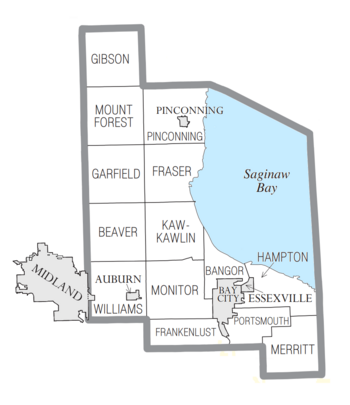
Communities
Cities
- Auburn
- Bay City (the main city and county seat)
- Essexville
- Pinconning
- Midland (partially in Bay County)
Charter Townships
- Bangor Charter Township
- Hampton Charter Township
- Monitor Charter Township
- Portsmouth Charter Township
- Williams Charter Township
Civil Townships
Unincorporated Communities
- Almeda Beach
- Amelith
- Aplin Beach
- Arn
- Beaver
- Bentley
- Brissette Beach
- Brooks
- Crump
- Donahue Beach
- Duel
- Fisherville
- Frankenlust
- Kawkawlin
- Killarney Beach
- Lagoon Beach
- Linwood
- Linwood Beach
- Little Killarney Beach
- Loehne
- Meyers Beach
- Mount Forest
- Munger
- Nine Mile
- North Williams
- Seidlers
- Three Churches Corner
- Tobico Beach
- Willard
- Woodville
- University Center
Former City
See also
 In Spanish: Condado de Bay (Míchigan) para niños
 | Dorothy Vaughan |
 | Charles Henry Turner |
 | Hildrus Poindexter |
 | Henry Cecil McBay |


