Gladwin County, Michigan facts for kids
Quick facts for kids
Gladwin County
|
||
|---|---|---|

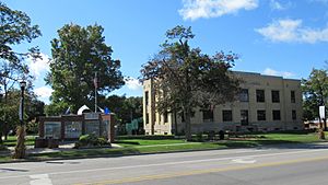
Gladwin County Courthouse in Gladwin
|
||
|
||

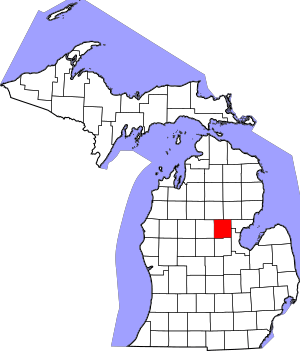
Location within the U.S. state of Michigan
|
||
 Michigan's location within the U.S. |
||
| Country | ||
| State | ||
| Founded | 1831 (created) 1875 (organized) |
|
| Named for | Henry Gladwin | |
| Seat | Gladwin | |
| Largest city | Gladwin | |
| Area | ||
| • Total | 516 sq mi (1,340 km2) | |
| • Land | 502 sq mi (1,300 km2) | |
| • Water | 14 sq mi (40 km2) 2.7%% | |
| Population
(2020)
|
||
| • Total | 25,386 | |
| • Density | 51/sq mi (20/km2) | |
| Time zone | UTC−5 (Eastern) | |
| • Summer (DST) | UTC−4 (EDT) | |
| Congressional district | 2nd | |
Gladwin County is a county in the state of Michigan. In 2020, about 25,386 people lived here. The main town, or county seat, is Gladwin.
Contents
History of Gladwin County
Ancient Times and Early People
Gladwin County is a "headwaters" area. This means most of the water in the Tittabawassee River starts here. Only a small amount flows in from other counties.
Long ago, Native Americans traveled through this area. They often spent their summers here. It was a good place for fishing, and there were many summer berries.
Researchers are studying an old trail. Surveyors noted it in 1839. This trail might have been a route from Saginaw Bay to Lake Michigan. People would travel by canoe up rivers. Then, they would carry their canoes along the trail to the Muskegon River. From there, they could float down to Lake Michigan.
Many old tools and items have been found along this route. These show that people stayed here during certain seasons. However, there is no sign of a permanent village yet.
First European Visitors
The first recorded visitors to the area were surveyors. They mapped the land in the 1830s. This was done under the Northwest Ordinance of 1787. Some of their early maps were not perfect. The surveyors thought no one would ever live in this area.
The first official count of people in the area was in 1860.
The county is named after Henry Gladwin. He was a British military leader in Detroit in 1763. This was during Pontiac's War. Gladwin County was officially created in 1831. Its government was set up in 1875.
Early Settlers and Growth
The year 2011 marked 150 years since the first known permanent settler arrived. His name was Marvel Secord. He settled along the Tittabawassee River. This area is now called Secord Township. He was a trapper and trader. He sold supplies to the lumber camps nearby.
Another man, William Brayton, might have settled even earlier. The 1860 census listed 14 residents. This included two families with children. Most of these people worked in lumber camps. Three were listed as "hunters."
William Brayton was a farmer. He grew wheat. His stepson, Dr. Russell E. Finch, arrived in 1875. He became the county's first doctor. William Brayton died in 1895. He is thought to be the first permanent settler.
Geography of Gladwin County
Gladwin County covers about 516 square miles. About 502 square miles are land. The remaining 14 square miles (2.7%) are water. It is the second-smallest county in Michigan by total area. Gladwin County is sometimes seen as part of Central Michigan. Other times, it is included in Northern Michigan.
Main Roads
 M-18: This road runs north to south. It goes through the western part of the county. It passes through Gladwin and Beaverton.
 M-30: This road enters the northeastern part of the county. It runs west, then turns south. It passes through White Star and Billings.
 M-61: This road runs east to west. It goes through the middle of the county. It passes through Gladwin and White Star.
County Roads
 F-97
F-97
Neighboring Counties
- Ogemaw County – northeast
- Arenac County – east
- Bay County – southeast
- Midland County – south
- Clare County – west
- Isabella County – southwest
- Roscommon County – northwest
Population of Gladwin County
| Historical population | |||
|---|---|---|---|
| Census | Pop. | %± | |
| 1880 | 1,127 | — | |
| 1890 | 4,208 | 273.4% | |
| 1900 | 6,564 | 56.0% | |
| 1910 | 8,413 | 28.2% | |
| 1920 | 8,827 | 4.9% | |
| 1930 | 7,424 | −15.9% | |
| 1940 | 9,385 | 26.4% | |
| 1950 | 9,451 | 0.7% | |
| 1960 | 10,769 | 13.9% | |
| 1970 | 13,471 | 25.1% | |
| 1980 | 19,957 | 48.1% | |
| 1990 | 21,896 | 9.7% | |
| 2000 | 26,023 | 18.8% | |
| 2010 | 25,692 | −1.3% | |
| 2020 | 25,386 | −1.2% | |
| 2023 (est.) | 25,853 | 0.6% | |
| US Decennial Census 1790-1960 1900-1990 1990-2000 2010-2018 |
|||
In 2000, there were 26,023 people living in Gladwin County. Most people (97.65%) were White. About 0.56% were Native American. The average household had 2.43 people. The average family had 2.85 people.
The median age in the county was 42 years old. For every 100 females, there were about 98.5 males.
Towns and Communities
Cities
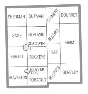
Townships
- Beaverton Township
- Bentley Township
- Billings Township
- Bourret Township
- Buckeye Township
- Butman Township
- Clement Township
- Gladwin Township
- Grim Township
- Grout Township
- Hay Township
- Sage Township
- Secord Township
- Sherman Township
- Tobacco Township
Other Communities
- Albright Shores
- Billings
- Butman
- Dale
- Estey
- Hockaday
- Lockwood Beach
- Rhodes
- Secord
- Skeels
- Sugar Rapids
- White Star
- Wildwood Shores
- Winegars
- Wooden Shoe Village
Old Town (Ghost Town)
Education in Gladwin County
The Clare-Gladwin Regional Education Service District helps students in Gladwin County. It is based in Clare. This district offers special education services. It also has programs for young children and after-school activities. Students can also learn skills for different careers.
Gladwin County has these public school districts:
- Beaverton Schools
- Gladwin Community Schools
There are also private schools in Gladwin County:
- Lilac Grove Amish School (for Amish children)
- Meadow Brook (for Amish children)
- Skeels Christian School (a Baptist school)
- Southwell Amish School (for Amish children)
See also
 In Spanish: Condado de Gladwin para niños
 | May Edward Chinn |
 | Rebecca Cole |
 | Alexa Canady |
 | Dorothy Lavinia Brown |


