Isabella County, Michigan facts for kids
Quick facts for kids
Isabella County
|
|||
|---|---|---|---|

|
|||
|
|||

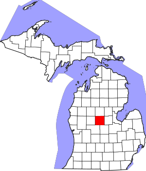
Location within the U.S. state of Michigan
|
|||
 Michigan's location within the U.S. |
|||
| Country | |||
| State | |||
| Founded | 1831 (created) 1859 (organized) |
||
| Named for | Queen Isabella I of Castile | ||
| Seat | Mount Pleasant | ||
| Largest city | Mount Pleasant | ||
| Area | |||
| • Total | 578 sq mi (1,500 km2) | ||
| • Land | 573 sq mi (1,480 km2) | ||
| • Water | 5.0 sq mi (13 km2) 0.9%% | ||
| Population
(2020)
|
|||
| • Total | 64,394 | ||
| • Density | 124/sq mi (48/km2) | ||
| Time zone | UTC−5 (Eastern) | ||
| • Summer (DST) | UTC−4 (EDT) | ||
| Congressional district | 2nd | ||
Isabella County is a county located in the state of Michigan. In 2020, about 64,394 people lived here. Its main city, or county seat, is Mount Pleasant.
Long ago, this area was known as Ojibiway Besse. This means "the place of the Ojibwa" in their language. Isabella County is also home to the Isabella Indian Reservation. Members of the Saginaw Chippewa Tribal Nation live on this reservation.
Contents
History of Isabella County
How Isabella County Was Formed
Isabella County was first marked out in 1831. This was done by the government of the Michigan Territory. At first, it was part of other nearby counties. This was for things like counting people and collecting money.
Michigan became a state in early 1837. By 1859, enough people lived in Isabella County. They wanted to govern themselves. So, the state government allowed it to become its own organized county.
Naming the County
The county was named after Queen Isabella I of Castile. She was a queen in Spain. She and her husband, King Ferdinand, helped fund Christopher Columbus's trip to the New World.
This name was suggested by Henry Rowe Schoolcraft. He was a U.S. Indian agent in the area. Isabella County is now part of the Mount Pleasant, Michigan area in Mid-Michigan.
Isabella Indian Reservation
The county includes the Isabella Indian Reservation. This reservation covers about 217.67 square miles. It is the main land area for the Saginaw Chippewa Tribal Nation. Part of Mount Pleasant, the county seat, is also on the reservation.
Geography of Isabella County
Land and Water Areas
Isabella County covers a total area of 578 square miles. Most of this is land, about 573 square miles. The rest, about 5.0 square miles, is water. This means water makes up about 0.9% of the county's total area.
Major Roads
 US 10: This road goes across the northeast part of the county. It enters from Clare and heads southeast.
 US 127: This road runs north to south through the middle-eastern part of the county. It passes through Rosebush and Mount Pleasant.
 M-20: This road goes east to west across the lower central part of the county. It enters from Remus and ends in Mount Pleasant.
Neighboring Counties
Isabella County shares borders with several other counties:
- Clare County – to the north
- Gladwin County – to the northeast
- Midland County – to the east
- Gratiot County – to the southeast
- Montcalm County – to the southwest
- Mecosta County – to the west
- Osceola County – to the northwest
Population of Isabella County
| Historical population | |||
|---|---|---|---|
| Census | Pop. | %± | |
| 1860 | 1,443 | — | |
| 1870 | 4,113 | 185.0% | |
| 1880 | 12,159 | 195.6% | |
| 1890 | 18,784 | 54.5% | |
| 1900 | 22,784 | 21.3% | |
| 1910 | 23,029 | 1.1% | |
| 1920 | 22,610 | −1.8% | |
| 1930 | 21,126 | −6.6% | |
| 1940 | 25,982 | 23.0% | |
| 1950 | 28,964 | 11.5% | |
| 1960 | 35,348 | 22.0% | |
| 1970 | 44,594 | 26.2% | |
| 1980 | 54,110 | 21.3% | |
| 1990 | 54,624 | 0.9% | |
| 2000 | 63,351 | 16.0% | |
| 2010 | 70,311 | 11.0% | |
| 2020 | 64,394 | −8.4% | |
| 2023 (est.) | 64,118 | −8.8% | |
| US Decennial Census 1790-1960 1900-1990 1990-2000 2010-2018 |
|||
In 2000, there were 63,351 people living in Isabella County. The population density was about 110 people per square mile. The county had 22,425 households. About 28.4% of these households had children under 18 living with them.
The median age in the county was 25 years old. This means half the people were younger than 25 and half were older. About 20.3% of the population was under 18. Also, 29.4% were between 18 and 24 years old.
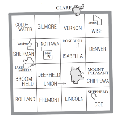
Communities in Isabella County

Cities
- Clare (part of this city is in Isabella County)
- Mount Pleasant (this is the county seat)
Villages
Charter Township
- Union Charter Township
Civil Townships
- Broomfield Township
- Chippewa Township
- Coe Township
- Coldwater Township
- Deerfield Township
- Denver Township
- Fremont Township
- Gilmore Township
- Isabella Township
- Lincoln Township
- Nottawa Township
- Rolland Township
- Sherman Township
- Vernon Township
- Wise Township
Census-Designated Places
These are areas that are like towns but are not officially incorporated as cities or villages.
Unincorporated Communities
These are smaller communities that are not officially part of a city or village.
- Alembic
- Blanchard
- Brinton
- Coe
- Delwin
- Leaton
- Sherman City
- Two Rivers
- Vernon Center
- Vernon City
Indian Reservation
Education in Isabella County
Regional Education Services
The Gratiot–Isabella Regional Education Service District helps students in the county. It is based in Ithaca. This district offers special education services. It also has programs for young children. Plus, it provides career training pathways for students.
Public School Districts
Isabella County has several public school districts:
- Beal City Public Schools
- Mt. Pleasant City School District
- Shepherd Public Schools
Independent Charter Schools
The county also has independent charter schools:
- Flextech High School - Shepherd
- Renaissance Public School Academy
Private Schools
Isabella County has these private schools:
- Sacred Heart Academy (a Roman Catholic school)
- Saginaw Chippewa Academy (not connected to a specific religion)
- St. Joseph the Worker School (a Roman Catholic school)
- White Pine Montessori Children's Center (uses the Montessori teaching method)
See also
 In Spanish: Condado de Isabella para niños
 | Isaac Myers |
 | D. Hamilton Jackson |
 | A. Philip Randolph |


