
Shepherd, Michigan facts for kids
Quick facts for kids
Shepherd, Michigan
|
|
|---|---|
|
Village
|
|
| Village of Shepherd | |

Looking west along W. Wright Avenue
|
|
,_MI_location.png)
Location within Isabella County
|
|

Shepherd, Michigan
Location in Michigan

Shepherd, Michigan
Location in the United States
|
|
| Country | United States |
| State | Michigan |
| County | Isabella |
| Township | Coe |
| Established | 1857 |
| Platted | 1866 |
| Incorporated | 1889 |
| Government | |
| • Type | Village council |
| Area | |
| • Total | 0.96 sq mi (2.49 km2) |
| • Land | 0.96 sq mi (2.49 km2) |
| • Water | 0.00 sq mi (0.00 km2) |
| Elevation | 774 ft (236 m) |
| Population
(2020)
|
|
| • Total | 1,469 |
| • Density | 1,535.01/sq mi (592.56/km2) |
| Time zone | UTC-5 (Eastern (EST)) |
| • Summer (DST) | UTC-4 (EDT) |
| ZIP code(s) |
48883
|
| Area code(s) | 989 |
| FIPS code | 26-72960 |
| GNIS feature ID | 0637740 |
Shepherd is a small village located in Isabella County, Michigan, in the United States. In 2020, about 1,469 people lived there. The village is part of Coe Township.
Contents
Discovering Shepherd's Past: A Brief History
Shepherd was first settled by a lumberman named Isaac Shepherd and others. They built homes along the Salt River. The community got its first post office in 1857, called Salt River. The area was officially mapped out in 1866.
In 1885, railroads came to the area. A train station was built on Isaac Shepherd's land and was named Shepherd. The post office also changed its name to Shepherd in 1887. A big fire destroyed most of the community that same year. But the people quickly rebuilt it. Shepherd officially became a village in 1889.
Since 1958, Shepherd has hosted a special event each year. It's called the Shepherd Maple Syrup Festival. This festival has grown to include many fun things. You can find exhibits, crafts, music, and lots of delicious food. There's even a parade!
Exploring Shepherd's Location and Climate
Shepherd is a small place, covering about 0.96 square miles (2.49 square kilometers) of land.
How to Get to Shepherd: Major Highways
A main road, US-127, runs just east of Shepherd. You can easily reach the village from this highway by taking exit 135 (Blanchard Road).
Shepherd's Weather: Understanding the Climate
Shepherd has a type of weather called a humid continental climate. This means it has big changes in temperature throughout the year. Summers are warm or hot, and often humid. Winters are cold, and sometimes very cold.
Who Lives in Shepherd: Population and People
| Historical population | |||
|---|---|---|---|
| Census | Pop. | %± | |
| 1890 | 469 | — | |
| 1900 | 635 | 35.4% | |
| 1910 | 835 | 31.5% | |
| 1920 | 823 | −1.4% | |
| 1930 | 839 | 1.9% | |
| 1940 | 852 | 1.5% | |
| 1950 | 899 | 5.5% | |
| 1960 | 1,293 | 43.8% | |
| 1970 | 1,416 | 9.5% | |
| 1980 | 1,534 | 8.3% | |
| 1990 | 1,413 | −7.9% | |
| 2000 | 1,536 | 8.7% | |
| 2010 | 1,515 | −1.4% | |
| 2020 | 1,469 | −3.0% | |
| U.S. Decennial Census | |||
Shepherd's Community in 2010
In 2010, there were 1,515 people living in Shepherd. These people lived in 640 homes. About 412 of these homes were families. The village had about 1,562 people per square mile.
Most people in Shepherd were White (94.2%). A small number were African American, Native American, or Asian. Some people were from other backgrounds or had mixed races. About 3.2% of the population was Hispanic or Latino.
About 31.7% of homes had children under 18 living there. Many homes were married couples living together. Some homes had a single parent. About 30.8% of homes were single people living alone. The average age of people in Shepherd was 37.5 years old.
Famous Faces from Shepherd
- Len Kasper is a well-known radio announcer for the Chicago White Sox baseball team. He grew up right here in Shepherd!
Images for kids
-
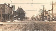
Historic image of Main Street (1911) -
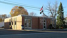
U.S. Post Office in Shepherd -
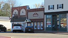
Village Hall / Police and Library
.jpg)


See also
 In Spanish: Shepherd para niños
