
Rosebush, Michigan facts for kids
Quick facts for kids
Rosebush, Michigan
|
|
|---|---|
|
Village
|
|
| Village of Rosebush | |
.jpg)
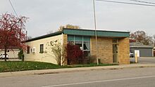
Looking east along E. Rosebush Road
|
|
,_MI_location.png)
Location within Isabella County
|
|

Rosebush, Michigan
Location in Michigan

Rosebush, Michigan
Location in the United States
|
|
| Country | United States |
| State | Michigan |
| County | Isabella |
| Township | Isabella |
| Settled | 1844 |
| Platted | 1868 |
| Government | |
| • Type | Village council |
| Area | |
| • Total | 0.89 sq mi (2.31 km2) |
| • Land | 0.89 sq mi (2.31 km2) |
| • Water | 0.00 sq mi (0.00 km2) |
| Elevation | 781 ft (238 m) |
| Population
(2020)
|
|
| • Total | 353 |
| • Density | 396.63/sq mi (153.14/km2) |
| Time zone | UTC-5 (Eastern (EST)) |
| • Summer (DST) | UTC-4 (EDT) |
| ZIP code(s) |
48878
|
| Area code(s) | 989 |
| FIPS code | 26-69640 |
| GNIS feature ID | 0636218 |
Rosebush is a small village located in Isabella County, in the state of Michigan, USA. In 2020, about 353 people lived there. This village is part of Isabella Township. It is also completely inside the Isabella Indian Reservation, which is the home of the Saginaw Chippewa Tribal Nation.
Contents
History of Rosebush Village
Rosebush started in 1844 when a man named Cornelius Bogan opened a general store. He first called the town Halfway. This was because it was about halfway between the towns of Clare and Mount Pleasant.
How Rosebush Got Its Name
In 1868, the Ann Arbor Railroad built tracks through the area. A resident named James Bush owned land there. When he officially mapped out the land for the town, he made a deal with the railroad. He gave them some of his property. In return, the train station was named after his wife, Rose.
Changes to the Village Name
Later, in 1873, another part of the community was mapped out by Elias B. Calkins. This new area was called Calkinsville. The first post office, opened on July 9, 1873, also used the name Calkinsville. The post office name changed to Rosebush in 1889. Then it changed back to Calkinsville in 1890. Finally, on February 19, 1903, it became Rosebush again. The name has stayed Rosebush ever since.
Geography of Rosebush
Rosebush is a small village. According to the U.S. Census Bureau, the village covers an area of about 0.89 square miles (2.31 square kilometers). All of this area is land.
Main Roads in Rosebush
- US 127 is a major highway that runs along the eastern edge of the village. You can get into Rosebush from this highway at exit 149, which is Rosebush Road.
People Living in Rosebush
The number of people living in Rosebush has changed over the years. Here's a quick look at the population counts from different years:
| Historical population | |||
|---|---|---|---|
| Census | Pop. | %± | |
| 1970 | 439 | — | |
| 1980 | 336 | −23.5% | |
| 1990 | 333 | −0.9% | |
| 2000 | 379 | 13.8% | |
| 2010 | 368 | −2.9% | |
| 2020 | 353 | −4.1% | |
| U.S. Decennial Census | |||
Rosebush in 2010
In 2010, the village of Rosebush had 368 people living there. These people lived in 170 households, and 89 of these were families.
Most of the people in Rosebush were White (88.6%). There were also people who identified as African American (1.1%), Native American (3.8%), and people from other backgrounds. About 6.3% of the population identified as Hispanic or Latino.
The average age of people in Rosebush in 2010 was 39 years old.
- About 19.8% of residents were under 18 years old.
- 14% were between 18 and 24.
- 22.9% were between 25 and 44.
- 26.3% were between 45 and 64.
- 17.1% were 65 years old or older.
More women lived in Rosebush than men in 2010. About 55.4% of the population was female, and 44.6% was male.
Images for kids
-
U.S. Post Office in Rosebush -
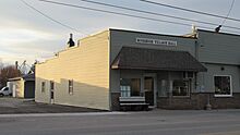
Rosebush Village Hall


See also
 In Spanish: Rosebush para niños
