Osceola County, Michigan facts for kids
Quick facts for kids
Osceola County
|
||
|---|---|---|

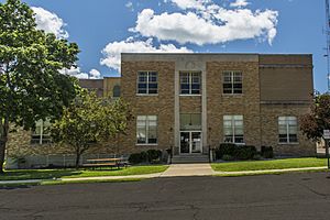
Osceola County Courthouse
|
||
|
||

Location within the U.S. state of Michigan
|
||
 Michigan's location within the U.S. |
||
| Country | ||
| State | ||
| Founded | April 1, 1840 (created) 1869 (organized) |
|
| Named for | Osceola | |
| Seat | Reed City | |
| Largest city | Reed City | |
| Area | ||
| • Total | 573 sq mi (1,480 km2) | |
| • Land | 566.39 sq mi (1,466.9 km2) | |
| • Water | 6.7 sq mi (17 km2) 1.2%% | |
| Population
(2020)
|
||
| • Total | 22,891 | |
| • Density | 41.4/sq mi (16.0/km2) | |
| Time zone | UTC−5 (Eastern) | |
| • Summer (DST) | UTC−4 (EDT) | |
| Congressional district | 2nd | |
Osceola County is a county in the state of Michigan, USA. It is pronounced OSS-ee-OH-lə. In 2020, about 22,891 people lived here. The main town and county seat is Reed City.
Contents
History of Osceola County
Osceola County was first created on April 1, 1840. It was named Unwattin County back then. This name honored Chief Unwattin, a leader of the local Ottawa people. Chief Unwattin helped with important talks for the Treaty of Washington (1836). This treaty gave a large part of Michigan to the U.S. government.
On March 8, 1843, the county's name was changed. It became Osceola County. This new name was chosen after a famous Seminole chief from Florida.
For many years, Osceola County was managed by other nearby counties. First, it was linked to Ottawa County. Later, it was connected to Mason County in 1855. Then, it moved to Newaygo County in 1857. Finally, it was managed by Mecosta County in 1859.
As more people moved to the area, Osceola County started its own government in 1869. The town of Hersey was chosen as the first county seat. Later, in 1927, Reed City became the official county seat. The county grew because of the lumber industry. Many people from Europe came to work in the forests and sawmills.
Geography of Osceola County
Osceola County has gentle rolling hills. Before people settled here, the whole area was covered in trees. Today, about half of the land is used for farms or towns.
There are many small lakes and ponds throughout the county. The biggest lake is Rose Lake, located northeast of LeRoy. The highest point in the county is Grove Hill. It is about 1,722 feet (525 meters) above sea level.
The county covers about 573 square miles (1,484 square kilometers). Most of this is land, with about 6.7 square miles (17 square kilometers) being water. Rivers like the Muskegon River and parts of the Manistee River flow through the county. Osceola County is part of a region called Northern Michigan.
Counties Nearby
- Wexford County − northwest
- Missaukee County − northeast
- Clare County − east
- Isabella County − southeast
- Mecosta County − south
- Newaygo County − southwest
- Lake County − west
Main Roads
 US 10
US 10 US 131
 Bus. US 10 in Reed City
 M-61
M-61 M-66
M-66 M-115
M-115
Population Data
| Historical population | |||
|---|---|---|---|
| Census | Pop. | %± | |
| 1860 | 27 | — | |
| 1870 | 2,093 | 7,651.9% | |
| 1880 | 10,777 | 414.9% | |
| 1890 | 14,630 | 35.8% | |
| 1900 | 17,859 | 22.1% | |
| 1910 | 17,889 | 0.2% | |
| 1920 | 15,221 | −14.9% | |
| 1930 | 12,806 | −15.9% | |
| 1940 | 13,309 | 3.9% | |
| 1950 | 13,797 | 3.7% | |
| 1960 | 13,595 | −1.5% | |
| 1970 | 14,838 | 9.1% | |
| 1980 | 18,928 | 27.6% | |
| 1990 | 20,146 | 6.4% | |
| 2000 | 23,197 | 15.1% | |
| 2010 | 23,528 | 1.4% | |
| 2020 | 22,891 | −2.7% | |
| 2023 (est.) | 23,330 | −0.8% | |
| US Decennial Census 1790-1960 1900-1990 1990-2000 2010-2018 |
|||
Towns and Villages

Osceola County has several communities, including cities, villages, and smaller unincorporated areas.
Cities
Villages
Unincorporated Communities
These are smaller places that are not officially cities or villages.
Townships
A township is a type of local government area.
- Burdell Township
- Cedar Township
- Evart Township
- Hartwick Township
- Hersey Township
- Highland Township
- Le Roy Township
- Lincoln Township
- Marion Township
- Middle Branch Township
- Orient Township
- Osceola Township
- Richmond Township
- Rose Lake Township
- Sherman Township
- Sylvan Township
Education in Osceola County
Students in Osceola County attend different school districts.
Intermediate School District
The Mecosta–Osceola Intermediate School District helps most students in the county. It is based in Big Rapids. This district offers special education services. It also has a center for young people who need extra support. Plus, it provides technical career programs for students.
Some students in the county are served by the Wexford–Missaukee Intermediate School District. This includes students from Marion and Pine River.
Public School Districts
These are the public school districts in Osceola County:
- Evart Public Schools
- Marion Public Schools
- Pine River Area Schools
- Reed City Area Public Schools
Private Schools
Osceola County also has one private school:
- Trinity Lutheran School (a Lutheran school)
See also
 In Spanish: Condado de Osceola (Míchigan) para niños
 | Kyle Baker |
 | Joseph Yoakum |
 | Laura Wheeler Waring |
 | Henry Ossawa Tanner |


