Ottawa County, Michigan facts for kids
Quick facts for kids
Ottawa County
|
||
|---|---|---|

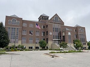
Ottawa County Courthouse in Grand Haven
|
||
|
||

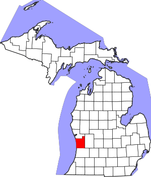
Location within the U.S. state of Michigan
|
||
 Michigan's location within the U.S. |
||
| Country | ||
| State | ||
| Founded | 1831 (authorized) 1837 (organized) |
|
| Named for | Ottawa Nation | |
| Seat | Grand Haven | |
| Largest city | Holland | |
| Area | ||
| • Total | 1,631 sq mi (4,220 km2) | |
| • Land | 563 sq mi (1,460 km2) | |
| • Water | 1,068 sq mi (2,770 km2) 65%% | |
| Population | ||
| • Estimate
(2022)
|
300,873 | |
| • Density | 526/sq mi (203/km2) | |
| Time zone | UTC−5 (Eastern) | |
| • Summer (DST) | UTC−4 (EDT) | |
| Area code | 616 | |
| Congressional districts | 2nd, 3rd, 4th | |
Ottawa County (pronounced OT-uh-wuh) is a county in the state of Michigan. A county is like a smaller region within a state. In 2020, about 296,200 people lived here. The main town, or county seat, is Grand Haven.
The county is named after the Ottawa Nation, a Native American tribe. It was officially created in 1831 and started to be organized in 1837. Ottawa County is part of the larger Grand Rapids area. Many people in the county have Dutch family backgrounds.
Contents
History of Ottawa County
For hundreds of years before European settlers arrived, the Potawatomi and Ottawa Native American people lived in this area. The Grand River was a very important waterway. It was used for trade and travel deep into Michigan. We know a lot about the Native American presence in Ottawa County from old items found at places like the Battle Point Site. These items help us understand their way of life.
European-American settlement began with French fur traders. A trading post called Gabagouache was set up by Madeline La Framboise and her husband Joseph. They traded animal furs with Native Americans.
The first person to settle permanently in the county was a minister named William Montague Ferry. He came to Grand Haven in 1834. Grand Haven quickly became a busy port for ships and trade. William Montague Ferry is often called the "father" of Ottawa County because of his important role.
In 1847, many Dutch settlers started to arrive. They were led by Albertus van Raalte. These Dutch settlers moved into the area around what is now the city of Holland. This land was already home to many Odawa (Ottawa) people and the Old Wing Mission. Within a few years, the new Dutch settlers took over the land. This caused the Ottawa people and the Old Wing Mission to move away.
Geography of Ottawa County
Ottawa County covers a total area of about 1,631 square miles. Most of this area, about 1,068 square miles (65%), is water. The land area is about 563 square miles.
Bodies of Water
Ottawa County has many important rivers and lakes:
- Bass River
- Black Lake (partially)
- Grand River
- Lake Macatawa
- Lake Michigan
- Macatawa River
- Pigeon River
- Spring Lake
Neighboring Counties
Ottawa County shares borders with other counties: By land
- Allegan County – to the south
- Kent County – to the east
- Muskegon County – to the north
By water
- Milwaukee County, Wisconsin – to the northwest
- Racine County, Wisconsin – to the southwest
Main Roads
Several major highways run through Ottawa County, connecting different towns and cities:
 A-37
A-37 B-31
B-31 B-35
B-35 B-72
B-72 BL I-196
 I-196
I-196 I-96
I-96- M-104
 M-11
M-11- M-121
- M-231
 M-45
M-45 M-6
M-6 US 31
US 31
People of Ottawa County
| Historical population | |||
|---|---|---|---|
| Census | Pop. | %± | |
| 1840 | 208 | — | |
| 1850 | 5,587 | 2,586.1% | |
| 1860 | 13,215 | 136.5% | |
| 1870 | 26,651 | 101.7% | |
| 1880 | 33,126 | 24.3% | |
| 1890 | 35,358 | 6.7% | |
| 1900 | 39,667 | 12.2% | |
| 1910 | 45,301 | 14.2% | |
| 1920 | 47,660 | 5.2% | |
| 1930 | 54,858 | 15.1% | |
| 1940 | 59,660 | 8.8% | |
| 1950 | 73,751 | 23.6% | |
| 1960 | 98,719 | 33.9% | |
| 1970 | 128,181 | 29.8% | |
| 1980 | 157,174 | 22.6% | |
| 1990 | 187,768 | 19.5% | |
| 2000 | 238,314 | 26.9% | |
| 2010 | 263,801 | 10.7% | |
| 2020 | 296,200 | 12.3% | |
| 2023 (est.) | 303,372 | 15.0% | |
| sources 1840-2022 | |||
In 2020, there were 296,203 people living in Ottawa County. Most people were White (82.9%). Other groups included Black or African American (2.1%), Asian (2.9%), Native American (0.6%), and people of two or more races (2.2%). About 10.5% of the population was Hispanic or Latino.
Many people in Ottawa County have family roots from different countries. In 2010, about 31% of people had Dutch ancestry. Other common backgrounds included German (14.2%), English (5.8%), and Irish (5.7%).
During the summer, many people come to Ottawa County for vacations. Areas like Port Sheldon Township have many lakefront homes. These are popular summer spots for people from larger cities like Grand Rapids, Detroit, and Chicago.
Ottawa County is known for being a healthy place to live. The Robert Wood Johnson Foundation has ranked it as Michigan's second-healthiest county.
Religions in Ottawa County
Many different religious groups have churches and followers in Ottawa County:
- The Catholic Church has 11 churches and about 24,700 members.
- The Christian Reformed Church in North America has 67 churches and about 33,700 members.
- The Church of Jesus Christ of Latter-day Saints has two meetinghouses.
- The Protestant Reformed Churches have about 10 large churches.
- The Reformed Church in America has 47 churches and about 33,300 members.
Communities in Ottawa County
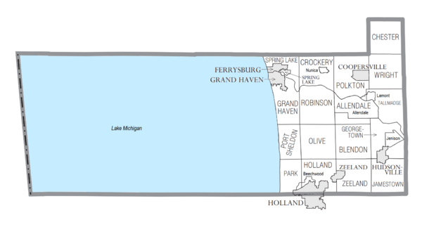
Ottawa County has several cities, a village, and many townships and smaller communities.
Cities
- Coopersville
- Ferrysburg
- Grand Haven (This is the county seat)
- Holland (partially in this county)
- Hudsonville
- Zeeland
Village
- Spring Lake
Charter Townships
- Allendale Charter Township
- Georgetown Charter Township
- Grand Haven Charter Township
- Holland Charter Township
- Jamestown Charter Township
- Polkton Charter Township
- Tallmadge Charter Township
- Zeeland Charter Township
Civil Townships
- Blendon Township
- Chester Township
- Crockery Township
- Olive Township
- Park Township
- Port Sheldon Township
- Robinson Township
- Spring Lake Township
- Wright Township
Census-Designated Places
These are areas that are not officially cities or villages but are recognized for census purposes:
Other Smaller Communities
These are smaller, unincorporated places within the county:
- Agnew
- Bauer
- Beaverdam
- Borculo
- Clark Corners
- Conklin
- Crisp
- Dennison
- Drenthe
- Eastmanville
- Forest Grove
- Forest Grove Station
- Gitchel
- Grand Valley
- Harlem
- Harrisburg
- Herrington
- Jamestown
- Macatawa (partial)
- Marne
- New Holland
- Noordeloos
- North Blendon
- Oaklawn Beechwood
- Olive Center
- Ottawa Center
- Pearline
- Pine Creek
- Port Sheldon
- Reno
- Robinson
- Rosy Mound
- Rusk
- Snug Harbor
- South Blendon
- Tallmadge
- Tasmas Corners
- Virginia Park
- Vriesland
- Waverly
- West Olive
- Wright
- Zutphen
See also
 In Spanish: Condado de Ottawa (Míchigan) para niños
 | William M. Jackson |
 | Juan E. Gilbert |
 | Neil deGrasse Tyson |


