Pigeon River (Ottawa County, Michigan) facts for kids
Quick facts for kids Pigeon River |
|
|---|---|

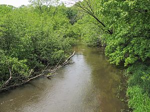
The Pigeon River in Hemlock Crossing Park in Port Sheldon Township
|
|

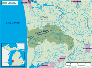
A map of the Pigeon River and its watershed.
|
|
| Country | United States |
| State | Michigan |
| County | Ottawa |
| Townships | Olive, Port Sheldon |
| Physical characteristics | |
| Main source | Olive Township 625 ft (191 m) 42°55′09″N 86°02′41″W / 42.9191895°N 86.044766°W |
| River mouth | Lake Michigan Port Sheldon Township 581 ft (177 m) 42°54′04″N 86°12′55″W / 42.9011315°N 86.2153253°W |
| Length | 12.9 miles (20.8 km) |
| Basin features | |
| Progression | Lake Michigan—Lake Huron—St. Clair—Lake St. Clair—Detroit—Lake Erie—Niagara—Lake Ontario—St. Lawrence—Atlantic Ocean |
| Basin size | 61.7 sq mi (160 km2) |
| Tributaries |
|
| Waterbodies | Pigeon Lake |
| Hydrologic Unit Codes | 040500020302, 040500020303 (USGS) |
The Pigeon River is a small river in Michigan, USA. It flows into Lake Michigan on the western side of the Lower Peninsula. This river is about 12.9 miles (20.8 km) long. It helps drain an area of 61.7 square miles (160 km2) of land. This area is mostly rural and sits between the cities of Holland and Grand Haven. The Pigeon River is part of a much larger water system. Its waters eventually reach the Atlantic Ocean through the Great Lakes and the St. Lawrence River.
| Top - 0-9 A B C D E F G H I J K L M N O P Q R S T U V W X Y Z |
Where the Pigeon River Flows
The Pigeon River and all the land it drains are located entirely within Ottawa County. The river starts from farm drainage ditches in Olive Township. It then flows generally towards the west and southwest.
The river passes through a place called Pigeon Lake. This is the only lake that is part of the river's system. After leaving Pigeon Lake, the river flows into Lake Michigan. This happens in Port Sheldon Township. This spot is about 9.5 miles (15.3 km) northwest of Holland and 11.3 miles (18.2 km) south of Grand Haven.
Parks Along the River
There are two public parks run by the county along the lower part of the Pigeon River. These parks are called Pigeon Creek Park and Hemlock Crossing. They offer great places for people to enjoy nature.
Fish in the River
Since 2003, the Michigan Department of Natural Resources has been adding brown trout to the Pigeon River every year. This helps keep the fish population healthy and provides opportunities for fishing.
Understanding the Pigeon River's Watershed
A watershed is an area of land where all the water drains into a single river or lake. The Pigeon River watershed covers parts of seven different townships in Ottawa County.
Here's a look at how much of each township is part of the watershed:
| Township | Area in Watershed | Percentage of Watershed |
|---|---|---|
| Blendon | 13.3 square miles (34 km2) | 20.5% |
| Grand Haven | 1 square mile (2.6 km2) | 1.5% |
| Olive | 24.2 square miles (63 km2) | 37.4% |
| Park | 1.2 square miles (3.1 km2) | 1.9% |
| Port Sheldon | 17.9 square miles (46 km2) | 27.7% |
| Robinson | 6.8 square miles (18 km2) | 10.5% |
| Zeeland | 0.3 square miles (0.78 km2) | 0.5% |
Changes in Land Use Over Time
Long ago, most of the Pigeon River watershed was covered by thick forests and wetlands. About 75% of the area was a black ash swamp. But by the 1920s, much of this land was cleared for farming. People cut down trees and drained the wet areas to create farmland.
In the 1940s, some parts of the watershed were replanted with trees. This was done to help stop wind from eroding the soil. A study in 1997 found that about half of the land in the watershed was used for farming. This farming included growing plants for nurseries, Christmas trees, blueberries, and other vegetables. Farmers also raised turkeys, chickens for eggs, beef and dairy cattle, and hogs.
Here's how the land was used in the watershed in 1992:
| Land Use | Percentage | Area |
|---|---|---|
| Agriculture (Farming) | 49% | 31.7 square miles (82 km2) |
| Forest (Woods) | 36% | 23.3 square miles (60 km2) |
| Rural Residential (Homes in the Country) | 5% | 3.2 square miles (8.3 km2) |
| Wetland (Swamps and Marshes) | 1% | 0.6 square miles (1.6 km2) |
| Other Uses | 9% | 5.8 square miles (15 km2) |
Smaller Streams Feeding the Pigeon River
Many smaller streams and drains flow into the Pigeon River, adding to its water. These are called tributaries. The National Hydrography Dataset helps identify these streams.
Here are some of the named streams that are part of the Pigeon River watershed:
| Number | Name | Flows Into | Length |
|---|---|---|---|
| 1 | Ten Hagen Creek | Pigeon River | 5.5 miles (8.9 km) |
| 2 | Sawyer Creek | Pigeon River | 1.8 miles (2.9 km) |
| 3 | Owens and Sawyer Drain | unnamed tributary of Sawyer Creek | 1.8 miles (2.9 km) |
| 4 | Walters Drain | Pigeon River | 2.7 miles (4.3 km) |
| 5 | Blendon and Olive Drain | Sycamore Creek | 2.3 miles (3.7 km) |
 | Claudette Colvin |
 | Myrlie Evers-Williams |
 | Alberta Odell Jones |

