
Grand River (Michigan) facts for kids
Quick facts for kids Grand River |
|
|---|---|

A map of the Grand River
|
|
| Physical characteristics | |
| Main source | Somerset Township, Hillsdale County, Michigan 42°05′12″N 84°25′21″W / 42.0867°N 84.42245°W |
| River mouth | Grand Haven, Michigan 43°03′30″N 86°15′03″W / 43.05835°N 86.25088°W |
| Length | 252 miles (406 km) |
| Basin features | |
| Basin size | 5,572sq.mi. |
The Grand River is the longest river in Michigan, United States. It flows for about 252 miles (406 km) across the southern part of Michigan. It starts in Hillsdale County and ends in Lake Michigan at Grand Haven.
Long ago, Native Americans living near the river called it O-wash-ta-nong. This name meant "Far-away-water" because of how long the river is. The city of Grand Rapids got its name from the "Grand Rapids" in the river. These were fast-flowing, rocky parts of the river. However, dams built since 1835 have covered these rapids, so they are no longer visible.
Contents
Where the Grand River Flows

The Grand River begins from natural springs in Somerset Township. It then flows through many counties like Jackson, Ingham, Eaton, and Kent. Finally, it empties into Lake Michigan.
The river passes through several cities and towns. These include Jackson, Lansing, Grand Ledge, Ionia, Grand Rapids, and Grand Haven.
River Facts and Features
The Grand River is one of the main rivers that flow into Lake Michigan. Its water eventually reaches the Atlantic Ocean through the St. Lawrence River. The river drops from about 1,260 feet (384 meters) at its start to 577 feet (176 meters) at Lake Michigan. On average, it releases about 3,800 cubic feet (107.5 cubic meters) of water per second.
The Grand River's Watershed
A watershed is an area of land where all the water drains into a single river or lake. The Grand River's watershed is the second largest in Michigan. It covers about 5,572 square miles (14,431 km²). This area includes 18 counties and many smaller towns. The land in the watershed is mostly flat and has many swamps and lakes.
The Grand River has several smaller rivers that flow into it. These are called tributaries. Some of the main tributaries include the Red Cedar River, Maple River, Flat River, and Thornapple River.
Dams on the River
There are fourteen dams on the main part of the Grand River. Many more dams (around 218) were built on its smaller tributary rivers. These dams help control water flow and can be used to create electricity. However, they can also divide the river's natural environment.
Some of the dams on the main Grand River include:
- Grand River (6th Street)
- Grand Ledge
- Portland
- North Lansing
- Webber (hydroelectric)
- Moore's Park (hydroelectric)
- Smithville (hydroelectric)
- Crystal Lake
- Mirror Lake
River Life
The Grand River is home to many types of fish. For much of its length, it is known as a great place for trout and salmon. These fish are popular for fishing and are an important part of the river's ecosystem.
History of the Grand River
About 11,000 years ago, as the last ice age ended, the Grand River helped drain melting ice from Michigan.
Around 2,000 years ago, a group of Native Americans called the Hopewell Indians lived along the Grand River. You can still see their ancient burial mounds near Grandville. Later, by the late 1600s, the Ottawa people built villages along the river where Grand Rapids is today. For these early people, and for later explorers and traders, the river was a very important way to travel and trade.
The river also played a role in land agreements. In 1821, Native American tribes like the Ottawa, Ojibwe, and Potawatomi agreed to give land south of the Grand River to the United States.
Lumbering and Logjams
In the 1800s, the Grand River was very important for Michigan's lumber industry. Logs from the state's huge pine and oak forests were floated down the river to sawmills. After the Civil War, many soldiers became lumberjacks. They would cut logs and guide them down the river using special tools. These men wore bright red flannel and spiked boots to help them walk on the floating logs.
In 1883, heavy rains caused the river to flood. This flooding was so bad that it broke open the "booms." Booms were special enclosures used to hold and sort logs. Millions of logs escaped and flowed freely down the river. They got stuck in bends and against bridges, creating huge logjams. One logjam stretched for 47 miles!
Grand River Avenue (or Grand River Road) was an early road built in Michigan. It connected the Grand River to downtown Detroit. This road, along with the river itself, was a key route between Chicago and Detroit.
Bringing Back the Rapids
The city of Grand Rapids was founded in 1826 because of the mile-long rapids there. However, these rapids disappeared after dams were built in the 1800s and early 1900s. Now, a group called Grand Rapids Whitewater is working to bring back the rapids. Their plan involves removing some dams to restore the river's natural flow and drop in elevation. This project aims to make the river more natural and enjoyable for everyone.
Fun Places Along the River
The Grand River is home to two campuses of Grand Valley State University. The main campus in Allendale and the Pew Grand Rapids campus are both located along the river. The university's rowing team also practices on the Grand River.
Coast Guard Station Grand Haven is located near where the river meets Lake Michigan. This station is why Grand Haven is known as "Coast Guard City USA."
Parks and Recreation
- Millennium Park (Grand Rapids) is the largest park in western Michigan. It's even bigger than Central Park in New York City!
Bridges Over the Grand River
Many bridges cross the Grand River along its 250-mile path. Most of these bridges are found in cities and towns. There are also many county road and state highway bridges in less populated areas.
Images
-
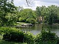
Convergence of the Grand and Red Cedar Rivers in downtown Lansing
-

The Grand River's North Lansing dam, near downtown Lansing
-

The Grand River through downtown Grand Rapids
-
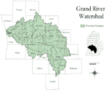
The Grand River Watershed
.jpg)


