Hillsdale County, Michigan facts for kids
Quick facts for kids
Hillsdale County
|
|
|---|---|

|
|

Location within the U.S. state of Michigan
|
|
 Michigan's location within the U.S. |
|
| Country | |
| State | |
| Founded | 1835 |
| Seat | Hillsdale |
| Largest city | Hillsdale |
| Area | |
| • Total | 607 sq mi (1,570 km2) |
| • Land | 598 sq mi (1,550 km2) |
| • Water | 8.9 sq mi (23 km2) 1.5%% |
| Population
(2020)
|
|
| • Total | 45,746 |
| • Estimate
(2023)
|
45,587 |
| • Density | 75.36/sq mi (29.098/km2) |
| Time zone | UTC−5 (Eastern) |
| • Summer (DST) | UTC−4 (EDT) |
| Congressional district | 5th |
| Website | https://www.co.hillsdale.mi.us/ |
Hillsdale County is a special area in the state of Michigan, USA. It's called a county. In 2020, about 45,746 people lived here. The main town, or county seat, is Hillsdale.
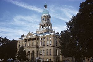
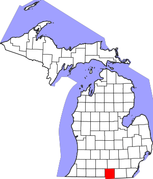
Hillsdale County is unique because it's the only county in Michigan that touches both Indiana and Ohio. It also has the southernmost point in Michigan. The beautiful Hillsdale County Courthouse was designed by a famous architect named Claire Allen.
Contents
History of Hillsdale County
Hillsdale County got its name from its rolling hills and varied land. It was officially created by the Michigan government in 1829. Six years later, in 1835, it became an organized county.
Early Settlers and Their Impact
Many of the first people to settle in Hillsdale County came from New England. These "Yankees" were often descendants of English Puritans who moved to America in the 1600s. They traveled to the Northwest Territory in the early 1800s. Many used the new Erie Canal to get there.
These settlers cared a lot about education. They built many schools in the area. They were also strong supporters of ending slavery.
Geography and Nature
Hillsdale County covers about 607 square miles. Most of this area, about 598 square miles, is land. The rest, about 8.9 square miles, is water.
As mentioned, Hillsdale is the only county in Michigan that shares a land border with two other states: Ohio and Indiana. Two important rivers, the St. Joseph River (Lake Michigan) and the St. Joseph River (Maumee River), start in Hillsdale County.
Local Parks to Explore
Hillsdale County has some great parks for outdoor fun:
- McCourtie Park
- Slayton Arboretum
Neighboring Counties
Hillsdale County is surrounded by several other counties:
- Jackson County (to the northeast)
- Calhoun County (to the northwest)
- Lenawee County (to the east)
- Branch County (to the west)
- Fulton County, Ohio (to the southeast)
- Williams County, Ohio (to the south)
- Steuben County, Indiana (to the southwest)
Climate and Weather
Hillsdale County experiences all four seasons. Summers are warm, and winters are cold.
Temperature and Rainfall
- July is usually the warmest month, with an average high temperature of about 82°F (28°C).
- January is the coldest, with an average high of about 29°F (-2°C).
- June is the wettest month, getting about 4.29 inches (109 mm) of rain on average.
| Climate data for Hillsdale, Michigan | |||||||||||||
|---|---|---|---|---|---|---|---|---|---|---|---|---|---|
| Month | Jan | Feb | Mar | Apr | May | Jun | Jul | Aug | Sep | Oct | Nov | Dec | Year |
| Mean daily maximum °F (°C) | 29 (−2) |
33 (1) |
43 (6) |
56 (13) |
68 (20) |
78 (26) |
82 (28) |
80 (27) |
72 (22) |
60 (16) |
46 (8) |
34 (1) |
57 (14) |
| Mean daily minimum °F (°C) | 13 (−11) |
14 (−10) |
24 (−4) |
35 (2) |
45 (7) |
55 (13) |
59 (15) |
57 (14) |
49 (9) |
38 (3) |
29 (−2) |
19 (−7) |
36 (2) |
| Average precipitation inches (mm) | 2.10 (53) |
1.82 (46) |
2.77 (70) |
3.39 (86) |
3.82 (97) |
4.29 (109) |
3.54 (90) |
3.70 (94) |
3.71 (94) |
2.82 (72) |
3.07 (78) |
2.66 (68) |
37.69 (957) |
| Source: weather.com | |||||||||||||
Population and People
The number of people living in Hillsdale County has changed over the years.
| Historical population | |||
|---|---|---|---|
| Census | Pop. | %± | |
| 1840 | 7,240 | — | |
| 1850 | 16,159 | 123.2% | |
| 1860 | 25,675 | 58.9% | |
| 1870 | 31,684 | 23.4% | |
| 1880 | 32,723 | 3.3% | |
| 1890 | 30,660 | −6.3% | |
| 1900 | 29,865 | −2.6% | |
| 1910 | 29,673 | −0.6% | |
| 1920 | 28,161 | −5.1% | |
| 1930 | 27,417 | −2.6% | |
| 1940 | 29,092 | 6.1% | |
| 1950 | 31,916 | 9.7% | |
| 1960 | 34,742 | 8.9% | |
| 1970 | 37,171 | 7.0% | |
| 1980 | 42,071 | 13.2% | |
| 1990 | 43,431 | 3.2% | |
| 2000 | 46,527 | 7.1% | |
| 2010 | 46,688 | 0.3% | |
| 2020 | 45,746 | −2.0% | |
| 2023 (est.) | 45,587 | −2.4% | |
| US Decennial Census 1790-1960 1900-1990 1990-2000 2010-2018 |
|||
In 2000, there were 46,527 people living in the county. Most people were White (97.56%). A small number were Black or African American (0.43%), Native American (0.35%), or Asian (0.33%). About 1.20% of the population was Hispanic or Latino.
Many people in Hillsdale County have German (28.4%), English (28.2%), or Irish (9.3%) family backgrounds. Most people (97.0%) speak English as their first language.
The average age in the county in 2000 was 36 years old. About 26.30% of the population was under 18 years old.
Getting Around: Transportation
Hillsdale County has several important roads and other ways to travel.
Main Roads and Highways
 US 12: This highway goes east to west across the county for about 23 miles. It's the southernmost US Highway in Michigan that runs east and west.
 US 127: This road runs north to south along part of the county's eastern edge. It's also called Meridian Road.
 M-34: This highway starts at the eastern border and goes west until it meets M-99. It's also known as Hudson Road.
 M-49: This north-south highway starts at the Ohio border and crosses M-99 in the northwest part of the county.
 M-99: This highway goes north to south for about 30 miles. It's also known as Carleton Road, named after the poet Will Carleton.
Air Travel
The Hillsdale Municipal Airport (KJYM) opened in 1963. It has a long paved runway for planes to land and take off. It helps people and businesses travel to and from Hillsdale County.
Walking and Biking Trails
The 4,000-mile National Scenic North Country Trail passes through Hillsdale County. This trail is great for hiking and enjoying nature.
Communities in Hillsdale County
Hillsdale County is made up of several different types of communities.
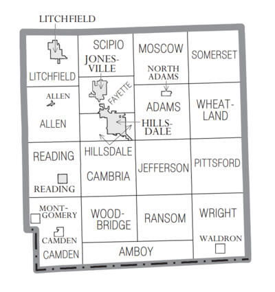
Cities
- Hillsdale (This is the main town, or county seat)
- Jonesville
- Litchfield
- Reading
Villages
Townships
These are smaller areas of land that include rural areas and sometimes smaller communities:
- Adams Township
- Allen Township
- Amboy Township
- Cambria Township
- Camden Township
- Fayette Township
- Hillsdale Township
- Jefferson Township
- Litchfield Township
- Moscow Township
- Pittsford Township
- Ransom Township
- Reading Township
- Scipio Township
- Somerset Township
- Wheatland Township
- Woodbridge Township
- Wright Township
Smaller Unincorporated Communities
These are small places that are not officially cities or villages:
- Amboy Center
- Austin
- Bankers
- Betzer
- Cambria
- Church's Corners
- Frontier
- Jerome
- Lake LeAnn
- Locust Corners
- Moscow
- Mosherville
- Osseo
- Pittsford
- Prattville
- Ransom
- Somerset
- Somerset Center
Notable People from Hillsdale County
Many interesting people have come from Hillsdale County:
- Moses Allen: He was the first settler in the area and fought in the War of 1812.
- Frederick Wilhelm Stock: He started a large flour milling business called F. W. Stock & Sons.
- Oscar F. Avery (1841–1924): A lawyer and state senator in Illinois, born in Allen Township.
- Don A. Jones (1912–2000): An admiral and civil engineer who led important US government agencies. He was born in Waldron.
- Penny Neer: An athlete who competed in the Olympics.
See also
 In Spanish: Condado de Hillsdale para niños
 | Lonnie Johnson |
 | Granville Woods |
 | Lewis Howard Latimer |
 | James West |


