Calhoun County, Michigan facts for kids
Quick facts for kids
Calhoun County
|
|
|---|---|

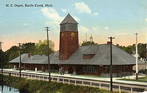
Post Card. Michigan Central Depot in Battle Creek.
|
|

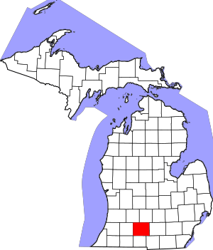
Location within the U.S. state of Michigan
|
|
 Michigan's location within the U.S. |
|
| Country | |
| State | |
| Founded | established 1829 organized 1833 |
| Named for | John C. Calhoun |
| Seat | Marshall |
| Largest city | Battle Creek |
| Area | |
| • Total | 718 sq mi (1,860 km2) |
| • Land | 706 sq mi (1,830 km2) |
| • Water | 12 sq mi (30 km2) 1.7% |
| Population
(2020)
|
|
| • Total | 134,310 |
| • Density | 193/sq mi (75/km2) |
| Congressional districts | 4th, 5th |
Calhoun County is a place in the state of Michigan, USA. It is a type of local government area called a county. In 2020, about 134,310 people lived here.
The main town where the county government is located is Marshall. The biggest city in the county is Battle Creek.
Calhoun County was created on October 19, 1829. It was named after John C. Calhoun. He was the Vice President at that time. The county government officially started on March 6, 1833.
Contents
Geography
Calhoun County covers a total area of about 718 square miles. Most of this area, 706 square miles, is land. The rest, about 12 square miles, is water.
Rivers and Lakes
Here are some important rivers and lakes in Calhoun County:
Neighboring Counties
Calhoun County shares its borders with these other counties:
- Eaton County - to the north
- Barry County - to the northwest
- Jackson County - to the east
- Kalamazoo County - to the west
- Hillsdale County - to the southeast
- Branch County - to the south
- St. Joseph County - to the southwest
History
In July 2010, a big event happened in Calhoun County. A pipeline carrying oil burst. This caused a large oil spill into Talmadge Creek, which flows into the Kalamazoo River.
This was one of the biggest inland oil spills in U.S. history. It was also one of the most expensive to clean up. The pipeline carried a type of heavy oil from Canada. After the spill, the lighter parts of the oil evaporated. This left the heavier oil to sink in the river.
About 35 miles of the Kalamazoo River were closed for cleanup. The river slowly reopened in June 2012. In 2013, the Environmental Protection Agency (EPA) ordered the company to remove more oil from the riverbed.
People and Families
| Historical population | |||
|---|---|---|---|
| Census | Pop. | %± | |
| 1840 | 10,599 | — | |
| 1850 | 19,162 | 80.8% | |
| 1860 | 29,564 | 54.3% | |
| 1870 | 36,569 | 23.7% | |
| 1880 | 38,452 | 5.1% | |
| 1890 | 43,501 | 13.1% | |
| 1900 | 49,315 | 13.4% | |
| 1910 | 56,638 | 14.8% | |
| 1920 | 72,918 | 28.7% | |
| 1930 | 87,043 | 19.4% | |
| 1940 | 94,206 | 8.2% | |
| 1950 | 120,813 | 28.2% | |
| 1960 | 138,858 | 14.9% | |
| 1970 | 141,963 | 2.2% | |
| 1980 | 141,557 | −0.3% | |
| 1990 | 135,982 | −3.9% | |
| 2000 | 137,985 | 1.5% | |
| 2010 | 136,146 | −1.3% | |
| 2020 | 134,310 | −1.3% | |
| 2023 (est.) | 133,366 | −2.0% | |
| U.S. Decennial Census 1790-1960 1900-1990 1990-2000 2010-2019 |
|||
The 2010 Census showed that Calhoun County had 136,146 people. This was a small decrease from the year 2000.
In 2010, there were about 54,016 households in the county. About 31.2% of these households had children under 18 living there. The average household had 2.44 people.
The population was spread out by age. About 24.2% of people were under 18 years old. The median age in the county was 39 years.
Towns and Villages
Calhoun County has several cities, villages, and other communities.
Cities
- Albion
- Battle Creek
- Marshall (This is the county seat)
- Springfield
Villages
- Athens
- Burlington
- Homer
- Tekonsha
- Union City (part of it is here)
Charter Townships
Census-Designated Places
These are areas that are like towns but not officially incorporated.
- Brownlee Park
- Level Park-Oak Park
Other Communities
Many smaller communities are also part of Calhoun County:
- Albion Landing
- Babcock
- Beadle Lake
- Bedford
- Bentleys Corners
- Ceresco
- Charlotte Landing
- Clarence Center
- Clarendon
- Condit
- Duck Lake
- East Leroy
- Eckford
- Greenfield Park
- Joppa
- Lee Center
- Maplehurst
- Marengo
- Old Mill Gardens
- Orchard Park
- Partello
- Pennfield
- Pine Creek
- Pine Creek Indian Reservation
- Rice Creek
- Sonoma
- Springfield Place
- Stanley Corners
- Sunrise Heights (a neighborhood)
- Verona
- Walnut Point
- Wattles Park
- West Leroy
- Wrights Corners
Townships
These are local government areas that cover rural parts of the county.
- Albion Township
- Athens Township
- Burlington Township
- Clarence Township
- Clarendon Township
- Convis Township
- Eckford Township
- Fredonia Township
- Homer Township
- Lee Township
- Leroy Township
- Marengo Township
- Marshall Township
- Newton Township
- Sheridan Township
- Tekonsha Township
Historical Markers
Calhoun County has 83 special signs called Michigan historical markers. These signs tell about important places and events in the county's past.
See also
 In Spanish: Condado de Calhoun (Míchigan) para niños
 | Misty Copeland |
 | Raven Wilkinson |
 | Debra Austin |
 | Aesha Ash |

