St. Joseph River (Lake Michigan) facts for kids
Quick facts for kids St. Joseph River |
|
|---|---|
|
|
 |
|
| Native name | Sakiwäsipi |
| Other name(s) | La Rivière des Miamis (River of the Miamis) |
| Country | United States |
| State | Michigan, Indiana |
| Physical characteristics | |
| Main source | Baw Beese Lake Hillsdale, Michigan 1,096 ft (334 m) 41°54′18″N 084°36′57″W / 41.90500°N 84.61583°W |
| River mouth | Lake Michigan St. Joseph, Michigan and Benton Harbor, Michigan 581 ft (177 m) 42°06′51″N 086°29′18″W / 42.11417°N 86.48833°W |
| Length | 206 mi (332 km) |
| Basin features | |
| Tributaries |
|
| GNIS ID | 1624891 |
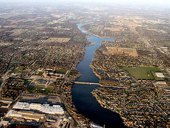
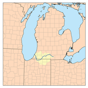
The St. Joseph River, often called the St. Joe, is a 206 miles (332 km) (332 km) long river in the United States. It flows mostly west through southern Michigan and northern Indiana, finally emptying into Lake Michigan. This river is very important for the farms and natural areas it passes through.
For thousands of years, the St. Joe River was a key travel route for Native Americans. Later, it helped early explorers and settlers from New France and the young United States move around. People used canoes to travel between Lake Michigan and the Mississippi River area.
Contents
About the St. Joseph River Area
The St. Joseph River and its surrounding land, called a watershed, covers 4,685 square miles (12,130 km2) (12,134 km²) across 15 counties. These counties are in both Michigan and Indiana. The watershed includes many rivers and streams, totaling 3,742 river miles (6,022 km).
The river flows through or near cities like Kalamazoo, Elkhart, South Bend, and St. Joseph. The main part of the St. Joseph River starts in Hillsdale County, Michigan, from Baw Beese Lake. This lake was named after a Potawatomi Chief, Baw Beese.
How the River Flows
The St. Joseph River takes a winding path, generally heading west. It starts in southern Michigan, then dips into northern Indiana, and finally returns to Michigan.
- From its start, it flows northwest past Hillsdale.
- It then turns southwest, passing Union City and Sherwood.
- At Three Rivers, other rivers like the Rocky and Portage join it.
- The river continues south into northern Indiana, flowing west through Elkhart, Mishawaka, and South Bend.
- In South Bend, it turns sharply north, going back into southwestern Michigan.
- It then flows northwest through Niles and Berrien Springs.
- Finally, it enters Lake Michigan between St. Joseph and Benton Harbor.
Dams on the River
There are 190 dams in the St. Joseph River watershed, with 17 on the main river itself. Most of these dams stop fish from moving freely. Some lower dams have "fish ladders" that help salmon and trout swim upstream. However, these ladders don't work well for many native fish, like sturgeon. Dams are often built where the river flows faster, which are important places for fish to lay their eggs.
River History
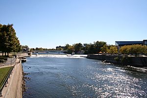
The Miami and Potawatomi tribes called this river Sakiwäsipi, meaning "Outlet River." They lived here for thousands of years, using the river as a vital trade route in the Great Lakes area.
Important Travel Routes
Native Americans created special "portages" (places where canoes were carried over land) to connect the St. Joseph River to other river systems.
- One portage near the river's start in Michigan connected to the St. Joseph River of the Maumee River watershed, which flows into Lake Erie.
- Another key portage was at South Bend. A short carry here led to the Kankakee River, which then connected to the Illinois River and the Mississippi River.
- The Old Sauk Trail, a major east-west Native American path, also crossed the river at Niles.
Early European Explorers
These Native American travel networks helped early Europeans explore the area.
- In 1675, Père Jacques Marquette was guided up the Mississippi River, then the Illinois and Kankakee Rivers, portaging to the St. Joseph River, and finally reaching Lake Michigan.
- On November 1, 1679, René Robert Cavelier, Sieur de La Salle built Fort Miami at the mouth of the river. He named the river La Rivière des Miamis (River of the Miamis).
- La Salle later used the St. Joseph River and Kankakee River portage to travel west towards the Illinois River. In 1680, he became the first European to walk across the Lower Peninsula of Michigan back to the Detroit River and Canada.
- In 1691, the French built Fort St. Joseph at the important crossing of the Old Sauk Trail and the river.
River Use by Settlers
Later, French fur trappers used the river as a canoe route. More European American settlers started moving to the St. Joseph River area after 1829. From the 1830s to 1846, the river was used to transport goods from upstream to a busy port at St. Joseph. From there, goods were loaded onto boats and shipped to Chicago and other places.
In 1893, a large wave called a "seiche" (like a small tsunami) hit the river at St. Joseph and Benton Harbor. This wave, 3 to 5 feet (0.9 to 1.5 m) high, raised the river level by 4 to 5 feet (1.2 to 1.5 m).
South Bend Race Canals
South Bend became a good place for factories because the river could provide hydro-power. Man-made canals, called the East and West Races, were built in 1843 to use the river's power.
- The South Bend Manufacturing Company built the dam and canals.
- Later, the Oliver Chilled Plow Works bought the rights to the West Race canal in 1903. They built a power plant to provide electricity for their buildings.
- Over time, other energy sources became more popular, and the canals were no longer used for factories.
- The East Race canal was filled in around 1954.
- The Oliver power plant was taken down in 1973 to make way for the Century Center.
- The West Race canal still exists today near the Century Center.
East Race Waterway
41°40′34″N 86°14′42″W / 41.676°N 86.245°W
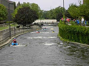
In 1984, the old East Race canal in South Bend was dug out again. It was turned into the East Race Waterway, which was North America's first artificial whitewater course. It opened on June 29, 1984. This waterway can be changed with movable barriers to create different whitewater challenges for kayaking, canoeing, and rafting.
Historic Places Along the River
Several important historical sites are located in the St. Joseph River area:
- Moccasin Bluff and Fort St. Joseph are listed on the U.S. National Register of Historic Places.
- Other sites like Carey Mission, Fort Miami, and Burnett Trading Post are recognized as State Registered Historic Sites in Michigan.
Nature and Wildlife
Before European settlers arrived, the St. Joseph River watershed was covered in thick forests with trees like maple, oak, and elm. There were also large open grasslands called prairies. Animals like elk, white-tailed deer, moose, and bison grazed in these prairies. By 1900, most of the original forests were cut down, and the prairies were turned into farms. Many wetlands were also drained.
Unique Habitats
Even today, the watershed has special natural areas:
- Prairie fens (wetlands fed by groundwater).
- Coastal plain marshes.
- Bogs (wetlands with acidic soil).
- Forests along floodplains.
- Hardwood swamps.
- Moist hardwood forests.
These areas are home to rare plants like prairie dropseed and rosinweed.
Animals of the St. Joe River
The wetlands and floodplain forests are very important for many animals. Nearly half of all migratory birds in Indiana and Michigan use this habitat. It's also home to animals that live there all the time, such as:
- Wild turkey
- Coyote
- Fox
- Beaver
- Mink
- Indiana bat (an endangered species)
- Eastern box turtle
- Rare spotted turtle and northern redbelly snake (both protected in Michigan).
The lower Pigeon River is especially important for the endangered Indiana Bat.
Fish in the River
Since 1969, the Michigan Department of Natural Resources has been adding steelhead trout, Chinook salmon, and coho salmon to the lower part of the river. Fish ladders were built on dams to help these fish swim upstream to lay their eggs. By 1992, salmon and trout could travel 63 miles (101 km) (101 km) from Lake Michigan to the Twin Branch Dam in Indiana. This allowed them to reach cold streams like McCoy Creek to spawn.
However, these fish ladders mainly help salmon and trout. They don't work well for many native fish species that used to migrate up the river. Historically, the river was home to 97 different kinds of fish, including:
- Lake sturgeon
- Bass (smallmouth and largemouth)
- Redhorse (silver, golden, shorthead, river, and greater)
- Walleye
- Lake trout
- Lake whitefish
- Northern pike
- American pickerel
In the past, Potawatomi people and early settlers caught many fish, including huge lake sturgeon that could be up to 12 feet (3.7 m) (3.7 m) long and weigh 300 pounds (140 kg) (136 kg). Sturgeon used to swim as far as Hillsdale County, Michigan. Today, spawning sturgeon rarely get past the dam at Berrien Springs, which means they can't use 155 miles (249 km) (249 km) of their historical spawning grounds.
Protecting the River
In 1994, a group called Friends of the St. Joe River (FotSJR) was started to help clean and restore the river. They created a plan in 2002 to manage the St. Joseph River watershed. The river carries pollutants into Lake Michigan, such as sewage, dirt, and toxic chemicals like mercury and polychlorinated biphenyl (PCB). The river also carries a lot of atrazine, an herbicide used in farming, which can be harmful.
Fun Activities on the St. Joe River
The St. Joseph River is a popular spot for fishing, especially for trout and salmon. This brings a lot of money to local communities in Michigan and Indiana every year.
People who enjoy canoeing can travel the entire length of the main river, as long as they are ready to carry their canoes around dams. Many of the larger streams that flow into the St. Joe also offer great chances for paddling, hiking, hunting, and fishing.
Cities and Towns Along the St. Joseph River
Indiana
Michigan
 | William M. Jackson |
 | Juan E. Gilbert |
 | Neil deGrasse Tyson |


