
Litchfield, Michigan facts for kids
Quick facts for kids
Litchfield, Michigan
|
|
|---|---|
| City of Litchfield | |
.jpg)
Downtown at the intersection of M-49 and M-99
|
|

Location within Hillsdale County
|
|

Litchfield, Michigan
Location in Michigan

Litchfield, Michigan
Location in the United States
|
|
| Country | United States |
| State | Michigan |
| County | Hillsdale |
| Settled | 1834 |
| Platted | 1836 |
| Incorporated | 1877 (village) 1970 (city) |
| Government | |
| • Type | Council–manager |
| Area | |
| • Total | 2.81 sq mi (7.28 km2) |
| • Land | 2.78 sq mi (7.20 km2) |
| • Water | 0.04 sq mi (0.10 km2) |
| Elevation | 1,024 ft (312 m) |
| Population
(2020)
|
|
| • Total | 1,399 |
| • Density | 503.96/sq mi (194.55/km2) |
| Time zone | UTC-5 (Eastern (EST)) |
| • Summer (DST) | UTC-4 (EDT) |
| ZIP code(s) |
49252
|
| Area code(s) | 517 |
| FIPS code | 26-47980 |
| GNIS feature ID | 0630540 |
Litchfield is a small city located in Hillsdale County, in the state of Michigan, USA. In 2020, about 1,399 people lived here.
Even though Litchfield is surrounded by Litchfield Township, the city and the township are managed separately.
Contents
Discovering Litchfield's Past
Litchfield's story began in 1834 when Henry Stevens became the first settler in the area. Just two years later, in 1836, Hervey Smith and his son David planned out the town. This process is called "platting," where they drew maps to divide the land into lots for buildings and streets. They first named the community Smithsville.
The first post office opened on February 3, 1837, and was called Columbus. However, its name changed to Litchfield on August 12, 1837. Henry Stevens suggested this name. He wanted to honor Litchfield, Connecticut, where many of the early settlers had come from. Litchfield officially became a village in 1877. Later, in 1970, it changed its status from a village to a city.
Exploring Litchfield's Geography
Litchfield covers a total area of about 2.81 square miles (7.28 square kilometers). Most of this area, about 2.78 square miles (7.20 square kilometers), is land. A small part, about 0.04 square miles (0.10 square kilometers), is water.
The St. Joseph River flows right through the city, adding to its natural beauty. Also, the North Country Trail, a long hiking trail, passes through the center of Litchfield.
Main Roads in Litchfield
- M-49 (also known as S. Chicago Street) enters Litchfield from the south. It ends when it meets M-99.
- M-99 is another important road that goes through the downtown area of the city.
Litchfield's Population Over Time
| Historical population | |||
|---|---|---|---|
| Census | Pop. | %± | |
| 1880 | 1,029 | — | |
| 1890 | 601 | −41.6% | |
| 1900 | 645 | 7.3% | |
| 1910 | 660 | 2.3% | |
| 1920 | 716 | 8.5% | |
| 1930 | 634 | −11.5% | |
| 1940 | 717 | 13.1% | |
| 1950 | 882 | 23.0% | |
| 1960 | 993 | 12.6% | |
| 1970 | 1,167 | 17.5% | |
| 1980 | 1,353 | 15.9% | |
| 1990 | 1,317 | −2.7% | |
| 2000 | 1,458 | 10.7% | |
| 2010 | 1,369 | −6.1% | |
| 2020 | 1,399 | 2.2% | |
| U.S. Decennial Census | |||
The population of Litchfield has changed over the years. The city had 1,369 people living there in 2010. By 2020, the population had grown slightly to 1,399 residents.
Education in Litchfield
Students in Litchfield attend schools run by the Litchfield Community Schools district. This school district serves the city and parts of the nearby townships.
People from Litchfield
- Marion Babcock Baxter was a lecturer and author. She was born in Litchfield.
Images for kids
-
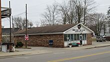
U.S. Post Office in Litchfield -
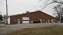
Litchfield Municipal Offices -
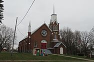
Congregational Church of Litchfield -
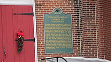
Congregational Church historic marker

.jpg)


See also
 In Spanish: Litchfield para niños
