
Dowagiac River facts for kids
Quick facts for kids Dowagiac River |
|
|---|---|

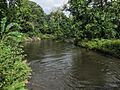
The Dowagiac River in Pokagon Township
|
|
| Country | United States |
| State | Michigan |
| Cities | Dowagiac, Niles |
| Physical characteristics | |
| Main source | Confluence of Dowagiac Drain and Lake of the Woods Drain Berrien County, Michigan 745 ft (227 m) 42°04′39″N 086°01′23″W / 42.07750°N 86.02306°W |
| River mouth | St. Joseph River 636 ft (194 m) 41°50′43″N 086°15′58″W / 41.84528°N 86.26611°W |
| Basin features | |
| Tributaries |
|
The Dowagiac River is a river in Michigan, USA. It flows southwest for about 30.9 miles (49.7 km). This river eventually joins the St. Joseph River, which then flows into Lake Michigan.
Contents
River Environment
The Dowagiac River is special because it's colder than most rivers in southern Michigan. It gets a lot of cold water from underground, called groundwater. This keeps the river cool and flowing steadily, even in summer. In July, the water temperature is usually in the mid-60s Fahrenheit. This is perfect for fish like the brown trout, which isn't originally from here.
Dams and Fish Migration
There were two dams in the river system. The Lower Mill Pond Dam is on Dowagiac Creek. The Barron Lake Road Dam is on McKinzie Creek.
The Pucker Street Dam was the only dam directly on the Dowagiac River. It was located about 3 miles (4.8 km) upstream from where the Dowagiac River meets the St. Joseph River. This dam blocked many fish from swimming upstream. Fish like steelhead trout, Chinook salmon, coho salmon, brown trout, and native fish like smallmouth bass couldn't pass it. This meant they couldn't reach over 159 miles (256 km) of the Dowagiac River and its smaller streams.
In 2013, the Michigan Department of Environmental Quality said the Pucker Street Dam needed to be fixed or removed for safety. It was also seen as the most important dam to remove in the whole St. Joseph River area. Removing it would help with conservation and restoring the river. Work to remove the dam started in September 2019 and finished in 2021.
River Journey
The Dowagiac River watershed covers about 287 square miles (743 km²). A watershed is all the land where water drains into a specific river.
The main part of the Dowagiac River forms when two smaller streams, the Dowagiac Drain and the Lake of the Woods Drain, meet. This happens near the southern edge of Hamilton Township in Berrien County, Michigan. The river then flows into Wayne Township in Cass County.
Where the River Starts
The river's journey begins as the Dowagiac Drain. This drain starts a few miles east of Decatur in Van Buren County, Michigan. As it flows west and south, it is joined by Red Run and then by Lake of the Woods Drain. After these join, it becomes the Dowagiac River.
Along the Way
The river is joined by other streams. Osborn Drain and Silver Creek flow in from the north. North of the city of Dowagiac, the river flows through an area called the Dowagiac Swamp.
Just west of Dowagiac, the river meets its biggest tributary, Dowagiac Creek. Dowagiac Creek starts from a series of lakes, including Saddlebag Lake, Fish Lake, Finch Lake, and Bunker Lake. It flows southwest through LaGrange Lake and then through the city of Dowagiac before joining the main river.
As the Dowagiac River continues flowing south-southwest, it is joined by Peavine Creek, Pokagon Creek, and McKinzie Creek. Finally, it enters Berrien County. Here, it flows into the St. Joseph River just north of Niles.
Tributaries of the Dowagiac River
Here are some of the streams that flow into the Dowagiac River, listed from the mouth (where it joins the St. Joseph River) upstream:
- McKinzie Creek
- Pokagon Creek
- Peavine Creek
- Dowagiac Creek
- LaGrange Lake
- Kelsey Lake
- Bunker Lake
- Finch Lake
- Fish Lake
- Saddlebag Lake
- Silver Creek
- Osborn Drain
- Lake of the Woods Drain
- Red Run
- Dowagiac Drain
Images for kids
-
The Dowagiac River in Pokagon Township
