Berrien County, Michigan facts for kids
Quick facts for kids
Berrien County
|
||
|---|---|---|

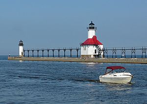
Lighthouse at St. Joseph
|
||
|
||

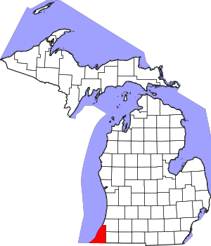
Location within the U.S. state of Michigan
|
||
 Michigan's location within the U.S. |
||
| Country | ||
| State | ||
| Founded | October 29, 1829 (created) 1831 (organized) |
|
| Named for | John M. Berrien | |
| Seat | St. Joseph | |
| Largest city | Niles | |
| Area | ||
| • Total | 1,581 sq mi (4,090 km2) | |
| • Land | 568 sq mi (1,470 km2) | |
| • Water | 1,014 sq mi (2,630 km2) 64%% | |
| Population
(2020)
|
||
| • Total | 154,316 | |
| • Density | 272/sq mi (105/km2) | |
| Time zone | UTC−5 (Eastern) | |
| • Summer (DST) | UTC−4 (EDT) | |
| Congressional districts | 4th, 5th | |
Berrien County is a county in the state of Michigan. It is located in the southwest corner of Michigan's Lower Peninsula. The county is right on the shore of Lake Michigan. It also shares a land border with the state of Indiana.
In 2020, about 154,316 people lived here. The main city and county seat is St. Joseph. Berrien County is part of a larger area called Michiana. This area includes cities like Niles, Benton Harbor, and even South Bend, Indiana.
Contents
History of Berrien County
How Berrien County Got Its Name
Berrien County is one of Michigan's "Cabinet counties." This means it was named after someone who served in the US President's Cabinet. Berrien County was named for John M. Berrien. He was from Georgia. John M. Berrien was the US Attorney General from 1829 to 1831. He worked for President Andrew Jackson.
The county was first created in 1829. It was officially organized in 1831. This happened before Michigan became a state. When Michigan Territory was set up in 1805, the land that is now Berrien County was part of Wayne County.
Early Settlements and Missions
Around 1780, a man named William Burnett started a trading post. It was located at the mouth of the St. Joseph River. This is where the city of St. Joseph is today. The post helped trade with Native Americans and French Canadian settlers. Another trading post was set up by Joseph Bertrand. It was further up the river near present-day Niles Charter Township.
In 1822, a missionary named Isaac McCoy moved his family here. He brought 18 Native American students from Indiana. They opened a religious mission called the Carey Mission. It was for the Potawatomi Indians. This mission was far from other White settlements.
Forming the County and Townships
In 1827, St. Joseph Township was created. It was part of Wayne County. This township included all the land that Native Americans had given up in the 1821 Treaty of Chicago.
The borders of Berrien County were officially drawn on October 29, 1829. At first, it was connected to Cass County for taxes and legal matters. This connection ended in 1831. That's when Berrien County started its own government.
Berrien County began with three main townships:
- Berrien Township
- St. Joseph Township
- Niles Township
Berrien County Today
Today, Berrien County is a popular place for vacations. Many people from the Chicago area come to visit. Cities like New Buffalo and Lakeside are well-known. The area is sometimes called "Harbor Country." It has also been called "the Hamptons of the Midwest."
Geography of Berrien County
Land and Water
Berrien County covers a total area of about 1,581 square miles. A large part of this is water. About 568 square miles is land. The other 1,014 square miles (64%) is water.
The county borders the state of Indiana to the south. To the west, it has a long shoreline along Lake Michigan.
Rivers and Lakes
The St. Joseph River is a very important river here. It flows through the county from Niles to St. Joseph. There it empties into Lake Michigan. Other rivers include the Galien River and the Paw Paw River. Paw Paw Lake is also in the northern part of the county.
Main Roads
Several major highways run through Berrien County.
 I-94 runs along the western side near Lake Michigan. It then turns inland towards St. Joseph and Benton Harbor.
 US 12 goes east-west through the southern part of the county.
 US 31 enters from South Bend, Indiana. It runs north near Niles.
 M-51 goes north through Niles.
Neighboring Areas
Berrien County shares land borders with:
- Van Buren County – to the north and northeast
- Cass County – to the east
- St. Joseph County, Indiana – to the southeast
- LaPorte County, Indiana – to the south
It also borders other counties across Lake Michigan:
- Porter County, Indiana – to the southwest
- Cook County, Illinois – to the west
- Lake County, Illinois – to the northwest
Population of Berrien County
| Historical population | |||
|---|---|---|---|
| Census | Pop. | %± | |
| 1830 | 325 | — | |
| 1840 | 5,011 | 1,441.8% | |
| 1850 | 11,417 | 127.8% | |
| 1860 | 22,378 | 96.0% | |
| 1870 | 35,104 | 56.9% | |
| 1880 | 36,785 | 4.8% | |
| 1890 | 41,285 | 12.2% | |
| 1900 | 49,165 | 19.1% | |
| 1910 | 53,622 | 9.1% | |
| 1920 | 62,653 | 16.8% | |
| 1930 | 81,066 | 29.4% | |
| 1940 | 89,117 | 9.9% | |
| 1950 | 115,702 | 29.8% | |
| 1960 | 149,865 | 29.5% | |
| 1970 | 163,875 | 9.3% | |
| 1980 | 171,276 | 4.5% | |
| 1990 | 161,378 | −5.8% | |
| 2000 | 162,453 | 0.7% | |
| 2010 | 156,813 | −3.5% | |
| 2020 | 154,316 | −1.6% | |
| 2023 (est.) | 152,261 | −2.9% | |
| US Decennial Census 1790-1960 1900-1990 1990-2000 2010-2019 |
|||
In 2010, Berrien County had a population of 156,813 people. This was a small decrease from the year 2000. There were about 63,054 households in the county.
Most people in Berrien County are White (78.3%). About 15.3% are Black or African American. About 4.5% of the population is Hispanic or Latino. The average age of people in the county was 41 years old.
Fun Things to Do in Berrien County
State Parks
County Parks
- Galien River County Park Preserve
- Love Creek County Park
- Madeline Bertrand County Park
- Paw Paw River County Park
- Rocky Gap County Park
- Silver Beach County Park
Other Parks
- Expo Arena – at Berrien County Fairgrounds
- Kiwanis Park – St. Joseph
- Riverview Park – St. Joseph
Resorts and Beaches
- Hagar Park – Hagar Township
- Jean Klock Park - Benton Harbor
- Lion's Park Beach – St. Joseph
- New Buffalo Beach Park – New Buffalo
- Paw Paw Lake
- Rocky Gap Beach Park - Benton Harbor
- Silver Beach - St. Joseph
- Tiscornia Park
- Weko Beach - Bridgman
Golf Courses
- The Golf Club at Harbor Shores - Benton Harbor
- Blossom Trails Golf Club – Benton Harbor
- Brookwood Golf Course - Buchanan
- Lake Michigan Hills Golf Club - Benton Harbor
- Lost Dunes Golf Club - Bridgman
- Milan Creek Golf Club - Baroda
- Orchard Hills Country Club - Buchanan
- Paw Paw Lake Golf Club - Coloma/Watervliet
- Pebblewood Country Club - Bridgman
- Pipestone Creek Golf Course - Eau Claire
- Point O'Woods Golf & Country Club - Benton Harbor
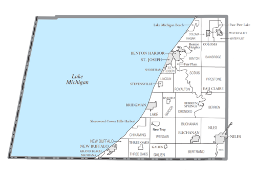
Communities in Berrien County
Cities
- Benton Harbor
- Bridgman
- Buchanan
- Coloma
- New Buffalo
- Niles
- St. Joseph (county seat)
- Watervliet
Villages
Townships
- Bainbridge Township
- Baroda Township
- Benton Charter Township
- Berrien Township
- Bertrand Township
- Chikaming Township
- Coloma Charter Township
- Galien Township
- Hagar Township
- Lake Charter Township
- Lincoln Charter Township
- New Buffalo Township
- Niles Charter Township
- Oronoko Charter Township
- Pipestone Township
- Royalton Township
- Sodus Township
- St. Joseph Charter Township
- Three Oaks Township
- Watervliet Charter Township
- Weesaw Township
Other Communities
Indian Reservation
The Pokagon Band of Potawatomi Indians has a special area called a reservation. Part of this reservation is in the southeastern corner of Berrien County. The tribe also has land in other nearby counties. The main office for the tribe is in Dowagiac. In Berrien County, the reservation land is around the city of Niles. It also covers parts of Bertrand Township and Niles Charter Township along the St. Joseph River.
See also
 In Spanish: Condado de Berrien (Míchigan) para niños
 | Roy Wilkins |
 | John Lewis |
 | Linda Carol Brown |


