Galien, Michigan facts for kids
Quick facts for kids
Galien, Michigan
|
||
|---|---|---|
|
Village
|
||

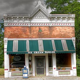
Ice Cream Parlor in Galien
|
||
|
||

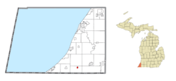
Location within Berrien County
|
||
| Country | United States | |
| State | Michigan | |
| County | Berrien | |
| Township | Galien | |
| Area | ||
| • Total | 0.41 sq mi (1.06 km2) | |
| • Land | 0.41 sq mi (1.06 km2) | |
| • Water | 0.00 sq mi (0.00 km2) | |
| Elevation | 669 ft (204 m) | |
| Population
(2020)
|
||
| • Total | 513 | |
| • Density | 1,248.18/sq mi (482.27/km2) | |
| Time zone | UTC-5 (Eastern (EST)) | |
| • Summer (DST) | UTC-4 (EDT) | |
| ZIP code(s) |
49113
|
|
| Area code(s) | 269 | |
| FIPS code | 26-31300 | |
| GNIS feature ID | 1618901 | |
Galien (pronounced guh-LEEN) is a small village in Berrien County, Michigan. It is located in the United States. In 2020, about 513 people lived there. The village is part of Galien Township.
Contents
History of Galien
The village of Galien was started by George A. Blakeslee. He came to Galien Township in 1853. In 1861, he planned out the village. It officially became a village in 1879.
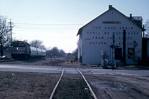
Galien was built along a new railroad line. This line was completed in 1849 and connected New Buffalo to Detroit. George Blakeslee ran a sawmill in the area. He also opened a general store. He bought many acres of land nearby to cut down timber for his sawmill.
For many years, George Blakeslee was very important to Galien. He was the village president and the postmaster. He also served as a justice of the peace and a school board member. Blakeslee Street in Galien is named after him.
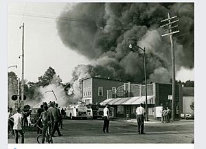
In 1971, two fires caused damage in downtown Galien. On July 21, a fire destroyed a hardware store, a restaurant, and a beauty salon. Three months later, on October 18, another fire badly damaged a nearby IGA supermarket. These fires destroyed a part of the business area.
Geography of Galien
Galien is a small village with a total area of about 0.42 square miles (1.06 square kilometers). All of this area is land. The village is located along U.S. Highway 12. It is also situated near the Galien River. This river is part of the larger Galien River drainage basin.
Population of Galien
| Historical population | |||
|---|---|---|---|
| Census | Pop. | %± | |
| 1880 | 413 | — | |
| 1890 | 492 | 19.1% | |
| 1900 | 440 | −10.6% | |
| 1910 | 405 | −8.0% | |
| 1920 | 460 | 13.6% | |
| 1930 | 488 | 6.1% | |
| 1940 | 567 | 16.2% | |
| 1950 | 610 | 7.6% | |
| 1960 | 750 | 23.0% | |
| 1970 | 691 | −7.9% | |
| 1980 | 692 | 0.1% | |
| 1990 | 596 | −13.9% | |
| 2000 | 593 | −0.5% | |
| 2010 | 549 | −7.4% | |
| 2020 | 513 | −6.6% | |
| U.S. Decennial Census | |||
Galien's Population in 2010
In 2010, there were 549 people living in Galien. There were 227 households in the village. The average age of people in Galien was about 37.6 years old. About 24% of the residents were under 18 years old. About 15.7% were 65 years or older. The population was almost equally split between males and females.
See also
 In Spanish: Galien para niños
 | Georgia Louise Harris Brown |
 | Julian Abele |
 | Norma Merrick Sklarek |
 | William Sidney Pittman |


