
LaPorte County, Indiana facts for kids
Quick facts for kids
LaPorte County
|
|
|---|---|

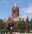
LaPorte County Courthouse in La Porte, Indiana
|
|

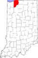
Location in the state of Indiana
|
|

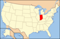
Indiana's location in the U.S.
|
|
| Country | |
| State | |
| Regions | Northwest Indiana and Michiana |
| Metro area | Chicago Metropolitan |
| Established | April 1, 1832 |
| Named for | "The Door" (fr.) |
| County seat | La Porte |
| Largest city | Michigan City (population and total area) |
| Incorporated municipalities |
11 cities and towns
Kingsbury (town)
Kingsford Heights (town) La Porte (city) LaCrosse (town) Long Beach (town) Michiana Shores (town) Michigan City (city) Pottawattamie Park (town) Trail Creek (town) Wanatah (town) Westville (town) |
| Government | |
| • Type | County |
| • Body | Board of Commissioners |
| Area | |
| • County | 613.26 sq mi (1,588.3 km2) |
| • Land | 598.30 sq mi (1,549.6 km2) |
| • Water | 14.96 sq mi (38.7 km2) |
| • Metro | 10,874 sq mi (28,160 km2) |
| Area rank | 2nd largest county in Indiana |
| • Region | 2,726 sq mi (7,060 km2) |
| Elevation
(mean)
|
778 ft (237 m) |
| Highest elevation
– SW Galena Twp
|
957 ft (292 m) |
| Lowest elevation
– at Lake Michigan
|
581 ft (177 m) |
| Population
(2020)
|
|
| • County | 112,417 |
| • Estimate
(2023)
|
111,706 |
| • Rank | 16th largest county in Indiana |
| • Density | 183.3105/sq mi (70.7766/km2) |
| • Metro | 9,618,502 |
| • Region | 819,537 |
| Time zone | UTC−6 (Central) |
| • Summer (DST) | UTC−5 (Central) |
| ZIP Codes |
46340, 46345-46, 46348, 46350,
46352, 46360-61, 46365, 46371, 46382, 46390-91, 46532, 46552, 46554, 46574 |
| Area code | 219 |
| Congressional districts | 1st and 2nd |
| Indiana Senate districts | 5th and 8th |
| Indiana House of Representatives districts | 7th, 9th, 17th and 20th |
| FIPS code | 18-091 |
| GNIS feature ID | 0450507 |
| Interstates | |
| U.S. Routes | |
| State Routes | |
| Airports | La Porte Municipal Michigan City Municipal |
| Waterways | East Arm Little Calumet River Kankakee River Lake Michigan Little Calumet River Trail Creek |
| Amtrak station | Michigan City (closed)
|
| South Shore Line stations | 11th Street – Carroll Avenue Hudson Lake
|
| Public transit | Michigan City Transit |
| Website | www.laportecounty.org |
|
|
LaPorte County is a county in the state of Indiana, USA. In 2020, about 112,417 people lived here. The main city, called the county seat, is La Porte. The biggest city in the county is Michigan City. LaPorte County is part of the Northwest Indiana and Michiana areas, which are close to the big Chicago Metropolitan region. The historic LaPorte County Courthouse in La Porte is a famous building.
Contents
History of LaPorte County
LaPorte County was officially created in 1832. Its name comes from the French words La porte, which mean "the door" or "the port." Early French explorers and travelers gave the area this name. They found a natural opening in the thick forests that once covered this land. This opening was like a doorway to the lands further west.
Early Boundaries and Native American History
From 1832 to 1835, LaPorte County was much larger. Its land stretched all the way to the eastern border of Chicago in Illinois. This area now includes Porter and Lake Counties.
Before European settlers arrived, the land that is now LaPorte County belonged to the Potawatomi Native American nation. In 1838, the United States government moved these Native Americans to Kansas. This journey was very difficult for them and is remembered as the Trail of Death.
European Settlers and County Growth
The first European settlers in LaPorte County mostly came from New England or upstate New York. They were often descendants of English families who settled New England long ago. These settlers helped clear the land, build farms, and create towns. They built churches, government buildings, and set up mail routes.
Over time, more people moved to LaPorte County from other states like New York, Pennsylvania, and Virginia. This mix of people helped the county grow and develop. During the Civil War, LaPorte County played a role in supporting the Union.
The county's borders changed a few times. A part of land north of the Kankakee River first belonged to Starke County. But it was hard for people there to reach the rest of Starke County. So, in 1842, this land was added to LaPorte County. Later, in 1850, more land was added from St. Joseph County to the east. These changes gave LaPorte County the borders it has today.
There is a small debate about how to spell the county's name: "La Porte" or "LaPorte." However, state law officially uses "LaPorte County."
Geography and Natural Features
LaPorte County covers about 613 square miles. Most of this area (about 598 square miles) is land, and a smaller part (about 15 square miles) is water. The highest point in the county is 957 feet above sea level. This spot is in southwestern Galena Township. The lowest point is 581 feet above sea level, along the shore of Lake Michigan.
Neighboring Counties
LaPorte County shares borders with several other counties:
- Berrien County, Michigan (to the North/East)
- St. Joseph County (to the East)
- Starke County (to the South)
- Jasper County (to the Southwest)
- Porter County (to the West)
- Cook County, Illinois (to the Northwest, across Lake Michigan)
Important Natural Areas
Part of the Indiana Dunes National Park is located in LaPorte County. This beautiful park is also in Lake and Porter counties.
Major Transportation Routes
Many important roads and highways pass through LaPorte County, connecting it to other parts of the country.
- Interstates:


- U.S. Routes:
 U.S. Route 6,
  U.S. Route 12,
  U.S. Route 20,
  U.S. Route 30,
  U.S. Route 35,
  U.S. Route 421
 - State Routes:
 State Road 2,
  State Road 4,
  State Road 8,
  State Road 39,
  State Road 104,
  State Road 212
Railroads in the County
Several railway lines run through LaPorte County, helping to transport goods and people. These include:
- Canadian National Railway
- Chesapeake and Indiana Railroad
- Chicago, Fort Wayne and Eastern Railroad
- Chicago South Shore and South Bend Railroad
- CSX Transportation
- Norfolk Southern Railway
- South Shore Line (a train for daily commuters)
Cities, Towns, and Communities
LaPorte County has several cities, towns, and smaller communities where people live.
Cities in LaPorte County
- La Porte (population: 22,053)
- Michigan City (population: 31,479)
Towns in LaPorte County
- Kingsbury (population: 242)
- Kingsford Heights (population: 1,435)
- LaCrosse (population: 551)
- Long Beach (population: 1,179)
- Michiana Shores (population: 313)
- Pottawattamie Park (population: 235)
- Trail Creek (population: 2,052)
- Wanatah (population: 1,048)
- Westville (population: 5,853)
Other Communities
There are also smaller communities in the county, some of which are called "census-designated places" or "unincorporated communities." These include:
- Fish Lake
- Hanna
- Hudson Lake
- Rolling Prairie
- Alida
- Birchim
- Byron
- Door Village
- Duneland Beach
- Hesston
- Holmesville
- Lake Park
- Mill Creek
- Otis
- Pinhook
- Pinola
- Plainfield
- Riverside
- Salem Heights
- Smith
- South Center
- South Wanatah
- Springfield
- Springville
- Stillwell
- Thomaston
- Tracy
- Union Mills
- Waterford
- Wellsboro
- Wilders
- Lakeland
County Townships
LaPorte County has 21 townships, which are local government areas. This is more than any other county in Indiana! Here are some of them with their populations from 2010:
- Cass – 1,833
- Center – 25,075
- Clinton – 1,507
- Coolspring – 14,718
- Dewey – 935
- Galena – 1,899
- Hanna – 965
- Hudson – 1,883
- Johnson – 198
- Kankakee – 4,830
- Lincoln – 1,794
- Michigan – 27,522
- New Durham – 8,664
- Noble – 1,625
- Pleasant – 3,380
- Prairie – 209
- Scipio – 4,570
- Springfield – 4,045
- Union – 2,348
- Washington – 1,357
- Wills – 2,110
Population and People
LaPorte County has grown steadily over the years. In 1840, about 8,184 people lived here. By 2020, the population had grown to 112,417. The county is home to a diverse group of people.
Population Changes Over Time
| Historical population | |||
|---|---|---|---|
| Census | Pop. | %± | |
| 1840 | 8,184 | — | |
| 1850 | 12,145 | 48.4% | |
| 1860 | 22,919 | 88.7% | |
| 1870 | 27,062 | 18.1% | |
| 1880 | 30,985 | 14.5% | |
| 1890 | 34,445 | 11.2% | |
| 1900 | 38,386 | 11.4% | |
| 1910 | 45,797 | 19.3% | |
| 1920 | 50,443 | 10.1% | |
| 1930 | 60,490 | 19.9% | |
| 1940 | 63,660 | 5.2% | |
| 1950 | 76,808 | 20.7% | |
| 1960 | 95,111 | 23.8% | |
| 1970 | 105,342 | 10.8% | |
| 1980 | 108,632 | 3.1% | |
| 1990 | 107,066 | −1.4% | |
| 2000 | 110,106 | 2.8% | |
| 2010 | 111,467 | 1.2% | |
| 2020 | 112,417 | 0.9% | |
| 2023 (est.) | 111,706 | 0.2% | |
| U.S. Decennial Census 1790-1960 1900-1990 1990-2000 2010 |
|||
Diversity in LaPorte County
The county is made up of people from many different backgrounds. In 2020, about 76.46% of the population was White (not Hispanic or Latino). About 10.56% were Black or African American. Other groups include Asian, Native American, and people of mixed races. About 7.10% of the population was Hispanic or Latino (who can be of any race).
Many families live in LaPorte County. In 2010, about 31% of households had children under 18. The average age of people in the county was about 39.6 years old.
Education and Learning
LaPorte County offers many educational opportunities for students of all ages.
K-12 Schools and Districts
Public schools in LaPorte County are managed by seven different school districts. These districts work to provide education from kindergarten through 12th grade. Some of these districts include:
- John Glenn School Corporation
- La Porte Community School Corporation
- Michigan City Area Schools
- New Durham Township Metropolitan School District
- New Prairie United School Corporation
- South Central Community School Corporation
- Tri-Township Consolidated School Corporation
Public Libraries
The county has several public library systems. These libraries offer books, resources, and programs for everyone in the community.
- LaCrosse Public Library
- LaPorte County Public Library (with branches in Coolspring, Fish Lake, Hanna, Kingsford Heights, Rolling Prairie, and Union Mills)
- Michigan City Public Library
- Wanatah Public Library
- Westville-New Durham Township Public Library
Colleges and Universities
For students who want to continue their education after high school, LaPorte County has colleges and universities:
- Ivy Tech Community College
- Purdue University Northwest
Healthcare Services
LaPorte County has hospitals that provide healthcare services to its residents.
- Northwest Health - La Porte, located in La Porte
- Franciscan Health Michigan City, located in Michigan City
Climate and Weather
| Weather chart for La Porte, Indiana | |||||||||||||||||||||||||||||||||||||||||||||||
|---|---|---|---|---|---|---|---|---|---|---|---|---|---|---|---|---|---|---|---|---|---|---|---|---|---|---|---|---|---|---|---|---|---|---|---|---|---|---|---|---|---|---|---|---|---|---|---|
| J | F | M | A | M | J | J | A | S | O | N | D | ||||||||||||||||||||||||||||||||||||
|
1.8
30
12
|
1.7
36
16
|
3
47
27
|
4.1
60
37
|
4.3
71
47
|
4.8
80
58
|
3.9
84
62
|
3.9
81
60
|
3.3
75
51
|
3
63
39
|
3.6
48
30
|
2.7
35
19
|
||||||||||||||||||||||||||||||||||||
| temperatures in °F precipitation totals in inches source: The Weather Channel |
|||||||||||||||||||||||||||||||||||||||||||||||
|
Metric conversion
|
|||||||||||||||||||||||||||||||||||||||||||||||
The weather in LaPorte County changes throughout the year. In January, the average low temperature is about 12°F (about -11°C). In July, the average high temperature is about 84°F (about 29°C). However, temperatures can be much more extreme. The coldest temperature ever recorded was -28°F (-33°C) in January 1977. The hottest was 104°F (40°C) in June 1988. The county also gets a good amount of rain and snow, with the most precipitation usually in June.
Images for kids
-
LaPorte County Courthouse in La Porte, Indiana
-
Location in the state of Indiana
-
Indiana's location in the U.S.
See also
 In Spanish: Condado de LaPorte para niños
