Calumet River facts for kids
Quick facts for kids Calumet River |
|
|---|---|

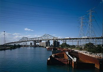
The Calumet River, with the Chicago Skyway traversing it
|
|
| Physical characteristics | |
| Main source | Confluence of the Little Calumet and the Grand Calumet, Chicago 581 ft (177 m) 41°38′38″N 87°33′39″W / 41.6438889°N 87.5608333°W |
| River mouth | Confluence with Lake Michigan, Chicago 574 ft (175 m) 41°43′58″N 87°31′46″W / 41.7327778°N 87.5294444°W |
| Basin features | |
| Progression | Calumet River → Lake Michigan → Great Lakes → Saint Lawrence Seaway → Gulf of Saint Lawrence |
| GNIS ID | 405379 |
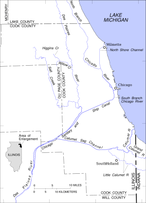
The Calumet River is a group of rivers and canals. They are located between the south side of Chicago, Illinois, and the city of Gary, Indiana. This area is very industrial. Long ago, the Little Calumet River and the Grand Calumet River were connected. The Little Calumet flowed west from Indiana into Illinois. Then it turned east to meet Lake Michigan in Gary.
Contents
About the Calumet River Area
The name "Calumet" comes from a French word. It describes a special Native American ceremonial pipe. This pipe was a sign of peace among the Illiniwek people. It was given to Pere Marquette in 1673.
Before people changed the land, water flowed west from LaPorte County, Indiana. It followed the Little Calumet River. Then it made a sharp turn at Blue Island. From there, it flowed east along the Grand Calumet. It finally reached Lake Michigan near Gary, Indiana. The land here is very flat. This means the river's path and even its direction have changed many times. The flat land also gives the river a very slow current.
Factories and industries started growing in the Calumet River area around the 1870s. By 1890, the western part of the Grand Calumet River was very polluted. Waste came from steel mills, foundries, and food processing plants. More industries spread along the river between 1890 and 1910. This caused even more pollution. Years of this pollution have left the river's bottom highly contaminated today.
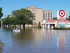
In September 2008, heavy rains caused flooding in parts of Indiana. The Little Calumet River overflowed its banks. It flooded towns like Munster and Highland. In September 2019, a steel mill in Indiana had a chemical spill. This spill went into a part of the Little Calumet River. It caused three Lake Michigan beaches to close for a short time.
Parts of the Calumet River System
The Calumet River
The Calumet River is on the south side of Chicago. It used to just drain Lake Calumet into Lake Michigan. A canal was later dug to connect it to the other Calumet Rivers. This is where the name changes from Grand to Little.
The T.J. O'Brien Lock and Dam was built on the river in 1960. It helps control how water moves between Lake Michigan and the river.
The Grand Calumet River
The Grand Calumet River starts in Miller Beach, Indiana. It flows for about 16.0 miles (25.7 km) through several cities. These include Gary, East Chicago, and Hammond in Indiana. It also flows through Calumet City and Burnham in Illinois. Most of the river's water flows into Lake Michigan. It goes through the Indiana Harbor and Ship Canal. About 1,500 cubic feet (42 m3) of water goes into the lake every second.
Today, much of the river's flow comes from city and factory wastewater. It also gets water from cooling systems and storm drains. Even though pollution has been reduced, some harmful substances still affect the area.
The Little Calumet River

The Little Calumet River originally flowed from New Durham Township, LaPorte County, Indiana. It joined the Grand Calumet and Calumet rivers. However, the Burns Waterway was built in 1926. This split the Little Calumet River into a west and an east arm.
The west arm is now called the Little Calumet River. It flows through or borders many towns. These include Portage, Lake Station, and Gary. It also goes through Munster and Hammond in Indiana. In Illinois, it flows through South Holland, Dolton, and Blue Island. This part of the river is 41 miles (66 km) long.
Since 1926, the Burns Waterway has divided its flow. The part east of Hart Ditch in Munster flows east. It goes to the Burns Waterway and then to Lake Michigan. The part west of Hart Ditch flows west. It goes to the Calumet River and Cal-Sag Channel. The Little Calumet has 109 miles (175 km) of river and smaller streams. It drains an area of 213 square miles (550 km2). Its main smaller streams are Deep River and Salt Creek.
The East Arm Little Calumet River starts in New Durham Township, LaPorte County, Indiana. It flows through Chesterton and Burns Harbor. There it connects to the Port of Indiana-Burns Waterway. This arm is 22 miles (35 km) long. It used to flow west into Illinois. But the Burns Waterway, built in 1926, changed its path. Now its water goes into Lake Michigan.
Until the late 1940s or early 1950s, the Little Calumet River was very polluted. Only carp could live in it. During heavy spring rains, the river often flooded nearby areas.
The Little Calumet River has been part of a big project since 1990. The U.S. Army Corps of Engineers is building a flood control and recreation project. It costs $200 million. The project includes building 22 miles (35 km) of levees and floodwalls. It also adds a control structure at Hart Ditch. Almost 17 miles (27 km) of hiking trails are also being built. Some of the river channel is being moved to help water flow better. Highway bridges are also being changed. A flood warning system is being put in place too.
When finished, this project will protect over 9,500 homes and businesses. It will help towns like Gary, Griffith, Highland, Hammond, and Munster in Indiana. It is expected to prevent almost $11 million in flood damage each year. In September 2008, heavy rain from Hurricane Ike flooded the Little Calumet River. Many homes in Munster and Hammond were damaged. A new levee is now being built in Munster to protect residents from future floods.
The Cal-Sag Channel

The Cal-Sag Channel is a navigation canal in southern Cook County, Illinois. Its name is short for "Calumet-Saganashkee Channel." It connects the Little Calumet River to the Chicago Sanitary and Ship Canal. The channel is 16 miles (26 km) long. It took 11 years to dig, from 1911 to 1922.
The Cal-Sag Channel is used by barges. It was once a busy area for heavy industries in Chicago's southern neighborhoods. As of 2006, it is also used to carry wastewater from southern Cook County. This includes water from the Chicago-area Deep Tunnel Project. This water flows into the Illinois Waterway. The channel is also popular for pleasure boats in the summer.
The western 4.5 miles (7.3 km) of the channel flow through the Palos Hills Forest Preserves. This is a large park area managed by the Forest Preserve District of Cook County.
The Cal-Sag Channel was used for rowing events. This happened during the 1959 Pan American Games.
A new path called the Calumet-Sag Trail is being built. It will be a 26-miles-long (41 km) greenway. It will follow the channel from the Chicago Sanitary and Ship Canal to the Burnham Greenway.
 | Bessie Coleman |
 | Spann Watson |
 | Jill E. Brown |
 | Sherman W. White |


