
Lake Calumet facts for kids
Quick facts for kids Lake Calumet |
|
|---|---|
.jpg)
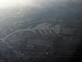
Aerial shot of Lake Calumet
|
|

Lake Calumet
Location in Chicago metropolitan area

Lake Calumet
Location in Illinois

Lake Calumet
Location in the United States
|
|
| Location | Chicago, Illinois |
| Coordinates | 41°40′48″N 87°35′24″W / 41.68000°N 87.59000°W |
| Primary outflows | Des Plaines River |
| Basin countries | United States |
Lake Calumet is the biggest body of water inside the city of Chicago. Long ago, it was a shallow lake formed after glaciers melted. It used to drain into Lake Michigan. But over time, factories and businesses changed it a lot. People dug out some parts (this is called dredging). Other parts were filled in with waste (this is called landfill). Now, like much of Chicago, the lake's water flows into the Des Plaines River. From there, it goes into the huge Mississippi River basin.
The name "Calumet" comes from a French word. French explorers in Canada in the 1600s used it. They used it to describe the special pipes they saw First Nations people using.
Contents
History of Lake Calumet
Early Times and Native Americans
Before the 1800s, Lake Calumet was surrounded by a huge wetland. A wetland is a swampy area. This area was close to the southern tip of Lake Michigan. Like many wetlands, this area was an important home for Native Americans. They lived and settled along the rivers and around the lake. The Field Museum of Natural History has records about these old settlements. These records are based on archeological findings.
Growth of Industry
In 1861, the Lake Calumet region became part of Hyde Park Township. This township was south of what was then the town of Chicago. In the 1880s, the lake's Calumet River became important for shipping. It connected to Lake Michigan. Because of this, the swampy area was quickly filled in. Many factories and businesses were built there. Hyde Park Township grew fast. It became part of Chicago in 1889. Even today, this area has a lot of industry.
Pullman and Steel Mills
The Chicago neighborhood of Pullman was built as a special town. It was a "company town." This meant one company owned all the homes and services. They rented them to workers who built passenger cars for trains. This historic area is now a National Monument. It is located on the west side of Lake Calumet. Over time, steel mills began to appear along the Calumet River. The Illinois Central railroad was also built nearby.
Freeways and Landfills
In the 1950s, part of the old lakebed was used to build a freeway. This road was first called the Calumet Expressway to honor the lake.
Another part of the former wetland, south of the lake, became the Paxton Landfill. This landfill was the final resting place for much of Chicago's household and industrial solid waste. Some of the waste was steel mill slag. Slag is a leftover material from making steel. Other industrial wastes were also dumped there. Later, people found dangerous chemicals in much of this waste. This led to efforts to add parts of the Lake Calumet area to the national Superfund list. The Superfund program helps clean up polluted sites.
In the early 1980s, people suggested Lake Calumet as a place for the Chicago 1992 World's Fair. But this plan was later canceled. In 1989, Mayor Richard M. Daley proposed building the Lake Calumet Airport. This idea also failed within three years.
In 1996, the Calumet Expressway was renamed the Bishop Ford Freeway. This was to honor Bishop Louis Henry Ford, a religious leader in Chicago.
Lake Calumet Today
The remaining parts of Lake Calumet are on the far south side of Chicago. They are east of the Bishop Ford Freeway (Interstate 94). The lake is located between 103rd and 130th streets. It is part of the Port of Chicago, which is a shipping area. You can see a large grain elevator by the lake from the freeway. South of the lake, the freeway passes the Paxton Landfill. You can see pipes there that collect methane and other gases. These gases are made by the landfill.
The lake is officially within Chicago's South Deering community area. Cleanup efforts in the old landfill areas are still happening. This work was ongoing 2010|lc=on.
Lake Calumet's Environment
Special Plants and Birds
The wetlands around Lake Calumet were once the only place where a special plant called Thismia americana was found. This plant was unique to the wet prairie areas here. Because of all the big changes to the Lake Calumet area, this plant is now believed to be extinct.
Even though Lake Calumet has changed a lot since the 1880s, some parts of the area are still wetlands. The area has been named an Important Bird Area of Illinois. It is part of the path that birds use when they fly along Lake Michigan and the rivers.
Superfund Cleanup Efforts
On March 2, 2010, the U.S. Environmental Protection Agency (EPA) added the Lake Calumet Cluster to the Superfund List. This "cluster" is a group of sites around Lake Calumet. Some local areas within this cluster are very dangerous. Workers who dig there must wear special masks and carry their own air or oxygen.
Even with these challenges, planners hope to clean up the less polluted sites. This would allow these areas to be used again for new purposes. The most polluted sites will be covered up. Also, Landfill gas could be collected from the landfills. The methane gas could be filtered and used as energy.
Images for kids
-
An aerial view of Lake Calumet.
