Burnham, Illinois facts for kids
Quick facts for kids
Burnham, Illinois
|
||
|---|---|---|
|
||

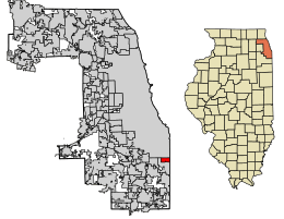
Location of Burnham in Cook County, Illinois.
|
||
| Country | ||
| State | Illinois | |
| County | Cook | |
| Township | Thornton | |
| Incorporated | 1907 | |
| Government | ||
| • Type | Council–manager | |
| Area | ||
| • Total | 1.94 sq mi (5.02 km2) | |
| • Land | 1.85 sq mi (4.80 km2) | |
| • Water | 0.09 sq mi (0.22 km2) 4.62% | |
| Population
(2020)
|
||
| • Total | 4,046 | |
| • Density | 2,181.13/sq mi (842.19/km2) | |
| Standard of living (2007–2011) | ||
| • Per capita income | $18,234 | |
| • Median home value | $143,200 | |
| ZIP code(s) |
60633
|
|
| Area code(s) | 708 | |
| Geocode | 17-09798 | |
| FIPS code | 17-09798 | |
| Website | https://burnham-il.gov | |
Burnham is a small village located in Cook County, Illinois, in the United States. In 2020, about 4,046 people lived there. The village has a Chicago ZIP code (60633). It was named after Telford Burnham, who helped plan the area.
Burnham is divided into two main parts. The western part is around Torrence Avenue, a street that runs north and south. This part of Burnham connects to Chicago by a bridge. The eastern part is near Burnham Avenue, another north-south street. This section ends at Brainard Avenue, where the Hegewisch neighborhood of Chicago begins. When you enter Chicago, Burnham Avenue changes its name to Avenue O.
Contents
History of Burnham
Burnham is very close to Chicago. Because of this, people often discuss whether Chicago should take over Burnham. Some people think Burnham is too small to run itself well. They believe it might be cheaper for people in Burnham if it became part of Chicago.
Geography of Burnham
Burnham is located at 41°38′8″N 87°33′5″W / 41.63556°N 87.55139°W. It covers about 1.94 square miles (5.02 square kilometers). Most of this area is land, about 1.86 square miles (4.80 square kilometers). A small part, about 0.09 square miles (0.22 square kilometers), is water. This water area includes part of Powderhorn Lake. It also includes a nature preserve next to the lake. This preserve is managed by the Cook County Forest Preserve District.
Neighboring Areas
Burnham shares its borders with several other places:
- To the north, it borders Chicago.
- To the south and west, it borders Calumet City.
- To the east, it borders Hammond, Indiana.
Population and People
| Historical population | |||
|---|---|---|---|
| Census | Pop. | %± | |
| 1910 | 328 | — | |
| 1920 | 795 | 142.4% | |
| 1930 | 994 | 25.0% | |
| 1940 | 865 | −13.0% | |
| 1950 | 1,331 | 53.9% | |
| 1960 | 2,478 | 86.2% | |
| 1970 | 3,634 | 46.7% | |
| 1980 | 4,030 | 10.9% | |
| 1990 | 3,916 | −2.8% | |
| 2000 | 4,170 | 6.5% | |
| 2010 | 4,206 | 0.9% | |
| 2020 | 4,046 | −3.8% | |
| U.S. Decennial Census 2010 2020 |
|||
In 2020, Burnham had 4,046 residents living in 1,607 households. The population density was about 2,085 people per square mile.
Who Lives in Burnham?
The people living in Burnham come from many different backgrounds:
- About 60.43% were African American.
- About 16.58% were White.
- About 12.75% were from other races.
- About 9.34% were from two or more races.
- About 25.58% of the population identified as Hispanic or Latino.
About 26.9% of households had children under 18. The average household had about 3.56 people. The average family had about 2.40 people.
Age in Burnham
The median age in Burnham was 38.1 years old.
- About 23.9% of residents were under 18.
- About 13.9% were 65 or older.
Transportation
Pace provides bus services in Burnham. These buses connect the village to many places across the Southland area.
Famous People from Burnham
- Mary Matalin: A well-known political consultant and author.
See also
 In Spanish: Burnham (Illinois) para niños
 | Mary Eliza Mahoney |
 | Susie King Taylor |
 | Ida Gray |
 | Eliza Ann Grier |


