
Cook County, Illinois facts for kids
Quick facts for kids
Cook County
|
|||
|---|---|---|---|
      From top, left to right: Cook County Circuit Court at Daley Center with Chicago Picasso, Frank Lloyd Wright Home and Studio, Forest Preserve District, aerial view of downtown Chicago, aerial view of Evanston, Montrose Avenue Beach in Chicago
|
|||
|
|||

Location within Illinois
|
|||

Illinois' location within the United States
|
|||
| Country | United States | ||
| State | Illinois | ||
| Region | Northern Illinois | ||
| Metro area | Chicago metropolitan area | ||
| Incorporated | January 15, 1831 | ||
| Named for | Daniel Pope Cook | ||
| County seat | Chicago | ||
| Incorporated municipalities |
135 (total)
23 cities, 1 town, 111 villages
(located entirely or partially within county boundaries) |
||
| Government | |||
| • Type | County commission | ||
| • Body | Board of Commissioners | ||
| Area | |||
| • County | 1,635 sq mi (4,230 km2) | ||
| • Land | 945 sq mi (2,450 km2) | ||
| • Water | 690 sq mi (1,800 km2) | ||
| • Metro | 10,874 sq mi (28,160 km2) | ||
| Area rank | 6th largest county in Illinois | ||
| Highest elevation | 950 ft (290 m) | ||
| Lowest elevation | 580 ft (180 m) | ||
| Population
(2020)
|
|||
| • County | 5,275,541 | ||
| • Estimate
(2023)
|
5,087,072 |
||
| • Density | 3,226.6/sq mi (1,245.8/km2) | ||
| GDP | |||
| • County | $485.547 billion (2022) | ||
| Time zone | UTC−6 (Central) | ||
| • Summer (DST) | UTC−5 (Central) | ||
| ZIP Code prefixes |
600xx–608xx
|
||
| Area codes | 847/224, 312/872, 773/872, 708/464 | ||
| FIPS code | 17-031 | ||
| GNIS feature ID | 1784766 | ||
| Congressional districts | 1st, 2nd, 3rd, 4th, 5th, 6th, 7th, 8th, 9th, 10th, 11th | ||
| Website | www.cookcountyil.gov | ||


Cook County is a very important county in the state of Illinois. It has the most people living in it compared to any other county in Illinois. It's also the second most populated county in the entire United States, right after Los Angeles County, California. More than 40 out of every 100 people in Illinois live here!
As of 2020, about 5.2 million people call Cook County home. The main city and "county seat" is Chicago. Chicago is the biggest city in Illinois and the third biggest city in the United States. Cook County is the heart of the Chicago metropolitan area, which is a huge urban region.
Cook County was officially created in 1831. It was named after Daniel Pope Cook, an important early leader in Illinois. The county grew very quickly. In less than 100 years, it went from a small trading village to a place with four million people. This made it as big as cities like Paris during the Great Depression.
There are over 800 local government groups and almost 130 towns and cities in Cook County. Chicago is the largest of these, with about 54% of the county's total population. The county government is managed by the Cook County Board of Commissioners. The president of this board is the main leader.
Cook County is the sixth largest county in Illinois by land area. But if you include its water area, it's the largest county in Illinois. It shares its Lake Michigan shoreline with Lake County. The county has a total area of about 1,635 square miles (4,235 km²). Most of this extra area is water from Lake Michigan.
Because of its location on Lake Michigan and the Chicago Portage, Cook County became a major shipping center. The Illinois and Michigan Canal was built in 1848. This helped make the region a central place for trade across the nation. Chicago is a global port city because of its connection to the Great Lakes and the St. Lawrence Seaway.
Cook County has more people than 28 U.S. states and territories. It also has more people than 11 of the 13 Canadian provinces and territories. It's a very busy and important place!
Contents
History of Cook County
Cook County was formed on January 15, 1831. It was created from Putnam County by a law from the Illinois General Assembly. It was the 54th county in Illinois. The county was named after Daniel Pope Cook. He was one of Illinois's first and youngest important leaders. He was the state's second U.S. representative and its first attorney general. In 1839, DuPage County was created from part of Cook County.
-
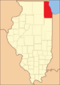
Cook County from 1831 to 1836
-
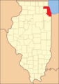
Cook County's current size was formed in 1839 by the creation of DuPage County


The shape of Cook County hasn't changed since DuPage County was formed. But the number of people living here has grown a lot. In 1840, the county had just over 10,000 people. By 2019, it was estimated to have over 5.1 million people! Most of the land in Cook County is now developed, with very little farmland left.
People of Cook County
| Historical population | |||
|---|---|---|---|
| Census | Pop. | %± | |
| 1840 | 10,201 | — | |
| 1850 | 43,385 | 325.3% | |
| 1860 | 144,954 | 234.1% | |
| 1870 | 349,966 | 141.4% | |
| 1880 | 607,524 | 73.6% | |
| 1890 | 1,191,922 | 96.2% | |
| 1900 | 1,838,735 | 54.3% | |
| 1910 | 2,405,233 | 30.8% | |
| 1920 | 3,053,017 | 26.9% | |
| 1930 | 3,982,123 | 30.4% | |
| 1940 | 4,063,342 | 2.0% | |
| 1950 | 4,508,792 | 11.0% | |
| 1960 | 5,129,725 | 13.8% | |
| 1970 | 5,492,369 | 7.1% | |
| 1980 | 5,253,655 | −4.3% | |
| 1990 | 5,105,067 | −2.8% | |
| 2000 | 5,376,741 | 5.3% | |
| 2010 | 5,194,675 | −3.4% | |
| 2020 | 5,275,541 | 1.6% | |
| 2023 (est.) | 5,087,072 | −2.1% | |
| U.S. Decennial Census 1790–1960 1900–1990 1990–2000 2010–2019 |
|||
In 2000, about 30.9% of households in Cook County had children under 18 living there. About 44% were married couples. The average household had 2.68 people.


The median age in the county was 34 years old. This means half the people were younger than 34 and half were older.
The median income for a family in 2000 was about $53,784 per year. The average income per person was about $23,227. About 13.5% of the population lived below the poverty line.
From 1990 to 2000, the county's population grew by 5.3%. It then went down a little (3.4%) between 2000 and 2010. But it grew again by 1.6% between 2010 and 2020.
Who lives in Cook County?
Cook County is a very diverse place with people from many different backgrounds.
| Race / Ethnicity (NH = Non-Hispanic) | Pop 2000 | Pop 2010 | Pop 2020 | % 2000 | % 2010 | % 2020 |
|---|---|---|---|---|---|---|
| White alone (NH) | 2,558,709 | 2,278,358 | 2,135,243 | 47.59% | 43.86% | 40.47% |
| Black or African American alone (NH) | 1,390,448 | 1,265,778 | 1,185,601 | 25.86% | 24.37% | 22.47% |
| Native American or Alaska Native alone (NH) | 6,754 | 6,682 | 5,655 | 0.13% | 0.13% | 0.11% |
| Asian alone (NH) | 257,843 | 318,869 | 408,691 | 4.80% | 6.14% | 7.75% |
| Pacific Islander alone (NH) | 1,543 | 1,043 | 961 | 0.03% | 0.02% | 0.02% |
| Other race alone (NH) | 7,291 | 7,751 | 20,538 | 0.14% | 0.15% | 0.39% |
| Mixed race or Multiracial (NH) | 82,413 | 71,432 | 136,074 | 1.53% | 1.38% | 2.58% |
| Hispanic or Latino (any race) | 1,071,740 | 1,244,762 | 1,382,778 | 19.93% | 23.96% | 26.21% |
| Total | 5,376,741 | 5,194,675 | 5,275,541 | 100.00% | 100.00% | 100.00% |
In 2010, about 55.4% of Cook County's population was White. About 24.8% were African American. Asian Americans made up 6.2% of the population. People of Hispanic or Latino background (who can be of any race) made up 24% of the population.
Cook County has the most Black residents of any county in the United States. Many people in Cook County also speak Spanish or Polish at home.
.svg)
Religions in Cook County
In 2010, the largest religious group in Cook County was Catholics. There were almost 2 million Catholics. Many other Christian groups also live here, like Baptists and Lutherans. There are also many Muslims, with over 200,000 followers. Cook County has a large number of different religious organizations.
Geography and Climate
| Weather chart for Chicago, Illinois | |||||||||||||||||||||||||||||||||||||||||||||||
|---|---|---|---|---|---|---|---|---|---|---|---|---|---|---|---|---|---|---|---|---|---|---|---|---|---|---|---|---|---|---|---|---|---|---|---|---|---|---|---|---|---|---|---|---|---|---|---|
| J | F | M | A | M | J | J | A | S | O | N | D | ||||||||||||||||||||||||||||||||||||
|
2.2
32
18
|
1.8
38
24
|
3
47
32
|
3.7
59
42
|
3.7
70
51
|
4.3
80
61
|
3.7
84
66
|
3.9
83
65
|
3.2
76
57
|
2.7
64
46
|
3.3
49
35
|
2.6
37
24
|
||||||||||||||||||||||||||||||||||||
| temperatures in °F precipitation totals in inches source: The Weather Channel |
|||||||||||||||||||||||||||||||||||||||||||||||
|
Metric conversion
|
|||||||||||||||||||||||||||||||||||||||||||||||
Cook County covers about 1,635 square miles (4,235 km²). About 945 square miles (2,447 km²) is land, and 690 square miles (1,787 km²) is water. Most of this water is part of Lake Michigan. The highest point in the county is about 950 feet (290 meters) high. The lowest point is about 580 feet (177 meters) high, along the Lake Michigan shoreline.
Weather in Cook County
In July, the average high temperature in Chicago is about 84°F (29°C). The average low at night is about 68°F (20°C). In January, the average high is about 31°F (-1°C), and the low is about 18°F (-8°C). Winters can sometimes get above 40°F (4°C). The county gets the most rain in June and the least in February.
Protected Areas
Cook County has some special protected areas:
Transportation in Cook County
Cook County is a major hub for transportation. This means it's a central place where many different ways of travel connect.
Canals and Waterways
The Erie Canal in New York connected the Atlantic Ocean to the Great Lakes in 1821. This made people in Chicago and Cook County realize how useful a canal would be. They wanted to connect the Great Lakes to the Mississippi River. The Illinois and Michigan Canal was finished in 1848. It started in Chicago and went to the Illinois River. This canal helped Chicago and the surrounding areas grow a lot. Water travel was the main way to ship goods back then.
Later, the Chicago Sanitary and Ship Canal was built in 1900. This new canal took over most of the old canal's jobs. It also changed the flow of the Chicago River. Before, the river flowed into Lake Michigan. Now, it flows away from the lake towards the Des Plaines River. This helped keep Lake Michigan clean and allowed ships to move more easily.
Railway Network
After canals, railroads became very important. Chicago quickly became a major railroad center. By the 1850s, train lines spread out from Chicago. After the American Civil War, even more railroads were built. Transcontinental railroads, which crossed the entire United States, all stopped in Chicago. This made Cook County the heart of the nation's railway system.
Local Public Transport
Cook County has a big public transportation system to help people get around.
|
Pace
|
|
South Shore Line |
Major Roads
Cook County is also a major center for highways. The Interstate highway system keeps Chicago as a main hub. These highways help people travel within the region and across the country.
|
Interstate Highways |
US Highways
|
Illinois Highways
|
Airports
When air travel became popular, Midway Airport was built in 1927. It was Chicago's main airport until 1955. Midway is still used today. Later, O'Hare International Airport was built. For a long time, it was the busiest airport in the world! Chicago controls both airports, showing its importance as a national travel hub.
Communities in Cook County
Cook County has many different cities, towns, and villages.
Major Cities and Towns
|
Largest cities or towns in Cook County, Illinois
2018 U.S. Census Bureau Estimate |
||
|---|---|---|
| Rank | Pop. | |
| 1 | Chicago | 2,705,994 |
| 2 | Elgin | 111,683 |
| 3 | Cicero | 81,597 |
| 4 | Arlington Heights | 75,249 |
| 5 | Evanston | 73,509 |
| 6 | Schaumburg | 71,290 |
| 7 | Palatine | 68,053 |
| 8 | Skokie | 63,280 |
| 9 | Des Plaines | 58,959 |
| 10 | Orland Park | 58,312 |
All Incorporated Communities
| Community |
Community type |
Population | Total Area |
Water Area |
Land Area |
Pop. Density |
|---|---|---|---|---|---|---|
| Alsip | village | 19,063 | 6.63 | 0.10 | 6.53 | 2,921.53 |
| Arlington Heights | village | 77,676 | 16.64 | 0.03 | 16.61 | 4,677.87 |
| Barrington (partly in Lake County) | village | 10,722 | 4.79 | 0.19 | 4.61 | 2,327.33 |
| Barrington Hills (mostly) | village | 4,114 | 27.62 | 0.62 | 27.00 | 152.34 |
| Bartlett (mostly in DuPage County) | village | 41,105 | 15.94 | 0.19 | 15.75 | 2,610.01 |
| Bedford Park | village | 602 | 6.04 | 0.11 | 5.93 | 101.45 |
| Bellwood | village | 18,789 | 2.40 | 0.00 | 2.40 | 7,835.28 |
| Bensenville (mostly in DuPage County) | village | 18,813 | 5.58 | 0.05 | 5.53 | 3,401.37 |
| Berkeley | village | 5,338 | 1.40 | 0.00 | 1.40 | 3,807.42 |
| Berwyn | city | 57,250 | 3.90 | 0.00 | 3.90 | 14,664.45 |
| Blue Island | city | 22,558 | 4.16 | 0.09 | 4.07 | 5,541.14 |
| Bridgeview | village | 17,027 | 4.13 | 0.00 | 4.13 | 4,119.77 |
| Broadview | village | 7,998 | 1.78 | 0.00 | 1.78 | 4,500.84 |
| Brookfield | village | 19,476 | 3.07 | 0.01 | 3.06 | 6,356.40 |
| Buffalo Grove (mostly in Lake County) | village | 43,212 | 9.58 | 0.02 | 9.56 | 4,518.67 |
| Burbank | city | 29,439 | 4.17 | 0.00 | 4.17 | 7,059.71 |
| Burnham | village | 4,046 | 1.94 | 0.09 | 1.85 | 2,181.13 |
| Burr Ridge (mostly in DuPage County) | village | 11,192 | 7.33 | 0.14 | 7.20 | 1,554.88 |
| Calumet City | city | 36,033 | 7.32 | 0.12 | 7.20 | 5,005.97 |
| Calumet Park | village | 7,025 | 1.15 | 0.04 | 1.12 | 6,289.17 |
| Chicago (county seat and largest municipality, partly in DuPage County) | city | 2,746,388 | 234.53 | 6.80 | 227.73 | 12,059.84 |
| Chicago Heights | city | 27,480 | 10.30 | 0.01 | 10.28 | 2,672.37 |
| Chicago Ridge | village | 14,433 | 2.27 | 0.00 | 2.27 | 6,363.76 |
| Cicero | town | 85,268 | 5.87 | 0.00 | 5.87 | 14,538.45 |
| Country Club Hills | city | 16,775 | 4.99 | 0.02 | 4.97 | 3,375.25 |
| Countryside | city | 6,420 | 2.88 | 0.00 | 2.88 | 2,230.72 |
| Crestwood | village | 10,826 | 3.08 | 0.03 | 3.05 | 3,550.67 |
| Deer Park (mostly in Lake County) | village | 3,681 | 3.75 | 0.10 | 3.65 | 1,007.39 |
| Deerfield (mostly in Lake County) | village | 19,196 | 5.55 | 0.02 | 5.53 | 3,471.25 |
| Des Plaines | city | 60,675 | 14.38 | 0.15 | 14.24 | 4,261.48 |
| Dixmoor | village | 2,973 | 1.25 | 0.00 | 1.25 | 2,380.30 |
| Dolton | village | 21,426 | 4.69 | 0.12 | 4.57 | 4,687.38 |
| East Dundee (mostly in Kane County) | village | 3,152 | 3.15 | 0.24 | 2.91 | 1,082.05 |
| East Hazel Crest | village | 1,297 | 0.78 | 0.00 | 0.78 | 1,654.34 |
| Elgin (part) | city | 114,797 | 38.60 | 0.57 | 38.03 | 3,018.83 |
| Elk Grove Village (partly in DuPage County) | village | 32,812 | 11.66 | 0.06 | 11.60 | 2,827.89 |
| Elmhurst (part) | city | 45,786 | 10.28 | 0.06 | 10.22 | 4,480.92 |
| Elmwood Park | village | 24,521 | 1.91 | 0.00 | 1.91 | 12,851.68 |
| Evanston | city | 78,110 | 7.80 | 0.02 | 7.78 | 10,041.14 |
| Evergreen Park | village | 19,943 | 3.16 | 0.00 | 3.16 | 6,305.09 |
| Flossmoor | village | 9,704 | 3.66 | 0.00 | 3.66 | 2,650.64 |
| Ford Heights | village | 1,813 | 1.95 | 0.00 | 1.95 | 931.65 |
| Forest Park | village | 14,339 | 2.40 | 0.00 | 2.40 | 5,969.61 |
| Forest View | village | 792 | 1.29 | 0.13 | 1.17 | 678.08 |
| Frankfort (mostly in Will County) | village | 20,296 | 15.79 | 0.00 | 15.79 | 1,285.04 |
| Franklin Park | village | 18,467 | 4.77 | 0.00 | 4.77 | 3,868.24 |
| Glencoe | village | 8,849 | 3.78 | 0.06 | 3.72 | 2,378.76 |
| Glenview | village | 48,705 | 14.04 | 0.04 | 14.00 | 3,478.68 |
| Glenwood | village | 8,662 | 3.26 | 0.00 | 3.26 | 2,653.80 |
| Golf | village | 514 | 0.45 | 0.00 | 0.45 | 1,147.32 |
| Hanover Park (mostly in DuPage County) | village | 37,470 | 6.52 | 0.10 | 6.42 | 5,834.63 |
| Harvey | city | 20,324 | 6.21 | 0.00 | 6.21 | 3,274.90 |
| Harwood Heights | village | 9,065 | 0.82 | 0.00 | 0.82 | 10,987.88 |
| Hazel Crest | village | 13,382 | 3.42 | 0.02 | 3.40 | 3,939.36 |
| Hickory Hills | city | 14,505 | 2.84 | 0.00 | 2.84 | 5,100 |
| Hillside | village | 8,320 | 3.17 | 0.00 | 3.17 | 2,626.26 |
| Hinsdale (mostly in DuPage County) | village | 17,395 | 4.66 | 0.04 | 4.62 | 3,763 |
| Hodgkins | village | 1,500 | 2.77 | 0.05 | 2.71 | 553.10 |
| Hoffman Estates | village | 52,530 | 21.25 | 0.18 | 21.07 | 2,493.71 |
| Homer Glen (mostly in Will County) | village | 24,543 | 22.16 | 0.04 | 22.13 | 1,109.29 |
| Hometown | city | 4,343 | 0.48 | 0.00 | 0.48 | 9,066.81 |
| Homewood | village | 19,463 | 5.26 | 0.05 | 5.22 | 3,731.40 |
| Indian Head Park | village | 4,065 | 0.94 | 0.01 | 0.93 | 4,370.97 |
| Inverness | village | 7,616 | 6.69 | 0.15 | 6.53 | 1,165.60 |
| Justice | village | 12,600 | 2.88 | 0.04 | 2.84 | 4,436.62 |
| Kenilworth | village | 2,514 | 0.61 | 0.00 | 0.61 | 4,141.68 |
| La Grange | village | 16,321 | 2.52 | 0.00 | 2.52 | 6,463.76 |
| La Grange Park | village | 13,475 | 2.23 | 0.00 | 2.23 | 6,034.48 |
| Lansing | village | 29,076 | 7.52 | 0.06 | 7.46 | 3,896.54 |
| Lemont (partly in DuPage County and Will County) | village | 17,629 | 8.74 | 0.38 | 8.37 | 2,107.47 |
| Lincolnwood | village | 13,463 | 2.69 | 0.00 | 2.69 | 5,001.11 |
| Lynwood | village | 9,116 | 5.04 | 0.08 | 4.96 | 1,836.42 |
| Lyons | village | 10,817 | 2.27 | 0.07 | 2.21 | 4,901.22 |
| Markham | city | 11,661 | 5.41 | 0.00 | 5.41 | 2,157.45 |
| Matteson | village | 19,073 | 9.32 | 0.03 | 9.29 | 2,054.17 |
| Maywood | village | 23,512 | 2.72 | 0.00 | 2.72 | 8,653.66 |
| McCook | village | 249 | 2.63 | 0.02 | 2.61 | 95.26 |
| Melrose Park | village | 24,796 | 4.35 | 0.00 | 4.35 | 5,696.30 |
| Merrionette Park | village | 1,969 | 0.38 | 0.00 | 0.38 | 5,250.67 |
| Midlothian | village | 14,325 | 2.82 | 0.00 | 2.82 | 5,081.59 |
| Morton Grove | village | 25,297 | 5.09 | 0.00 | 5.09 | 4,971.89 |
| Mount Prospect | village | 56,852 | 10.76 | 0.04 | 10.72 | 5,303.85 |
| Niles | village | 30,912 | 5.85 | 0.00 | 5.85 | 5,285.91 |
| Norridge | village | 15,251 | 1.81 | 0.00 | 1.81 | 8,435.29 |
| North Riverside | village | 7,426 | 1.64 | 0.00 | 1.64 | 4,517.03 |
| Northbrook | village | 35,222 | 13.30 | 0.07 | 13.24 | 2,660.27 |
| Northfield | village | 5,751 | 3.23 | 0.00 | 3.23 | 1,780.50 |
| Northlake | city | 12,840 | 3.18 | 0.00 | 3.18 | 4,042.82 |
| Oak Brook (mostly in DuPage County) | village | 8,163 | 8.30 | 0.32 | 7.98 | 1,023.45 |
| Oak Forest | city | 27,478 | 6.07 | 0.05 | 6.02 | 4,563.69 |
| Oak Lawn | village | 58,362 | 8.57 | 0.00 | 8.57 | 6,809.24 |
| Oak Park | village | 54,583 | 4.70 | 0.00 | 4.70 | 11,613.40 |
| Olympia Fields | village | 4,718 | 2.94 | 0.00 | 2.94 | 1,605.31 |
| Orland Hills | village | 6,893 | 1.15 | 0.01 | 1.15 | 6,020.09 |
| Orland Park (partly in Will County) | village | 58,703 | 22.31 | 0.28 | 22.03 | 2,664.93 |
| Palatine | village | 67,908 | 14.28 | 0.16 | 14.11 | 4,811.39 |
| Palos Heights | city | 12,068 | 3.87 | 0.10 | 3.77 | 3,197.67 |
| Palos Hills | city | 18,530 | 4.29 | 0.04 | 4.25 | 4,364.11 |
| Palos Park | village | 4,899 | 6.57 | 0.12 | 6.45 | 759.65 |
| Park Forest (partly in Will County) | village | 21,687 | 4.96 | 0.00 | 4.96 | 4,371.50 |
| Park Ridge | city | 39,656 | 7.13 | 0.05 | 7.09 | 5,594.81 |
| Phoenix | village | 1,708 | 0.46 | 0.00 | 0.46 | 3,681.03 |
| Posen | village | 5,632 | 1.17 | 0.00 | 1.17 | 4,817.79 |
| Prospect Heights | city | 16,058 | 4.29 | 0.03 | 4.26 | 3,773.03 |
| Richton Park | village | 12,775 | 4.40 | 0.01 | 4.39 | 2,908.70 |
| River Forest | village | 11,794 | 2.48 | 0.00 | 2.48 | 4,724.60 |
| River Grove | village | 10,612 | 2.39 | 0.00 | 2.39 | 4,438.31 |
| Riverdale | village | 10,663 | 3.75 | 0.17 | 3.58 | 2,982.66 |
| Riverside | village | 9,298 | 2.00 | 0.02 | 1.98 | 4,700.71 |
| Robbins | village | 4,629 | 1.45 | 0.00 | 1.45 | 3,194.62 |
| Rolling Meadows | city | 24,200 | 5.62 | 0.01 | 5.62 | 4,309.12 |
| Roselle (mostly in DuPage County) | village | 22,897 | 5.61 | 0.08 | 5.53 | 4,140.51 |
| Rosemont | village | 3,952 | 1.79 | 0.00 | 1.79 | 2,205.36 |
| Sauk Village (partly in Will County) | village | 9,921 | 4.00 | 0.00 | 3.99 | 2,485.22 |
| Schaumburg (partly in DuPage County) | village | 78,723 | 19.46 | 0.12 | 19.35 | 4,069.21 |
| Schiller Park | village | 11,709 | 2.77 | 0.00 | 2.77 | 4,227.08 |
| Skokie | village | 67,824 | 10.06 | 0.00 | 10.06 | 6,739.27 |
| South Barrington | village | 5,077 | 7.71 | 0.28 | 7.43 | 683.59 |
| South Chicago Heights | village | 4,026 | 1.60 | 0.02 | 1.58 | 2,546.49 |
| South Holland | village | 21,465 | 7.25 | 0.02 | 7.24 | 2,966.42 |
| Steger (partly in Will County) | village | 9,584 | 3.40 | 0.00 | 3.40 | 2,815.51 |
| Stickney | village | 7,110 | 1.96 | 0.04 | 1.92 | 3,695.43 |
| Stone Park | village | 4,576 | 0.34 | 0.00 | 0.34 | 13,302.33 |
| Streamwood | village | 39,577 | 7.83 | 0.03 | 7.80 | 5,075.28 |
| Summit | village | 11,161 | 2.26 | 0.14 | 2.12 | 5,267.11 |
| Thornton | village | 2,386 | 2.40 | 0.03 | 2.38 | 1,004.63 |
| Tinley Park (partly in Will County) | village | 55,971 | 16.13 | 0.01 | 16.12 | 3,472.15 |
| University Park (mostly in Will County) | village | 7,145 | 10.73 | 0.00 | 10.73 | 666.08 |
| Westchester | village | 16,892 | 3.69 | 0.00 | 3.69 | 4,582.75 |
| Western Springs | village | 13,629 | 2.79 | 0.00 | 2.79 | 4,893.72 |
| Wheeling | village | 39,137 | 8.73 | 0.06 | 8.67 | 4,513.03 |
| Willow Springs (small portion in DuPage County) | village | 5,857 | 4.25 | 0.10 | 4.15 | 1,411.67 |
| Wilmette | village | 28,170 | 5.41 | 0.01 | 5.40 | 5,215.70 |
| Winnetka | village | 12,475 | 3.89 | 0.08 | 3.81 | 3,344.00 |
| Woodridge (mostly in DuPage County and Will County) | village | 34,158 | 9.79 | 0.16 | 9.63 | 3,546.67 |
| Worth | village | 10,970 | 2.38 | 0.01 | 2.37 | 4,630.65 |
| Cook County | county | 5,275,541 | 1,635 | 690 | 945 | 3,200 |
Unincorporated Communities
These are areas that are not part of any official city or village.
- Central Stickney
- Hines
- Indian Hill
- La Grange Highlands
- Nottingham Park
- Sag Bridge
- Sutton
- Orchard Place
- Techny
Historic Site
Townships in Cook County
The county is divided into 29 areas called townships. Chicago and Evanston are independent cities and not part of a township.

Current Townships and Cities
Here are the 29 townships and 2 independent cities in Cook County, with their populations from the 2010 Census:
- City of Chicago – 2,695,598
- City of Evanston – 74,486
- Barrington Township – 15,636
- Berwyn Township – 56,657
- Bloom Township – 90,922
- Bremen Township – 110,118
- Calumet Township – 20,777
- Cicero Township – 83,891
- Elk Grove Township – 92,905
- Hanover Township – 99,538
- Lemont Township – 21,113
- Leyden Township – 92,890
- Lyons Township – 111,688
- Maine Township – 135,772
- New Trier Township – 55,424
- Niles Township – 105,882
- Northfield Township – 85,102
- Norwood Park Township – 26,385
- Oak Park Township – 51,878
- Orland Township – 97,558
- Palatine Township – 112,994
- Palos Township – 54,615
- Proviso Township – 151,704
- Rich Township – 76,727
- River Forest Township – 11,172
- Riverside Township – 15,594
- Schaumburg Township – 131,288
- Stickney Township – 40,772
- Thornton Township – 169,326
- Wheeling Township – 153,630
- Worth Township – 152,633
Past Townships
Some townships that were once part of Cook County no longer exist as separate government units. Their names and borders are still used for things like property taxes. In 2014, Evanston Township was closed, and its jobs were taken over by the city of Evanston.
- Evanston Township
- Jefferson Township
- Hyde Park Township
- Lake Township
- Lake View Township
- North Chicago Township
- Rogers Park Township
- South Chicago Township
- West Chicago Township
Neighboring Counties
Cook County shares borders with several other counties:

- McHenry County, Illinois – to the northwest
- Lake County, Illinois – to the north
- Berrien County, Michigan – to the east (across Lake Michigan)
- Porter County, Indiana - to the southeast (across Lake Michigan)
- Lake County, Indiana – to the southeast
- Will County, Illinois – to the south
- DuPage County, Illinois – to the west
- Kane County, Illinois – to the west
Cook County is unique because it borders two counties that have the same name but are in different states: Lake County, Illinois, and Lake County, Indiana.
Education in Cook County
Cook County has many schools and colleges.
Colleges and Universities
Here are some of the colleges and universities in Cook County:
- Chicago State University
- City Colleges of Chicago
- Columbia College Chicago
- Depaul University
- Dominican University
- Illinois Institute of Technology
- Loyola University Chicago
- National Louis University
- Northeastern Illinois University
- North Park University
- Northwestern University
- Oakton College
- Roosevelt University
- Saint Xavier University
- School of the Art Institute of Chicago
- University of Chicago
- University of Illinois Chicago
Images for kids
-
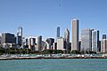
Chicago skyline, a major city in Cook County
.jpg)
See also
 In Spanish: Condado de Cook (Illinois) para niños
